Alexandria's founded by Alexander

Alexandria's founded by Alexander the Great (by year BC): 334 Alexandria in Troia (Turkey) - 333 Alexandria at Issus/Alexandrette (Iskenderun, Turkey) - 332 Alexandria of Caria/by the Latmos (Alinda, Turkey) - 331 Alexandria Mygdoniae - 331 Alexandria (Egypt) - 330 Alexandria Ariana (Herat, Afghanistan) - 330 Alexandria of the Prophthasia/in Dragiana/Phrada (Farah, Afghanistan) - 330 Alexandria in Arachosia (Kandahar, Afghanistan) - 330 Alexandria in the Caucasus (Begram, Afghanistan) - 329 Alexandria of the Paropanisades (Ghazni, Afghanistan) - 329 Alexandria Eschate or Ultima (Khodjend, Tajikistan) - 329 Alexandria on the Oxus (Termez, Afghanistan) - 328 Alexandria in Margiana (Merv, Turkmenistan) - 326 Alexandria Nicaea (on the Hydaspes, India) - 326 Alexandria Bucephala (on the Hydaspes, India) - 325 Alexandria Sogdia - 325 Alexandria Oreitide - 325 Alexandria in Opiene / Alexandria on the Indus (confluence of Indus & Acesines, India) - 325 Alexandria Rambacia (Bela, Pakistan) - 325 Alexandria Xylinepolis (Patala, India) - 325 Alexandria in Carminia (Gulashkird, Iran) - 324 Alexandria-on-the-Tigris/Antiochia-in-Susiana/Charax (Spasinou Charax on the Tigris, Iraq) - ?Alexandria of Carmahle? (Kahnu)
Showing posts with label Apollonia (AL). Show all posts

Tuesday, September 5, 2023

Bronze equestrian statuette from Albania

The Getty Villa Museum in Malibu, California, is hosting a special exhibition, The Horse and Rider from Albania from July 26, 2023, through January 29, 2024. The centerpiece is a beautiful bronze equestrian statuette that was found in 2018 by a farmer plowing his land. This happened near the ancient city of Arnisa, modern Babunjë. Based on the Geography of Claudius Ptolemy from the 2nd century AD, Arnisa belonged to the Illyrian Taulantians. 

Greek, 520–500 B.C. Bronze. Albanian Institute of Archaeology, Tirana.

The city was settled by people from nearby Apollonia (see: Along the Via Egnatia: from Ohrid to Elbasan) in the early 6th century BC. It was an ideal location close to the river Seman with ample fertile land. Arnisa itself was built according to the Hippodamian plan (see: The Hippodamian plan, not so Greek after all) and covered an area of five to six hectares. It was surrounded by a fortification wall made of carefully carved blocks that perfectly fit together as seen in other Illyrian cities in Albania. 

Although only a small part of Arnisa has been excavated so far, archaeologists believe that the city flourished in the 5th and 4th centuries BC, and was abandoned in the 3rd century BC when Macedonia rose to power after Alexander's conquests. Others are inclined to put an end to its prosperity in the days it was defeated by the Romans. 

The small Horse and Rider is approximately 14.5 cm high and has been tentatively dated to around 500 BC. It was cast in one piece of solid bronze and the rider’s face and the horse’s nostrils and eyes were carefully carved. 

Nothing of the kind has been found so far in Albania and scholars hope that future excavations will provide more information about the site of Arnisa and the history of Albania. 

After the exhibition at the Getty, the precious statuette will return home and find a proper place at the National Historical Museum of Tirana.

Saturday, March 11, 2023

How Macedonian is a Macedonian shield?

When talking about Macedonian shields, our thoughts automatically turn to those carrying a 16-rayed star like the one on the lid of King Philip's golden larnax displayed at the Museum of Vergina. 

What should be simple and straightforward, in reality, isn't. 

The first king to use the Macedonian sun emblem may be Archelaus (413-399 BC), i.e., well before Philip II came to power. In Alexander's days, the number of sun rays varied from eight to twelve or sixteen. Alternatively, the center of the shield could be a disc that remained blank or was filled with a Gorgon's head, the face of Heracles, etc. Such a disc was usually surrounded by a varying number of crescents. Other shields may seem unadorned, but it has been documented that many were painted only. That would make sense when looking at the row of armor and shields lining the street in Dion. The monument was commissioned by Alexander after his victory at the Granicus. 

As I have come across many examples of shield decorations, either on paintings, reliefs, coins, or other works of art, it might be interesting to highlight some examples. 

For a start, today's flag of the Republic of Macedonia shows a sun with 16 rays, the so-called "Vergina-Sun." 

A bucranium found in Apollonia Pontica, modern Sozopol, Bulgaria, shows an eight-rayed star, which leads that country to claim that the origin of the "Vergina-Sun" is theirs (see: The Origin of the Macedonian star was Thracian?)

The excavations in Albania have so far yielded several examples of shields they call Illyrian but look very Macedonian at first glance. I was told that the difference with a Macedonian shield was the curving. Whether that is true or not, I don't know (see: Looking for Illyrian remains in Albania).

At the small Museum of Apollonia, Albania, I saw my first Illyrian shield from the 4th century BC that looked very much like the Macedonian one. A series of triple crescents surrounds the central Medusa head with shiny eyes.

The Skanderberg Museum proudly exhibits an Illyrian shield with similar half-crescents but with a six-rayed star at its center.

Two Illyrian shields are embossed on a leather belt buckle at the Archaeological Museum of Tirana. In this case, we see a central disc surrounded by respectively four and five larger double crescents. 

From the same period, a striking limestone mold for a leather shield cover was found in Egypt. It was made for the soldiers of Ptolemy in 330 BC. It has typical Macedonian features with a central Medusa head surrounded by triple concentric circles holding a small eight-rayed Macedonian star (see: Alexander's Legacy. Allard Pierson Museum in Amsterdam). 

The Tomb of Agios Athanasios from the era of Alexander has been attributed to a Macedonian nobleman. Although looted in antiquity, the narrow frieze above the entrance holds precious information about Macedonian daily life and its army in blazing colors. The lively scenes have been photographed in detail and digitally restored for all to examine at the Archaeological Museum of Thessaloniki (see: The Macedonian Tomb of Agios Athanasios in Thessaloniki). Of particular interest are the three shields, two of which show an eight-rayed star surrounded by a broad-colored rim. These shields are painted, as are other examples on the walls of grave monuments. It remains an intriguing question whether shields used in combat were painted as well. Color coding may have contributed to bringing soldiers of the same unit together. Still, I fail to see how Alexander's Macedonians would have carried paint to maintain the distinctive coding during the many skirmishes and battles.

A unique set of shields can be admired inside the Tomb of Lyson and Kallikles in Lefkadia, Greece (see: Alexander's schooling at Mieza). The one painted in the north lunette has a blue eight-rayed star at its center and is edged with a crown of leaves. The shield in the south lunette is defined as the 'familiar Macedonian' shield with an empty disc at its center and surrounded by eight crescents. The tomb is dated to c.250 BC. 

Another specimen is a bronze shield from the collection of the Getty Museum in Malibu, California. It definitely has a Macedonian look because of the central six-rayed star (see: A magnificent Greek shield). The inscription reveals that it was made in Pontus on the Black Sea for King Pharnaces I. Since we do not know when exactly Pharnaces died, we can only assume it was made between 160 and 154 BC, when his brother Mithridates IV succeeded him to the throne. 

From the cities that disappeared under the ashes of Mount Vesuvius after the eruption of 79 AD, I like the fresco from Boscoreale, now at the Archaeological Museum of Naples (see: Fresco of a Macedonian at Boscoreale). The painting, based on a mid-3rd century BC original, was retrieved from the Villa of P. Fannius Synistor and shows a scene in which the principal figure sits next to an eight-rayed Macedonian shield resting at his feet. According to some sources, it would depict Antigonus II Gonatas (the son of Demetrios I of Macedonia) with his mother, Phila, or simply be the personification of Macedonia and Asia/Persia.

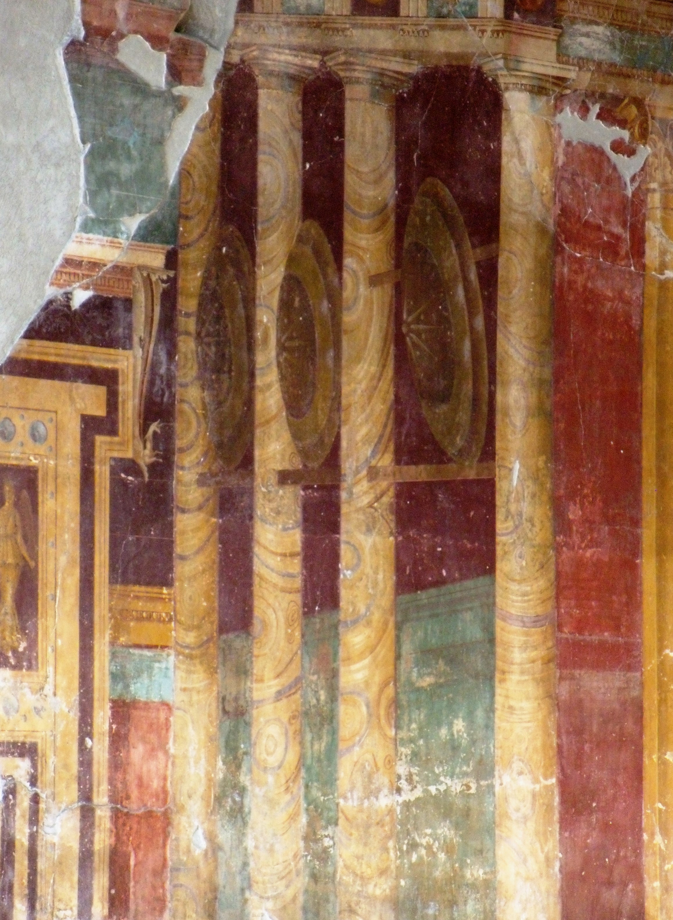
Another magnificent fresco is still in situ at the Villa of Poppea, Nero's wife, in nearby Oplontis. A life-size view of the Temple of Apollo with eight-rayed Macedonian shields painted between the columns covers a wall in the large sitting room. Wow! 

Later rulers and countries held Alexander and Macedonia in great esteem, and the Romans' admiration is an obvious example!

Tuesday, October 9, 2018

High stakes at Corinth

When Philip was proclaimed leader of all the Greeks at Corinth, he was clever enough to insert a clause in the treaty-making his title hereditary. Each state had individually sworn not to harm any other member of the Common Peace and not to interfere in their internal affairs. They also had sworn not to become allies with any foreign power that could damage any member of the Treaty. No member could undertake any operation that might endanger the peace or overthrow its constitution. The then assembled council or synedrion at Corinth was the final authority to settle any dispute between individuals or between member states. They had to help each other if one of the members was attacked but were not allowed to accept support from foreign powers.

This means that after the assassination of Philip in 336 BC, it was one of Alexander’s priorities to be accepted and confirmed as Hegemon of this League of Corinth.

Walking around the impressive remains of Corinth, crowned by the Temple of Apollo, which Alexander saw in all its glory, makes you wonder where these meetings took place. The most obvious location would be the theatre rebuilt early 4th century BC on the foundations of an older one from the 5th century BC. This theater could seat around 15,000 spectators, but there is very little left of this building. There is also a Bouleuterion behind the Agora to consider, but this turns out to be a Roman construction that didn’t exist in Philip’s days.

The Lechaion Street, which connected the center of Corinth to the western harbor of the same name, is one of the highlights of the city. In recent years, expert divers have been exploring the very harbor of Lechaion to expose the infrastructure of this important port city, locating two monumental piers built of ashlar blocks next to a smaller dock. They also found a canal entrance leading into Lechaion’s three inner harbors, as well as a breakwater.

Lechaion was only one of Corinth’s harbors, as the city strategically straddles the isthmus between mainland Greece and the Peloponnesus (less than 6 kilometers wide), which means that it needed both an eastern and a western harbor. Lechaion, on the Gulf of Corinth, served the western sea routes to Italy, Sicily, and beyond to Spain. The harbor of Kenchreai gave access to the Saronic Gulf from where the ships sailed to and from the Aegean, Asia Minor, Cyprus, Syria, and Egypt. Goods could be transported overland from one port to the other as lightweight ships were hauled using a platform along the road connecting Lechaion to Kenchreai. This was before Nero planned to dig a canal meant to link both sides, a plan that eventually materialized two thousand years later. The remains of Kenchreai Street are not as impressive as Lechaion Street, which is tucked away behind the shops of the Agora, but both were familiar to Alexander.

The Temple of Apollo certainly is the main landmark. It is built in Doric order, counting 6x15 columns, seven of which are still standing and define the skyline of Corinth. Rather unique is the fact that the columns are monolithic and stand more than seven meters tall. It is here that the slight convex floor to support the temple’s columns has been implemented for the first time, antedating the much-praised concept for the Parthenon in Athens! There is no trace of the bronze statue of Apollo that once stood inside the temple, as mentioned by Pausanias.

Another unmistakable feature in Corinth is the Fountain of Peirene, built in the late 6th century BC and enhanced many times, especially by the Romans in the 2nd century AD. Much older, and probably built together with the Temple of Apollo, is the adjacent Fountain of Glauke, an inelegant cube of about 7.5 meters. Inside is a succession of reservoirs with a total capacity of approximately 527 m3. Water management in antiquity was far more sophisticated than generally admitted.

Since its early beginning, Corinth was a booming trading hub in the eastern Mediterranean and has a lot to tell. For more than one thousand years, roughly from the 6th century BC till the 6th century AD, the city was at the center of all trade carried out by its mixed population of Greeks, Romans, and Jews, and later by early Christians as well. The importance of this city cannot be stressed enough, and few people know about the many colonies Corinth founded all over the Mediterranean. As early as 733 BC, the first such colonies were established at Corcyra (Corfu) and Syracuse (Sicily). Less than a century later, many more settlements followed, like Epidamnus (Dϋrres) and Apollonia (Fier), both in Illyria, modern Albania, as well as Potidaea in Chalcidice, Greece. Corinth was also one of the co-founders of Naucratis in ancient Egypt. These facts alone prove the overall importance of the city, which rivaled Athens and Thebes.

It is not difficult to imagine the hustle and bustle of people in Alexander’s days, merchants talking feverishly with buyers and sellers, while seafarers were seeking the distractions common to every port - temples, taverns, and brothels are the same all over the world. Sacrifices to the local and foreign gods were being made to thank them for their safe arrival and to pray for a safe journey onward. Corinth certainly was no exception.


If the story is true, it was here that Alexander met Diogenes (see: Alexander meeting Diogenes in Corinth). This Cynic philosopher originated from the Black Sea and died in Corinth the same year as Alexander, in 323 BC. Diogenes’ own writings have not survived, but were known by his disciple Onesicritus, who accompanied Alexander on his Asian campaigns. It may be thanks to him and Ptolemy that his philosophy slipped into the later Alexander Romance.

Friday, May 15, 2015

Revealing Byllis in ancient Illyria

Before my trip to Albania in search of Illyrian remains (see: A closer look at Illyria), I had never heard of Byllis, for even on the internet, the information is pretty scant and vague. Yet the site of Byllis is one of those where you feel at home and where every ruin is exactly as it should be – a very strange awareness!

The location of Byllis has nothing to envy any antique city and certainly not any Greek or Roman city situated at the border between Illyria and Epirus. Had I studied the life and conquests of Pyrrhus of Epirus more closely (which I’ll do pretty soon), I would inevitably have come to this remarkable city, but at this stage, it is a blank page. The origins of Byllis are still obscure, but according to one theory, it may well have been founded by this very King Pyrrhus, who is still held in high esteem today. Another theory, confirmed by numismatics, pretends, however, that the city was built by Myrmidons returning from the Trojan War.

Byllis is perched high on top of a hill, some 520 meters above sea level, overlooking the Vjosa River and definitely occupying a strong strategic position. The city is surrounded by sturdy Hellenistic walls over a distance of more than two kilometers, 3.5 meters thick, and reaching a height of eight to nine meters; it is interrupted by six fortified entrance gates. No less than four inscriptions testify to the reconstruction by the Byzantine engineer Victorinus, who worked upon instructions of Emperor Justinian (end of 5th-early 6th century AD).  Enough of this wall has survived to underscore the sense of security the inhabitants must have felt. To me, it looks like an eagle’s nest overlooking and commanding the entire valley below.

It is, however, very difficult to label Byllis as Illyrian since the vehicular language was Greek (although most people were bilingual) and all the institutions, officials, fortifications, and city planning were clearly Greek also. The ancient road to Apollonia ran right through Byllis, connecting the city with Macedonia at one end and with Antigonea in Epirus on the other side. Buildings like the stadium and theater, for instance, are pure Hellenistic.

I first walk through so-called storage rooms, but it is unclear why they were built here and who could profit from this storage area. Huge earthen jars and pots, now in shards, remind me of Minoan pottery and were definitely well-secured by the maze of thick-walled rooms.

Pretty soon, I arrive at the recognizable Forum – no doubt built on top of the Hellenistic Agora - surrounded by an L-shaped Stoa, two stories high. The earliest agora has been dated to the second quarter of the 3rd century BC, and the 11.4 meters-wide Stoa ran over a total length of 144 meters: the eastern wing (partially cut out of the rock) was 37 meters long and the southern wing 73 meters. The supporting columns were of Doric order, with hexagonal columns on the ground floor, while Ionic columns on the upper floor supported the roof. The set-up of this Stoa is inspired by the one at Apollonia (see: Along the Via Egnatia: Apollonia). Later, the Byzantines built their basilicas inside and in between these remains, meaning that one has to be alert when looking at stones and walls, but the typical Byzantine crosses on column capitals and altar slabs are very helpful.

Comfortably nestled against the hillside, most of the theater has survived, although it has been used as a quarry by the Byzantines.  The original Greek theater was built in the middle of the 3rd century BC and counted 40 tiers, providing seating for as many as 7,500 spectators, which, based on the size of Byllis, means that visitors from neighboring towns attended the performances. It is said to resemble the theater of Dodona in neighboring Epirus, but I am not in a position to compare. Clearly, this theater has been “updated” by the Romans, who added the skena of which only the foundations remain. A corner of the seating area has been reconstructed to give a better feel of the building, and it is interesting to look around for the many details of decorations for the walls, seats, and the trimmings of the skena. I find it striking that the VIP seats are still present around the orchestra in Greek fashion, meaning that this theater was never adapted to be used for animal fights, as the Romans generally loved to organize. The view from up here is, as always, breathtaking!

Turning away from the steep edge on which the theater stands, are the remains of the arsenal, also from the 3rd century BC, and reconstructed during the 1st century AD using the so-called opus reticulatum technique (square diamond-shaped tufa blocks positioned with their corners downwards). It lies about three meters below the adjacent prytaneion (sacred meeting place) and measures 18.2x6.2 meters. This prytaneion, dedicated to Artemis, in turn, is 20 meters long by 6 meters wide and may well be one of the earliest buildings in the Agora.

Byllis also had a stadium from the end of the third century BC, one of the strangest constructions I have ever seen. Only one side of this stadium has been preserved. From the original length of 190 meters, the bottom seating stairs have survived over 134 meters. Near the theater, we can find as many as 19 steps still in place, but overall, there are no more than three or four. But what makes this track so unique is that it runs alongside a huge public water cistern of 51 meters and 4.2 meters wide. This means that this vaulted cistern with a capacity of about 1,200 m3 was constructed underneath the stadium itself. The water was collected from the roofs of the Stoa and from the stairs on the south side of the stadium. In Byzantine times, Emperor Justinian built his baths right next to this cistern, and the facilities were used till around 550 AD.

Remarkably, some remains of private houses have been excavated as well, both Hellenistic and Roman, which I think is rather unusual. Hellenistic houses are rare, and I’m glad to find a clear layout for one of them. It dates from the third century BC and measures 30m x 25m. It is built around a central courtyard of approximately 10m x 10m surrounded by colonnades behind which we find the various rooms; typically, it had its own well (see also: Olynthus and its houses).

All in all, I find it strange that neither here at Byllis nor at any of the other ancient cities in the area (Apollonia, Brundisium, Buthrotum, Dyrrhachium) so little remains from the Macedonian occupation of Alexander and his father, Philip II, before him. Obviously, neither king was there to build a city as their only purpose was to submit the Illyrians as a whole, but since it was the Greeks who colonized this region in the first place, it is awkward to find only sporadic remains of that period – unless the Romans have thoroughly destroyed the buildings that existed previously in those settlements.

[Click here to see all pictures of Byllis]

Tuesday, March 17, 2015

Along the Via Egnatia: from Ohrid to Elbasan in Illyria

The Via Egnatia entered Illyria at Ohrid in the east, then ran through Elbasan, from where one arm connected directly to Dyrrhachion (see: Along the Via Egnatia: Dyrrhachion in Illyria). Another one diverged to Apollonia and Antipatrea (Berat) to end also in Dyrrhachion on the Adriatic coast, where ships ferried people and goods to Brundisium (Brindisi) on the Italian side. As mentioned earlier, the Via Egnatia was built by the Romans in the 2nd century AD and served as a major connection between Byzantium and Rome (see: Via Egnatia, a road to remember).  

The first traces of Ohrid go back to the conquest by Philip II of Macedonia, Alexander’s father, when the city was still called Lychnidos. After a first truce with the Illyrian King Bardylis that was sealed in 360 BC by marrying his granddaughter Audata, Philip attacked in force in 357 BC, killing some 7,000 Illyrians. The outcome was that Philip extended the power of Macedonia all the way to Lake Ohrid, a territory that Alexander inherited. After the tumultuous and unstable centuries after Alexander’s death, the Romans arrived in 148 BC. By the end of the 3rd century AD, most classical and Hellenistic temples were torn down by the early Christians, who built their colossal churches right on top. The very name Ohrid, however, appears for the first time in 879 AD.

Today, Ohrid is part of the Republic of Northern Macedonia and a pilgrimage site because of its many early Christian churches. The city counts as many as 365 of them, and the monastery of Saint Naum (established in 905) may well be the oldest.

Well, this takes me too far away from Alexander’s days, of which close to nothing remains. There is, however, the ancient theatre, built in 200 BC, which is the only one from Hellenistic times since all others in the Republic of Northern Macedonia are Roman. The location of this theatre is, as always, sublime, gently nestled between two hills with a breathtaking view over Lake Ohrid. Unfortunately, only the lower section of this theater has been preserved, and we have no estimate of its seating capacity. It was initially used for gladiator fights, but soon served as an execution place for the early Christians. The locals resented these practices, and after the demise of the Roman Empire, they buried the theater under a thick layer of soil. This is actually the part we are seeing today, which was discovered by accident in the 1980s during construction works.

However, I have not seen any traces of the Via Egnatia here at Ohrid. It is almost impossible to enter the city without passing through one of the two gates in the defensive walls from the 10th century, which the Ottomans continued to use, so this may be a place to look for this famous road.

I had more luck at Elbasan, where the route of the Via Egnatia has been clearly picked up and is even signposted as “The Rehabilitation of the Egnatia Road was funded by the European Union”. It runs right through the city center, and I wonder whether someone did search for its original pavement. It now blends in with the neighboring streets, although it has been established to match the Roman Decumanus of Elbasan. Well, it is exciting anyway to find some traces!

Luckily, Elbasan has more to offer. Outside the city walls, one cannot miss the remains of a Byzantine Basilica from the 5th-6th century, where mosaic floors and painted walls were found. Today, it is a park where the locals linger in the shade of the trees and drink from the adjacent well, decorated with slabs recuperated from the basilica. The city walls here are quite impressive and in a good state of conservation. The first to protect the city was obviously the Romans, who, in the 3rd or 4th century, built a substantial fortress with towers. Later, Emperor Justinian improved the fortifications, which were, however, of no use against the repeated attacks of the Huns and other invaders from the north. Reconstruction started under Sultan Mehmet II in 1466, and Elbasan remained a main Ottoman center for the next 450 years or so. This means that these sturdy walls were maintained till the early 20th century, and it shows.

So, in the end, there is still a lot of work to do in order to map this famous Via Egnatia. I hope that in time, more of its itinerary and pavement will surface.

[Click here to see all my pictures of Ohrid]

Thursday, March 5, 2015

Along the Via Egnatia: Dyrrhachion in Illyria

Except for the significant remains in Apollonia, which I discussed earlier (see: Along the Via Egnatia: Apollonia in Illyria), the other cities along the Via Egnatia have little remains to offer, merely indications of where to find its course. As poor as those remains are, I am trying to gather as much information as possible in this corner of Illyria (today’s Albania), stopping this time at Dyrrhachion.

As mentioned before, the Via Egnatia (see: Via Egnatia, a road to remember) was built by the Romans in the 2nd century AD and was the main road between Byzantium and Rome. As far as Illyria, the road came from Ohrid (Republic of Northern Macedonia) in the east and then ran through Elbasan, from where one arm connected directly to Dyrrhachion (Dürres). Another one diverged to Apollonia and Antipatrea (Berat) to end also in Dyrrhachion on the Adriatic coast where ships ferried people and goods to Brundisium (Brindisi) on the Italian side.

This time, I’m stopping at the most western end of the Via Egnatia on the Illyrian side of the Adriatic Sea, i.e., at the city of Dyrrhachion situated at the narrow in the Adriatic Sea right across from Brindisi, some 200 km to the west. The only significant testimony from antiquity that is left for us to see is the Roman amphitheater from the first half of the 2nd century AD, and even this is incomplete since there are still modern houses sitting on top of it. Yet it is rather interesting to wander through the vaulted corridors, discovering even a small Byzantine chapel. The oval amphitheater reached its longest diameter of 120 meters and stood originally 20 meters high. It offered seating for 15,000-18,000 spectators who watched gladiator fights, animal combats, or other artistic shows. It is sad, though, to see that all the seating material has been removed – most probably reused somewhere else. Yet in spite of its bareness and partial excavation, it is a most impressive construction.

As early as 627 BC, the first colonists from Corinth and Corfu founded the city of Epidamnos, named after the Illyrian King Epidamnos, its co-founder. The king’s daughter had a son who received the name Dyrrhachion, and it was this name that stuck. Dyrrhachion was the ideal location for a city, built around a natural harbor with high cliffs and protected on the land side by swamps.

Obviously, the envious Romans had their mind set on this prosperous city and after a fierce fight with the Illyrians in 229 BC, they took possession of the city, which they renamed Dyrrhachium, modern Dürres.

Dyrrhachium was the site of a battle during Caesar’s Civil War on 10 July 48 BC. He faced Pompey, who came out victorious, although not for long. The decisive battle of the Civil War was fought at Pharsalus in Central Greece on 9 August of that same year. This battle eventually led to Pompey's assassination on 3 September 48 BC. Another waste of lives in history …

Emperor Augustus turned the city into a colony for his veterans after the Battle of Actium, proclaiming it to be a free town. By the 4th century, Dyrrhachium became the capital of the Roman Province of Epirus Nova, but it was soon hit by a severe earthquake that destroyed the city’s defense walls. They were almost immediately rebuilt to a height of 12 meters and were wide enough for four horsemen to ride abreast on them. The remaining portions of the wall from the fifth century are still in place but have lost most of their strength and were first reshaped by the Byzantine Emperor Anastasios I after the catastrophic earthquake of 345 AD. He defended the city with three rows of walls guarded by consecutive fortification towers every 60-65 meters. During later occupations, the walls were modified several times. Dyrrhachium did not escape the repeated attacks by the Huns, but in Byzantine times, the city gained importance as a major link with Western Europe once again. 

There are no traces of the Via Egnatia in Dürres, but I am pointed towards a tall apartment building near the beach that supposedly stands on top of it. The nearby lonely Venetian tower from the 15th century is said to be built over an earlier Byzantine construction while reusing its stones. It stands nine meters tall with a diameter of 16 meters and is surrounded by intriguing modern pebble mosaics with birds and fish moving around in a black-and-white pattern.

[Click here to see all my images of Dürres]

Wednesday, February 18, 2015

Along the Via Egnatia: Apollonia in Illyria

The Via Egnatia, as mentioned earlier (see: Via Egnatia, a road to remember), was built by the Romans in the 2nd century AD and served as a major connection between Byzantium and Rome. As far as the Illyrian part is concerned, the road came from Ohrid (Republic of Macedonia), then ran through Elbasan, where it split in two, one arm connecting directly to Dyrrhachion (Dürres) and another one crossing Apollonia and Antipatrea (Berat) to end also in Dyrrhachion on the Adriatic coast where ships ferried people and goods to Brundisium (Brindisi) on the Italian side. 

To name a city after the sun god Apollo seems to have been very popular in Greek history as we find several cities by the name of Apollonia in Turkey (Lycia, Mysia, Pisidia, etc.); in Sicily, Italy; in Greece itself (Thessaloniki, Chalcidice, Kavalla, etc.) and in Crete; in Libya, where it was the harbor of wealthy Cyrene; and finally here in Illyria, modern Albania.

This time, I’ll be concentrating on Apollonia in Albania, located about 7 kilometers from Fier (see: Alexander’s psychological warfare in Pelium, Illyria). The city is well documented during Roman times, and the remains are obviously very Roman too. For Alexander, this was deep into the Illyrian country, just beyond the northern border of Epirus.

The original name was Gylakeia, after its founder Gylax, who belonged to the Illyrian tribe of the Taulantii. It was the Greek colonists migrating from Corinth and Corfu in 588 BC who changed the name to Apollonia. They were the ones who controlled the city and ruled over the Illyrians. Money was made from the slave trade and agriculture, but maybe mostly through the supply of asphalt, which was a valuable material for the caulking of ships in antiquity. Located on a branch of the Via Egnatia, it is obvious that it was an important harbor along the Illyrian coastline to link up with Brindisi on the other side of the Adriatic Sea and a transit port for all kinds of goods traveling between Byzantium and Rome.

This is the area where King Pyrrhus (a great-nephew of Olympias and cousin of Alexander the Great) ruled roughly from 306 to 272 BC while mingling in Macedonian affairs in the wake of the Diadochi Wars. He tried to keep the Romans out of Illyria, but by 229 BC, they firmly established themselves. I find it rather strange that Apollonia, like so many other Illyrian cities, was so loyal to the Romans. Maybe that is because the city was rewarded with the booty taken from their defeated King Gentius of Illyria – not very patriotic, I would say. By 148 BC, Apollonia became part of the Roman province of Macedonia, Epirus Nova. About a century later, the city supported Julius Caesar in his war against Pompey but fell into the hands of Brutus in 48 BC. Apollonia could also claim to have contributed to the education of Emperor Augustus, who studied at its famous school of philosophy in 44 BC, where Athenodorus of Tarsus was his teacher. Together with other cities in the area, Apollonia flourished and was even mentioned by Cicero as “magna urbs et gravis”, meaning “a great and important city”. Strabo also mentions the city in his Geographica as “an exceedingly well-governed city”. Decline set in during the third century AD when its harbor started silting up after being hit by a severe earthquake, which changed the course of the Aoos River. The inland turned into an ever-growing malaria-ridden swamp, and the inhabitants moved out to resettle at nearby Avlona (modern Vlore).  Only a small Christian community that moved in during the very early days of Christianity remained; they may have built the first church of Saint Mary. Today’s church dates from the 14th century and houses the local museum.

The visitor’s attention is immediately drawn toward a colonnaded façade that could be part of a temple. Still, it turns out to be the entrance to the Bouleuterion from the second century AD – quite unusual since generally, the tiers of such a city council survive but not the portal. The columns are definitely Corinthian, and in the architrave above them, we can still read the Greek dedication: “To the memory and in honor of Valentinus Villius Furius Proculus from his brother Quintus Villius Crispinus Furius Proculus, prefect of a cohort in Syria, tribune of the Legion Gemina in Pannonia, and president of the sacred games. A fight of 25 gladiators was held for the inauguration.” This Bouleuterion is surrounded on three sides by rooms, some kind of annexes to the Ionic Temple next to it. What is left are mainly low walls, and archaeologists suppose that these rooms were used for administration or for the priests’ duties. The outlines of the temple itself are easily located with a few columns sticking out from the grass.

Across from the Bouleuterion are two big stumps of stone indicating the site of a triumphal arch at the end of the street leading into Apollonia and dating from the 3rd century AD. To the right, but difficult to make out, are the remains of a Library from the 2nd-3rd century AD, proof of the city’s importance – if needed. On the other side of the street lies an Odeon that has been carefully restored and could hold as many as 650 spectators. Adjacent is a small Sacellum, an open sanctuary dedicated to an imperial cult. The niche was most probably flanked by two Ionic columns, and we still can see the rosettes and lion paws of their base.

It is followed by a portico, 78 meters long, punctuated by 17 niches that once held marble statues. This portico seems to date from the 4th century BC and was divided lengthwise into two by a row of Doric columns, whereas the outside columns were of Ionic style. I am told that this kind of structure is unique for Apollonia.

The portico ends at the Sacred Road, where we find a temple right around the corner, dating from the second half of the 2nd century BC but probably renovated four centuries later and possibly dedicated to Jupiter, Juno, and Minerva. The Sacred Road continues further uphill to the Acropolis, where little or no excavations have been done. With a width of nine meters, it is the widest street so far in Apollonia, paved with river pebbles laid directly on the clay surface.

On the other side of this Sacred Road are three vaulted shops, almost square in shape (3.45x3.40m), whose entrance could be closed by heavy double doors. The walls were very thick to keep out the moisture and guarantee a nearly constant temperature in order to preserve the goods stocked inside. They seem to have been built during the second half of the second century AD. Against these shops, another construction deserves our attention, for this is a water cistern that was used from the 4th century BC all the way to the 2nd century BC and has still kept its impermeable inside coating.

Opposite this Sacred Road are the remains of a large villa, in fact, no more than a succession of mosaic floors. The house was divided into four parts: an entrance portico of 14x5.8 m right opposite the Sacred Road; the main room measuring 12x11.8m with a center of white mosaics surrounded on all four sides by a corridor 2.9 m wide paved with little brick squares of 5x5 cm; the back room overlooking the sea. It is thought that this house was used as a gathering place for the believers before starting their procession over the Sacred Road. The most precious mosaics have been covered, of course, but the remaining ones are quite interesting. The attentive visitor will also notice the clearly Roman sewage system running parallel to this building.

Like every single Greek city, the location of Apollonia was chosen with the greatest care, overlooking the Aoos River and its fertile valley with the Adriatic Sea at the far horizon.

My greatest surprise, however, was the local museum, housed in the 14th-century monastery attached to the church of St Mary, by itself worth a visit. Under the watchful eyes of the soaring Pantocrator, it is easy to discover all sorts of antique fragments: Corinthian capitals placed upside-down to serve as a base for some Christian relic or flowers; the marble wall of a well with deep gutters left by the ropes that pulled the water-buckets over the centuries and now on dry land; small lidless sarcophagi turned into mini-gardens; and other spolia spotted in the outside walls. In the upstairs portico leading to the very entrance of the museum, several grave steles and smaller altars have found refuge.

Since I have been walking through Roman Apollonia, I expect this museum to reflect that image. Well, not entirely so, for originally, the city was founded by Greeks who imported the art from their hometowns or created their own imitation. I walk among Attic vases and hydras from the 5th century BC, Apollonian bottles and pots, but also some Italic imports. The Hellenistic period is also very present with several marble steles, reliefs, busts, and statues, but the eye-catcher is this wonderful shield that I immediately recognize as Macedonian. But wait a moment … according to the label it seems to be Illyrian! How on earth is that possible? I take a closer look at this splendid piece with three concentric circles in its center, around the frightening head of a Gorgon in Classical Greek style, sticking out its tongue and staring at me with shiny inlaid eyes. The border of the shield also counts three concentric rows of circles framing six half-circles around the edge. I fail to see what makes it Illyrian and inquire with the museum director, who tells me that the difference lies in the curving. Well, I suppose he knows, but I am not entirely convinced till I see other examples of Illyrian shields later on in Tirana and at the Skanderberg Museum. I’m totally baffled by this revelation! Ironically, the Illyrian shield in Apollonia is presented next to a splendid Macedonian helmet that has been dated to 314-312 BC, a rather narrow timeline.

So, all in all, Apollonia was definitely worth a visit, including the local museum. Some artifacts, however, have been moved to the national museum at Tirana, where I discovered a hoard of silver drachmae from the 1st century BC, as well as a head of Demosthenes (1st century AD) – of all people, what is he doing here?

I’m not too far away from Alexander, after all!