Alexandria's founded by Alexander

Alexandria's founded by Alexander the Great (by year BC): 334 Alexandria in Troia (Turkey) - 333 Alexandria at Issus/Alexandrette (Iskenderun, Turkey) - 332 Alexandria of Caria/by the Latmos (Alinda, Turkey) - 331 Alexandria Mygdoniae - 331 Alexandria (Egypt) - 330 Alexandria Ariana (Herat, Afghanistan) - 330 Alexandria of the Prophthasia/in Dragiana/Phrada (Farah, Afghanistan) - 330 Alexandria in Arachosia (Kandahar, Afghanistan) - 330 Alexandria in the Caucasus (Begram, Afghanistan) - 329 Alexandria of the Paropanisades (Ghazni, Afghanistan) - 329 Alexandria Eschate or Ultima (Khodjend, Tajikistan) - 329 Alexandria on the Oxus (Termez, Afghanistan) - 328 Alexandria in Margiana (Merv, Turkmenistan) - 326 Alexandria Nicaea (on the Hydaspes, India) - 326 Alexandria Bucephala (on the Hydaspes, India) - 325 Alexandria Sogdia - 325 Alexandria Oreitide - 325 Alexandria in Opiene / Alexandria on the Indus (confluence of Indus & Acesines, India) - 325 Alexandria Rambacia (Bela, Pakistan) - 325 Alexandria Xylinepolis (Patala, India) - 325 Alexandria in Carminia (Gulashkird, Iran) - 324 Alexandria-on-the-Tigris/Antiochia-in-Susiana/Charax (Spasinou Charax on the Tigris, Iraq) - ?Alexandria of Carmahle? (Kahnu)
Showing posts with label Limyra. Show all posts

Tuesday, September 24, 2024

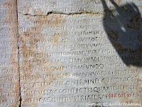
Reading and decoding inscriptions

Today’s visitors will inevitably come across many inscriptions when visiting ancient sites or museums. Reading Greek or Latin is not for everybody, and understanding the meaning of the text and context is reserved only for the happy few. The stone or marble support has more often than not suffered from wear and tear, leaving the untrained eye to merely guess its value. 

We are lucky to find an explanation next to the inscription, rarely a full translation, as those are reserved for scholars. Well, the text may be boring, but it also may contain some exciting twists and turns. Yet, who wants to know? 

In antiquity, people would read the latest laws and decrees, regulations and agreements, peace treaties, manumission of slaves, grave markers, boundary stones, milestones, etc., as they walked through public spaces. Some of these texts are still in situ, particularly those engraved on the walls of still-standing monuments. The majority, however, has found a place in the museum for safekeeping and is often out of sight. 

The most familiar examples of inscriptions are those chiseled on grave steles, sarcophagi, and tombs. They also appear on the pedestals of statues lining the streets like Phaselis Harbor Street or Olympia’s road to the Stadium. Others serve to identify the deities, kings, and emperors that fill the sanctuaries and agoras, or the niches of theatres, stadiums, libraries, baths, Nymphaeums, and other public buildings. 

But some inscriptions will surprise many of us. 

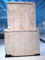
For instance, this stele at the Louvre Museum holds the accounts of the Parthenon Treasury. The text covers both sides of the stele made of Pentelikon marble and illustrates how democracy works. Athens magistrates submitted the public accounts to the citizens for all to see. The front side, beneath a relief of the Sacred Olive Tree flanked by Athena and the people (demos), displays the expenses for military operations, religious ceremonies, and the Panathenaic festival held in honor of their patron goddess for 410-409 BC. The reverse side has the expenditures for 407-406 BC.

In Butrint, Albania, a striking series of inscriptions is carved on the outside walls of the Roman Theater of Buthrotum, as the city was called in antiquity. 
They are hard to read but worth our attention because these are manumissions, slaves who had gained their freedom for whatever reason. Their sheer number is mind-blowing!


As surprising and revealing are the Edicts on prices! Who would have thought that there were strict rules to define the prices of goods in antiquity! 
The first such example I encountered was at Ptolemais in Libya, proclaimed by Emperor Diocletian in 301 AD.

Also by Diocletian is the Edict on maximum prices for products and labor discovered in Halicarnassus, dated to 301 AD. The Emperor hoped to stave off a financial crisis and prevent inflation. 

Although this tablet was unearthed in Bodrum (the modern name for Halicarnassus), bits of similar Edicts were also found in Pergamon, Aizanoi, Aphrodisias, and Stratonikea. It is quite surprising to read that the Edict from Halicarnassus consists of 37 parts. Part 9, for instance, is about shoes and boots … 27 different kinds and sizes are listed!

Taxes are another matter that deserves attention. One such inscription that is hard to miss can be seen on Curetes Street in Ephesos, close to the Library. 
This tax law was written in the second half of the 4th century AD, during the rule of Emperors Valentian I, Valensand Gratian.

Less obvious is Alexander’s tax remission from the wall of the Temple of Athena in Priene, now exhibited in the British Museum in London
Alexander contributed to the cost of building the unfinished temple, and in return, he was allowed to dedicate it: “King Alexander dedicated the temple of Athena Polias”. 
This text was followed by a longer inscription setting out the terms of an agreement between Alexander and Priene under which the city was to be exempt from taxation. 

Not all inscriptions were written in Greek or Latin, and I find it fascinating to hunt for these exceptions. 

Having a closer look at Lycia’s sarcophagi strewn throughout the landscape, I discovered texts that seemed to be written in Greek but are in Lycian, as they contain several odd letters that do not exist in the Greek alphabet. Antiphellos and Limyra have good illustrations of Lycian texts.

Another case is to be found in Sillyum some 25 kilometers northeast of Antalya, an often overlooked site although the hillside is easily spotted in the otherwise flat plain of Pamphylia. 
It takes some detective work to locate the inscription in the Pamphylian language carved in the doorpost of a Hellenistic building – a very rewarding effort though!

The people of ancient Side also had a language of their own. A small inscription has survived and can be seen at the local museum located inside the remains of the Roman Baths.


After Alexander conquered Lycia and Pamphylia, Greek became the lingua franca, and the local tongues disappeared.

Tuesday, March 22, 2016

Xanthus, Travels of Discovery in Turkey by Enid Slatter

Xanthus, Travels of Discovery in Turkey by Enid Slatter (ISBN 0-948695-30-7) is an absolute must for every lover of Greek antiquity and more particularly for those, who like me, fell in love with Lycia in southeastern Turkey.

The title Xanthus, although the main city and once capital of ancient Lycia, may be misleading as the book covers in fact, all of Lycia. The author mainly has reproduced the journals kept by Charles Fellows, who in 1838 and 1840 crisscrossed this unchartered territory looking for architecture worth of filling the newly founded British Museum in London. Occasionally Enid Slatter has added updated information about the whereabouts of certain artifacts.

The journal not only mentions the (generally phonetically spelled) Turkish names of the towns but also the corresponding names from antiquity. The book is further richly illustrated by a huge amount of drawings, some made by Fellows himself, but most of them drawn by young George Scharf, who accompanied him, especially for this purpose.

It gives a great insight into the policy applied by the then-ruling Ottoman government as well as that of the British occupying nearby Rhodes and Malta. The general landscapes with rivers, gorges, scant bridges and fording places are very detailed, but also the overall color pallet of blossoming trees, field flowers, and dresses of the local people. On top of all that, it is quite interesting to learn how Charles Fellows and his entourage traveled from England to Turkey and back, using ferries, carriages, an occasional new train track, steamers, ferries, to continue on horseback or on foot through the pristine Lycian countryside. They suffered from seasickness on many occasions and were thoroughly shaken during the bumpy rides in the stage coaches. In Turkey, they were dependent on the weather and often hit by fierce thunderstorms. The Lycian coast was still infested by swarms of mosquitoes, especially in summer when even the locals moved out en-masse to the inland mountains.

Xanthus was and is, of course, the focal point, but Fellows also put sites like Letoon, Tlos, Pinara, Myra, Limyra, Arykanda, Olympos and Finike on the map, which today are only one flight away for the many tourists.

While during his first trip Charles Fellows aimed to discover as much of Lycia as he could, his second expedition of 1840 was the one that enabled him to crate and ship the magnificent pieces of what is now called the Nereid Monument (or Ionic Monument), the friezes of the Harpy Monument, the entire Payava Tomb (or Horse Tomb), and several other pillar or box tombs now at the British Museum. He also made plaster casts of pertinent reliefs that could not otherwise be moved, which have sadly disappeared since.

The reading is never dull and Fellows’ love for this unique Lycian culture is one of a kind. His journal is truly filled with many exciting details, very much worth discovering.

Wednesday, July 8, 2015

Opramoas of Rhodiapolis

Opramoas was a very wealthy Lycian citizen who lived in the first half of the second century AD in the small town of Rhodiapolis in eastern Lycia near present-day Kumluca (Eskihisar).  He is well-known for his philanthropy and lived during a period when the Roman Empire provided peace in Anatolia and public works in cities were highly developed.  It is not known exactly how Opramoas became so wealthy, but it is known that the rents he received from his lands and the interests he received from commercial ventures and banking operations made up a portion of his wealth.

Not much is left of Rhodiapolis besides a theatre, but the remains of Opramoas’ mausoleum were found there and among the rubble long inscriptions were discovered which once decorated the walls of his tomb.  These long inscriptions describe the good deeds Opramoas performed during his lifetime, letters from the emperor, and records of the assembly.  They are the longest-known inscriptions in Anatolia in the Greek language where information is provided regarding administrative, social, and economic activities and relations.  Other inscriptions found in other Lycian cities give other details about this esteemed man.

Based on inscriptions it is known that Opramoas:
-  Was promoted to prominent posts from 110-155 AD and acted as an administrative, military, and religious leader in the Assembly of the Lycian Federation and in important cities of the region.  He was honored many times in the Assembly of the Federation, many of which were approved by the Roman emperors.
-  Donated much money for rebuilding more than 30 Lycian cities following the catastrophic earthquake in 141 AD in which they were demolished.  At Myra he donated 200,000 denarii to repair the theatre, the Artemis Eleuthera temple, and the gymnasium, assuming the marble decoration of the gymnasium and adjacent peristyle. 
-  Donated money for civic buildings, such as baths and certain oracular shrines.  Many cities received money such as Choma, which received 7,000 denarii towards a stoa and a temple for Augustus. He is also known to have funded the construction of the theaters of Xanthos, Tlos, and LimyraAt Tlos, he donated 60,000 denarii for the "exedra in the baths" and towards the amphitheater.
-  Distributed wheat to needy citizens and donated money for the education and nourishment of needy children.
-  Provided dowries for some government employees and young girls, and funeral expenses for some elderly.
-  Assisted in funding festivals and ceremonies organized in honor of the gods and emperors and held festivals in his name every four years to help pay for these expenditures.
-  Owned lands in many Lycian cities, some of which he donated directly for charitable purposes and others from which he donated the income. 


Researchers have determined that during his lifetime Opramoas contributed approximately 2 billion denarii for these activities - an enormous amount, considering that the wage of a shepherd or manual worker was about 10 denarii.

A man to my heart, one who deserves a statue on a high pedestal!

[Click here to view all my pictures of Rhodiapolis]

Tuesday, January 7, 2014

Alexander’s Path by Freya Stark

Alexander’s Path (ISBN 0879513403) has been on my bookshelves for many years now. The first time I read it was in preparation for my wonderful trip with Peter Sommer, In the Footsteps of Alexander the Great, the full 21-day journey (now split up into two parts). Since then, I grabbed it repeatedly when exploring Pamphylia and Lycia on my own to get those little extra details that make a journey so much more worthwhile. In a surge of melancholy and enriched by my own experiences, I decided to read it once again, cover to cover, making it a most enjoyable mental travel experience. 

What threw me off, at first, is the fact that Freya Stark goes in the opposite direction of Alexander, starting with Alexandrette (Iskenderun) and the Battle of Issus, moving through Cilicia to the great cities of Pamphylia to finally reach Lycia. She travels in the early 1950s when the landscape is not spoiled yet by the crowds of coastal hotels and modern roads, still looking very much like Alexander’s days. Her means of transportation are random, simply adapted to the circumstances: car, jeep, horse, mule, donkey, and on foot. Hotels where she could enjoy a room of her own are rare, and she often simply accepted Turkish hospitality in whatever form and with whatever comfort that may or may not offer.

It is not a dreary recitation of facts or references from ancient authors about Alexander’s march through these lands. On the contrary, she knows how to enhance her story with simple daily realities of life as it evolves: her observation of life in the village, the sound of goats and herders in the hills, her own thoughts as the day passes and the road unwinds. She observes the land with an analytical eye, constantly wondering how an army could cross it and what Alexander’s goal was at that moment in time. 

In the end, she extensively crisscrosses the rugged lands of Lycia in search of Alexander’s path, which has not reached us from ancient literature. Even Arrian, otherwise rather detailed in his descriptions, simply mentioned that Alexander moved from Xanthos through Lycia to Phaselis. Freya Stark has spent several trips exploring every single road, pass, river, and trail of Lycia looking for the most plausible route. She concluded that the Macedonian King either took the coastal road (corresponding mostly to the modern motor road) or the higher ridge via Candyba and Kassaba to Myra and hence to Limyra with another possible deviation via Arykanda to Limyra, to end at Phoenice (modern Finike). Taking advantage of the old well-travelled stony paths and donkey trails, she manages to find the best-fitted passage for Alexander to take his army across the mountain backbone. It passes under Rhodiapolis, through Corydalla (now Kumluca), and over the Yazir Pass to descend on the eastern side to Phaselis

It may be hard to find, but Alexander’s Path not only is a fascinating and captivating book but also a faithful and precious travel companion.

Saturday, May 18, 2013

Alexander the Great in Antalya’s Museum

In the days of Alexander the Great, Antalya did not exist. The city was founded nearly four hundred years later by Attalus II as a compromise in a political conflict. This happened shortly after 158 BC when said Attalus, King of Pergamon, attempted to subdue Side. His plan failed, but in exchange, he was able to add a part of Pamphylia to his kingdom. This operation was not free of danger because the Pamphylian cities loved their independence and stood officially under the protection of Rome. Attalus II did not want to ruffle Roman feathers and could not simply occupy any harbor while he desperately needed one, as otherwise, his occupation of Pamphylia would be pretty useless. He solved the problem the diplomatic way by building an entirely new port, which eventually was named after him, Attaleia, i.e., modern Antalya.

Under Emperor Hadrian, the Attaleia area became an independent province with a senator as their governor. After serving the Crusaders as a supply port and being conquered by the Seljuks, it was finally incorporated into the Ottoman Empire. The city was famous for its fine wines, but under Islamic law, the tradition of wine-making was lost and replaced by the cultivation of roses. So for the next centuries, rose oil for perfumes became the main source of income. More recently, the farming of silkworms was introduced.


There is nothing left to see from Hellenistic times in today’s Antalya, only a few traces of Roman occupation. It is said that the Atatürk Caddesi follows the outlines of the old city wall, which is only visible near the Arch of Hadrian, built in 130 AD with Corinthian columns in its façade and a worn-out Roman road running underneath. This Arch is flanked by two massive towers, cleared as recently as the 1950s. Another relic is the poor remains of the Temple of Zeus, transformed into a Basilica and later on even into a mosque – now in total ruins and in desperate need of restoration. Otherwise, antique Attaleia remains largely hidden underneath the core of “old Antalya” with its narrow streets and Ottoman houses, widely converted into pensyonlar. The Hidirlik Kulesi at the southern end of the port is thought to date from Roman times, but its role is unclear, as some speculate it was meant to be a mausoleum while others believe it was part of the citadel. In any case, this 17-meter-high tower served as a lighthouse for a while.

But the true treasure of Antalya is – in my eyes at least – the Archaeological Museum, for this is where Alexander is waiting for me.

It is a feast each time I visit this Museum, and the thought of seeing all these marvelous statues and well-organized exhibitions is very exciting, although I must have been here at least four or five times before. There always remains something new to discover, a detail I missed on previous occasions, a statue that now demands my special attention, or simply a name that I now recognize.


Among the archaeologists, for instance, there is the name of Cevdet Bayburtluoğlu, 
which I recognize now as the man who excavated Arykanda and most of Lycia, for that matter, and whose discoveries and analysis are publicized in his precious guide “Lycia.” The showcases filled with mostly Roman glasswork from Perge and Patara are always worth special scrutiny, as are the terracotta bowls, cups, and amphorae; the bronze objects and coins; and especially the rings and other pieces of jewelry. 

Of exceptional quality are the many statues from Perge that once enhanced the large theater, the baths, the stadium, the Nymphaeums (fountains), and the Agora. The walls of these rooms have all been painted in pinkish terracotta, making sure the statues of emperors and dignitaries stand out against them. Almost every statue has its own floodlight that switches on as soon as the visitor moves close enough. What a treat! I am particularly impressed by the Diana/Artemis and the Hermes attaching his Sandal, as I know both statues from the Louvre in Paris.  Upon closer look, they differ in slight details: the dress, the sandal, the hairdo, and the position of the feet. These may all remain unnoticed by the casual visitor. Still, I find this terribly interesting because now I can see for myself that a Roman copy of a Greek original is not always an exact copy!

In the room dedicated to the Theater of Perge, I meet up with Alexander the Great, standing tall against a green marble background, pieced together as much as possible and much larger than life-size. He dominates the room, of course. Hi there! He is in good company with an oversized Hermes, Dionysus, and Satyr. Here I also find Plancia Magna, the female demiurge of Perge (literally worker at the service of the people,  a kind of governor that is), who received a place of honor inside the Hellenistic Gate of the city around 120 AD (the base of this statue is still in situ). This shows how emancipated some Romans were in those days! Well, besides this official title, Plancia Magna was also a priestess of Artemis and of the Mother of Gods – quite a lady to reckon with!

After an open space filled with mosaics badly needing a scrub down, I arrive among the sarcophagi – a rich collection in all sorts of styles and from different provenances. I’m happy to find the one belonging to the Lyciarch Mausoleum in Olympos with a top lid on which a couple attends a banquet. It pays off to return to the museum after visiting more excavation sites, for what previously was only a name can now be mentally placed in its original context. This happened, for instance, after visiting Limyra as I can now find the long frieze belonging to the Temple together with the special caryatid from the Heron that was built for the Lycian King Pericles in the 4th century BC; I also get a better idea of the Cenotaph of Caius Caesar for which a detailed reconstruction is shown here.


It is a lot of information and a lot of beauty to take in, and I’m happy to relax for a moment in the museum courtyard to enjoy a cup of tea. After that, I take a last stroll under the awning, along the objects that are not considered good enough to be taken inside. I’m amazed by the many huge amphorae that somehow remind me of Crete and have not suffered any damage at all. Unbelievable!

[Click here to see all the pictures from the Archaeological Museum in Antalya]

Saturday, December 1, 2012

Ancient Myra from Finike

Today I decided to drive to nearby Myra. This is where Santa Claus was buried, not the legend but the real man, Saint Nicolas, of course. His grave is still here although his remains were stolen by Italian merchants in 1087 and taken to Bari, Italy. 

After Finike the coastal road follows the contours of the landscape with every curve around the capes and inside the bays, offering rewarding views at each and every turn. It feels strange to be driving on this well-maintained road that I seem to know so well looking at it from the gulet when I sailed these waters last year. It appeared as a horizontal scar in the landscape, now a winding ribbon of asphalt that is not free of danger from falling rocks. But I enjoy every mile of it. Soon enough I enter the modern town of Demre that fills the entire bay and I am happy to see that there are plenty of road signs directing me to ancient Myra.

Most of the ancient city lies underneath today’s Demre and is hidden under five meters of alluvial silts from the Demre River. This large plain is now almost entirely covered with greenhouses stuffed with tomatoes – very efficient but not exactly a sight for sore eyes.

Myra was first mentioned in the 1st century BC when it was one of the six leading cities of the Lycian League (with Xanthos, Tlos, Pinara, Patara, and Olympos) but its origins are believed to go back to the 5th century BC. The name was spelled MYRRH and the Lycian coins bear the abbreviation ΛΥΚΙΩΝ ΜΥ. Myra once had a great Temple of Artemis Eleuthera (a distinctive form of Cybele), said to be Lycia's largest and most splendid building. However St. Nicolas had the temple completely destroyed. How dared he?!

The ancient city was terribly hit by the earthquake in 141 AD and our friend Opramoas of Rhodiapolis donated no less than 200,000 denarii for its reconstruction, together with two other benefactors, Licinius Langus of Oenoanda and Jason of Kyaenai. Under Emperor Theodosius II it became the capital of the Byzantine Eparchy Lycia. Myra lost one-third of its population to the plague in 542-543 AD, and after subsequent Muslim raids, flooding and earthquakes, it was mostly abandoned by the 11th century. 

Plainly visible upon arrival is the Graeco-Roman Theater of Myra chiseled into the rock and said to be the largest in Lycia and the third largest in Turkey. This is where I start. It is indeed quite impressive and I manage to arrive before the busloads of tourists. I walk between interesting debris of carved stones from the Theater showing theatrical masks and beautiful reliefs of birds, mythological scenes, and, of course, the ever-present Muses. Then I climb all the way to the top, 38 rows above the skene for a complete overview of the modern town of Demre and to get a feeling of what the theater-goers in early times must have seen looking towards the sea. Several rows lower I walk the well-preserved diazoma whose face is rich with inscriptions, niches, and reliefs. The holes in the terraces once held wooden posts to which sunshades could be fastened, just like I have seen before in Limyra and Arykanda. A real touch of luxury, and why not? It seems that in the 3rd century AD, the theater was even used as a circus and for water sports!

Left of the Theater, I can’t miss seeing the many Lycian tombs cut out in the face of the rocks, but they are not accessible for visitors; only the ones of the eastern necropolis are. So I set off to that side but then I don’t find any path in spite of my repeated attempts through the orange groves and medlar orchards. I see a signpost indicating that the Lycian Way passed here, but I wish the backpacker good luck in finding out where he is going for I can’t, and honestly, after yesterday’s experience hunting for Rhodiapolis I lack the energy to investigate much further. An old woman kindly tries to put me back on track, handing me a couple of sweet apples, but in vain! OK, that was that.

Monday, May 5, 2008

Arykanda

My plan today is to visit Arykanda, renowned as being the Delphi of Turkey, and it turns out that this title is not exaggerated. I read that Arykanda overlooks a magnificent valley and that the view makes it one of the most spectacular sites in close competition with Ephesus and Pergamon. It goes without saying that it is one of my top priorities.

The smell of spiced herbs mingles with the sweet, penetrating perfume of orange blossoms when I leave my hotel in the early morning. Traffic in Finike is busy with the Saturday market and the road works as I drive between houses and shops till the sign “Uçumlar, Güle, güle” waves me out. This turns out to be a last greeting from civilization as settlements suddenly become sparse. The road winds between steep green mountains richly covered with thick pine trees. I am all eyes for this is Alexander-country (at least for me!), a majestic and commanding landscape with high peaks crowned with snow. It is a little hazy, not exactly ideal for taking pictures, but my memory will record all the details. The road is twisting and climbing ever higher. Here and there, I catch a glimpse of houses and rows of trees, squeezed between plastic greenhouses that grow smaller at each turn. What a land! The road is well-maintained. This is not as obvious as it sounds, for although this is a centuries-old connection between Finike and Elmali, it has been improved only in the recent decades – lucky me!

After the village of Arif, I see the brown signpost to Arykanda. Yet it is pointing to a high cliff in front of which the locals are setting up their orange stalls. What is this? According to the Sunflower guide “From Antalya to Demre”, I have to make a right turn to reach the Agora of the ancient site, about one kilometer from here. I inspect the rocky wall in front of me, but find no entrance road. I take another look at my detailed map and finally realize that the road is to my right, half behind me, looking over my shoulder – a kind of hairpin turn. It is nothing more than a dirt path indeed, and I pray that I won't meet a car or tractor coming from the opposite direction, but all goes well and I find a space to park. I am the only car and the only visitor, and like the day before, there is nobody to buy my ticket from. Well, my presence will be known soon enough, knowing the Turks …

I’m deeply impressed by what I see. Such a big city! It is so wonderfully well-preserved and excavated - a real gem with many streets and staircases still intact, two Agoras, remains of temples and private Roman houses with mosaics, Basilicas, and cisterns. I feel like a kid in a toy store, I want to see it all at once! Where shall I start? I decide to climb uphill to the two Agoras and adjacent buildings, as at this time of day, it is still cool. To my surprise, there is a billboard with a map of Arykanda and another one with a list of the buildings pointing me in the right direction. These buildings are numbered and referenced on the map, and they match the copy of the map I took with me from Cevdet Bayburtluoğlu’s book on Lycia – well, no wonder, for he is the archaeologist responsible for these excavations!

The Lycian city of Ary-ka-wanda, “the place near the high rocks”, is known to be one of the oldest sites, where even coins from the 5th century BC have been found. My friend Alexander the Great has stopped here on his way from Milas to Phaselis, but if there is any hard proof to this story, I don’t know, for I haven’t found one. After his death, the city was ruled by the Seleucids and afterwards by the Ptolemaic dynasty. It is said that the tension between Limyra and Arykanda, for whatever reason, prevented the influence of Ptolemy from spreading further inland through the valley of Arykandos. In the 2nd century BC, Arykanda joined the Lycian League, and from 43 AD, the city belonged to the Roman province of Lycia and Pamphylia. It even survived Byzantine times, until the 9th century, when the settlement moved to a new site south of the modern road. Luckily for us, the marble and limestone remains have been spared the lime kilns, as no large town was built in the neighborhood. Besides, much of the site has been covered by landslides, meaning that Arykanda's buildings were well hidden. This is why the excavated remains look so clean and almost new. Built upon five large terraces on a mountain slope, the city is quite unique. It was known for having the most pleasure-loving and entertainment-loving (and debt-ridden) citizens. So when in 197 BC they supported Antiochus III in his fight against Ptolemy, it was not so much a political move, but mainly to get their creditors off their backs. Nothing’s new under the sun!

Time to start exploring the site! I’m curious what the plastic roofs next to the parking are sheltering, and I see that there are mosaic floors underneath that seem to belong to a Basilica. Yet I leave this side of the city for later and set off to higher grounds.

[read further in Arykanda 2 - Visiting the Site]

Sunday, May 4, 2008

Limyra, from Finike

My first trip is to Limyra located very close by, in fact right behind my hotel (I later spot it with my binoculars from the balcony) although I have to drive in a wide loop to get there. First down the coast to Finike where the market is wrapping up. I have to pay attention, driving through the crowd of well-built young men carrying empty crates and the belated housewives loaded with plastic bags full of bread and vegetables. Maneuvering further between the potholes and sooner than expected, I see the Roman-Byzantine city wall on my right-hand side, which I recognize as pertaining to Limyra. There is space to park my car, but nobody to welcome me. The kiosk at the entrance is deserted, and the iron gate is locked. Knowing that the visit to the Theater on the other side of the road is free of charge, I decided to start over there.

Basically, this is a Hellenistic Theater that was rebuilt after the earthquake in 141 AD, thanks to the contributions of Opramoas of Rhodiapolis at a time when the city was at its wealthiest and could seat 8,000 people (other sources double that size). It was enlarged during the reign of Emperor Augustus and again in later Roman times, and in the 2nd century AD, a skene was added. Although the Theater is squeezed between the road, the hillside, and the surrounding greenhouses, it is still in rather good condition with niches in the side walls that once held statues, while the diazoma and the vaulted galleries offer lovely pictures of the blossoming mimosa trees on the slopes behind it. 

High up this hill, according to my books, I should find the remains of the Acropolis with a church and the Heroon of Pericles. This Heroon, which was also his tomb, displayed a group of caryatids on the porch, which was inspired by the Erechtheion in Athens or the Monument of the Nereids in Xanthos.  One of the Caryatids and several parts of the frieze from the cella representing Pericles in his chariot surrounded by mounted and foot soldiers are exhibited at the Museum in Antalya. The burial chamber was located in the foundations of the Heroon. 

I have second thoughts about climbing up there, for the hill is very steep (my book states 40-45 degrees!) and the hot air emanating from the many greenhouses makes me feel nauseated. Besides, there will not be much to see for even down here, the landscape is very hazy. I decided to stick to the lower grounds.

Walking back to the car, I see that the ticket booth is now manned. The local voiceless messenger has worked well, as usual. I’m welcomed with a big smile, and after paying my entrance fee, the attendant unlocks the gate for me. Great, I have Limyra all to myself!

Limyra, the Lycian Zemuri, is mentioned by Strabo, Ptolemy, and several Latin authors and seems to date back to the 6th century BC. Under the Lycian dynast Pericles, whose name is found on coins from the 4th century BC, Limyra enjoyed a golden age. This Pericles ruled over eastern Lycia from about 380 to 360 BC while western Lycia was still under the direct government of Persia. 

In Hellenistic times, Limyra belonged to Egypt until it was briefly conquered by the Syrians. Immediately afterward, Pergamon prevailed, and finally, in the 1st century AD, Rome took over. The main god was Zeus, in whose name athletic contests were organized. The Limyros Valley was also home to the Spring Oracle of Limyra: trout predicted the future. If they hurled themselves at the bait, the omens were good; if they circled it skeptically … In Byzantine times, it was a bishop’s seat, but the city waned under constant Arab raids in the 8th century and the silting up of the Limyros River. Later, it came under the rule of the Ottomans, and the inhabitants settled in Phoinikos, today’s Finike, once Limyra’s port.

I take my map out, trying to find my bearings, for according to my preparative reading, the entrance to the site should be further down the road. It soon becomes clear that I am on what is called the western island (the Limyros River cuts the site in two halves) and that the mass of stones in front of me is the Ptolemaion. The crepidoma and its podium are cut in two by a thick Byzantine Wall and surrounded on all sides by clear spring water. Archaeologists suspect that the Ptolemaion carried a Tholos with lion statues at the corners, supported by Ionic columns that may have been alternating with statues like the Nereid’s Monument in Xanthos. It is uncertain if this Temple was dedicated to Arsinoe or Berenike, but we do know that the metopes show scenes of centauromachy in a more elaborate style than those found on the Altar of Zeus in Pergamon – and that shows how wealthy the city was in its heydays! It must have been quite something, and it keeps amazing me how we are able to draw so much information from a heap of rubble!

To the right, still impressive in its nakedness, stands the Monumental Tomb built for Gaius Caesar, who died here on February 21, 4 AD, after returning from a campaign in Syria. The original monument was no less than eighteen meters high and decorated with reliefs depicting the great deeds Gaius performed in the East. The cenotaph (his remains were shipped back to Rome) was covered with a pyramidal roof. When I was in Antalya last year, I saw a picture of this monument in the Museum together with a reconstruction, and at that time it reminded me of the Mausoleum of Halicarnassus. Strange how things fall into place, isn’t it? Today, this monument also stands with its feet in the water since the level has risen since antiquity.

Closer to the City Wall I passed earlier are other remains of a monument, but without any explanation, and I couldn’t find out what it was about. Can somebody tell me?

I walk back to the Ptolemaion, through the poor remains of the Triumphal Arch now part of the Byzantine City Wall, reaching the southern side where a colonnaded avenue paved with rectangular blocks is still visible underwater. This is the Limyros River (today’s Göksu), whose source lies just on the other side of this wall. With columns on both sides, this avenue must have looked very elegant, leading to the eastern side of Limyra. Close to the center of that eastern part, I find the ruins of a Roman Bath as well as those of an early Byzantine Church and the Byzantine Bishop’s Palace. Closer to the river, an effort has been made to reconstruct a huge volute with blocks showing a feather motif; maybe an attempt to imitate the roof of a tomb, I wonder?

It seems as if not much of the terrain has been really excavated yet but the remains are interesting, to say the least. On this early spring day, I simply enjoy the idyllic views where the Limyros River joins the Arykandos, today’s Aykιrιçay, where turtles and frogs swim and play in a paradise of their own. It is so wonderfully quiet and serene here, with nobody to disturb my peace.

Directly east and a little above the Theater is perhaps the only Lycian sarcophagus in ancient Limyra. I wonder if this is the very same one Charles Fellows got excited about. Back at the entrance booth, I ask the guardian, showing him Fellows’ drawing, and surely enough, that is it, the monumental Tomb of Xntabura (maybe the brother or a relative of Pericles), a Lycian aristocrat who is depicted on the relief between two priests. I make several attempts to climb uphill but hit sheer rocks, private fences, and beehives. Maybe from behind the Theater? Here I meet a Turkish family inspecting their hothouses with tomatoes and beans, and the elderly man is positive, there is no path to the tomb. Too bad. Had the weather not been that hot and stuffy, I might have given it another try.

Interestingly, the many rock tombs around Limyra are scattered over five different areas. They are mostly real rock graves dating from before the 4th century BC, and it seems no other necropolis in any Lycian city is so strung out. There are supposedly more than four hundred tombs, and I stick to the ones that are more readily accessible alongside the road to Kumluca, starting approximately two kilometers from the Theatre. Well, I can’t access them so easily after all, for the hillside is as steep as everywhere in Lycia, but I manage to have a closer look in and around a dozen of them. Quite worthwhile after all.

I check the time. If I leave right now, I still may catch a late lunch at my hotel. The very thought of food and a cooler place to rest is a tempting one. I managed, and my meal tasted great, I was hungry after all!

After today’s emotions, I feel tired and lazy and decide to return to my room to grab a nap. Well, not exactly what I had in mind for slamming doors, yelling kids and screaming tractor motors wake me up time after time. Maybe I can catch the afternoon tea service with cookies and cakes? No such luck, they are just clearing the table when I get there. Well, I’ll settle for a rakı instead! Şerefe!