Alexandria's founded by Alexander

Alexandria's founded by Alexander the Great (by year BC): 334 Alexandria in Troia (Turkey) - 333 Alexandria at Issus/Alexandrette (Iskenderun, Turkey) - 332 Alexandria of Caria/by the Latmos (Alinda, Turkey) - 331 Alexandria Mygdoniae - 331 Alexandria (Egypt) - 330 Alexandria Ariana (Herat, Afghanistan) - 330 Alexandria of the Prophthasia/in Dragiana/Phrada (Farah, Afghanistan) - 330 Alexandria in Arachosia (Kandahar, Afghanistan) - 330 Alexandria in the Caucasus (Begram, Afghanistan) - 329 Alexandria of the Paropanisades (Ghazni, Afghanistan) - 329 Alexandria Eschate or Ultima (Khodjend, Tajikistan) - 329 Alexandria on the Oxus (Termez, Afghanistan) - 328 Alexandria in Margiana (Merv, Turkmenistan) - 326 Alexandria Nicaea (on the Hydaspes, India) - 326 Alexandria Bucephala (on the Hydaspes, India) - 325 Alexandria Sogdia - 325 Alexandria Oreitide - 325 Alexandria in Opiene / Alexandria on the Indus (confluence of Indus & Acesines, India) - 325 Alexandria Rambacia (Bela, Pakistan) - 325 Alexandria Xylinepolis (Patala, India) - 325 Alexandria in Carminia (Gulashkird, Iran) - 324 Alexandria-on-the-Tigris/Antiochia-in-Susiana/Charax (Spasinou Charax on the Tigris, Iraq) - ?Alexandria of Carmahle? (Kahnu)
Showing posts with label Croesus. Show all posts

Tuesday, January 23, 2024

The Periplus of the Euxine Sea by Arrian – Part 2

The second part of the Periplus covers the section From the Thracian Bosporus to Trapezus. 

As mentioned earlier in About Arrian’s Periplus of the Euxine Sea, it could not be established whether this chapter reflects Arrian's personal experience or not. One theory is that he wrote it upon arrival in Trapezus after Hadrian appointed him governor of Cappadocia in 131 AD. 

We should also keep in mind that Arrian was a native of Bithynia, which bordered the south shores of the Black Sea over approximately one-third of its total length. Consequently, he knew the people and the geography of that area very well. As an admirer of Xenophon, he was familiar with the route followed by the Ten Thousand as they marched from Trapezus to Byzantium following the seashore.

[Bust of Xenophon, Carole Raddato (CC BY-NC-SA)]

Whatever the case, this section of the Periplus includes an impressive list of the harbors and rivers on the southern shore of the Black Sea among which are the cities of Herakleia-Pontus founded by the Megarians and the Boeotians at the mouth of the Lycus River; Tios, at the mouth of the Billaeus River and a colony of MiletusAmastris (modern Amasra) that had a harbor 17 kilometers from the River Parthenius; Sinope, another colony of Miletus and home of Diogenes; Amisus, an Athenian colony between the Halys and the Iris River deltas; and, finally, Cotyora, a colony of Sinope. 

Ever since the days of the Hittite Empire, which reached its height in the 14th century BC, the Halys River was the border between several kingdoms; first between Lydia and the Persian Empire, then between the Pontic Kingdom and the Kingdom of Cappadocia. By the 6th century BC, it separated Lydia from Media until King Croesus crossed the river to attack Cyrus the Great and was defeated. 

[From the Greek Reporter]

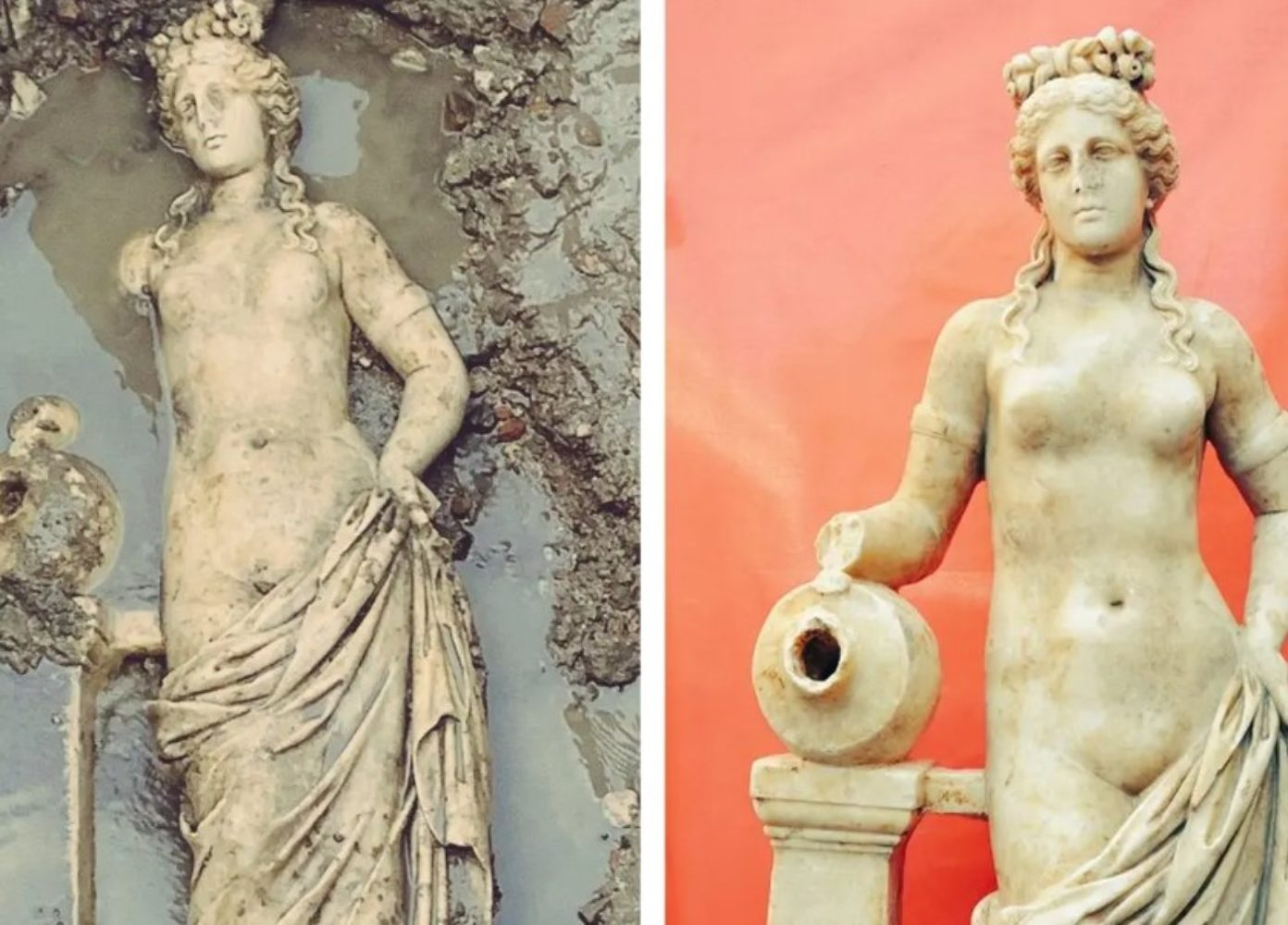
It is worth mentioning that a 1.50-meter-tall statue of Aphrodite has been discovered recently in ancient Amastris. It could be established that it is a Roman copy from between 180 and 200 AD that was inspired by Praxiteles school in the 4th century BC. The ancient city was named after Amastris, the niece of King Darius III, who married Dionysos, the tyrant of Herakleia-Pontus.

The map included in my post About Arrian’s Periplus of the Euxine Sea is most useful for locating all the cities, harbors, and rivers mentioned above. 

It should be said that while inspecting the Cappadocian frontier harbors in 123 AD, Emperor Hadrian had already visited part of the southern Euxine Sea, including Trapezus. With this in mind, Arrian now informed the emperor that Trapezus was building a new harbor, replacing the mooring where ships could only anchor in summer. 

It is quite amazing to see so much geography and history being exchanged. We tend to forget the many lines of communication that existed in antiquity, with traders, merchants, scholars, philosophers, astronomers, kings, and emperors traveling far and wide, by land and by sea.

[to be continued in Part 3]

Wednesday, October 31, 2018

The new Uşak Archaeology Museum

A few years ago, when I visited the Archaeological Museum of Ankara, I was surprised to find a gold brooch of a winged seahorse set in the spotlights, as there had been a lot of commotion about this piece, looted from a tomb in 1965 and recovered in 2013 after it was stolen again in 2005 (see: As Rich as Croesus).

To my greatest surprise, the same brooch pops up in the collection at the new Archaeology Museum in Uşak, together with 431 other artifacts from the Karun Treasures that once belonged to King Croesus of Lydia. This collection is what survives from the illegal digging at Toptepe, Ikiztepe, and Aktepe, not far from Uşak in western Turkey.

The museum was planned to open in 2013, but as always, those things are delayed. The new two-storey building houses 2,500 historical artifacts ranging from the Paleolithic Age up to the 20th century. Special reference is made to finds from the ancient cities of Acmonia and Sebaste, of which nothing else is mentioned, and this makes me wonder about their location and history. Maybe when the museum is fully functioning, more information will become available?

In their article, The Hurriyet Daily News gives a link to pictures of the museum, but their labels are lacking information. Conclusion, this is all very interesting, but at the same time very vague and in great need of more details!

Monday, July 2, 2018

Lydia and its abundance of gold

Lydia, now in modern Turkey, does not immediately ring a bell but the proverbial expression of “being as rich as Croesus” certainly will.

We have to go back to the 6th century BC when Croesus was King of Lydia, which covered all of Asia Minor west of the Halys River, except Lycia to the south. He was the last ruler to oppose Persia’s conquest of Asia Minor and their invasion of Greece. Croesus' opponent was nobody less than the powerful Cyrus the Great

While preparing for this mighty confrontation, Croesus consulted the oracle of Delphi to know what his chances were. As always, the oracle answered in an ambiguous way stating that should Croesus attack the Persians, he would destroy a great empire. He obviously believed what he wanted to believe (that he would be victorious) but the reality turned out to be just the opposite and he was defeated by Cyrus in 546 BC.

Lydia had a common border with Media which Cyrus had united with Persia, the Halys River and this is where Croesus and Cyrus met in a fierce but inconclusive fight. As winter approached, Croesus disbanded his army (a common practice in his days) but Cyrus did not and carried out another attack in Thymbria (near Troy) followed by the conclusive one in Sardes where he captured Croesus. The death of this great Lydian king is shrouded in mystery and legend. The most current theory is that Cyrus ordered him to be burned on a pyre but that Croesus somehow escaped death with a great deal of variations as to how that happened.

According to history, Croesus was the first to issue coins with a standard tenure in gold used for general circulation. However, the coins were made of electrum which was found in the alluvial deposits of the Pactolus River that ran through Sardes, the capital of Lydia. It did not take local metallurgists too long to discover how to separate gold from silver and in the process they were able to produce each metal with a high degree of purity.

After the Persian victory, gold was adopted by the Achaemenids to become the main currency for their coins, the Daric. The value of the Lydian gold and silver coins was trusted throughout the antique world, making Sardes inevitably one of the richest cities. It is no surprise that Alexander, even one century later, was most determined to conquer Sardes and its precious treasury.

Beside these precious gold/electrum mines, Lydia was also an important center for manufacturing and dying delicate woolens and carpets. It makes me wonder whether these were the ancestors of today’s carpet industry in Turkey, who knows?

Thursday, February 12, 2015

Miletus, Alexander’s first siege in Asia

While Alexander was still in Ephesos, the Persian governor of Miletus, Hegisistratus, made his appearance at the court. He came in peace, offering the surrender of the city. At that time, Miletus was the largest Greek city on the eastern shore of the Aegean Sea.

Its origins go back to Mycenaean times in the 11th century BC. In 670 BC, Miletus started colonizing the coast of the Black Sea, the Mediterranean, and the Sea of Marmara. Just like Priene and the other cities belonging to the Ionic League, Miletus suffered from repeated Persian invasions and occupations, the most memorable of which happened when Cyrus defeated Croesus of Lydia, causing the fall of Miletus. In 499 BC, however, this city led the Ionian Revolt against the Persians, punishing Miletus and destroying the mighty city, but it soon recovered.

So, by the time Alexander arrived in 334 BC, Miletus was in Persia's hands only because its excellent harbor was their main base, ideally situated to control the other cities of Asia Minor or launch a counter-attack on mainland Greece. Miletus was surrounded on three sides by the sea and had strong fortifications on the landward side. It is not surprising that Alexander welcomed Hegisistratus’ offer.

In this context, Alexander marched towards Miletus with only a small number of troops in his entourage. Yet, at the same time, news reached Hegisistratus that a 400-warship strong fleet of the Persians was only three days away. This gave the governor new hope and a good reason to resist the Macedonian king, who found the city gates closed upon arrival.

Meanwhile, Alexander’s own fleet of 160 ships commanded by Nicanor (brother of Parmenion) had anchored on the island of Lade, just off Miletus. The island was fortified with 4,000 men 4,000-man-strong garrison ready to make it difficult for the Persians to use the harbor for their operations. Consequently, the Persian fleet was forced to land off Mycale, some 15 km south of Miletus. The situation at sea seemed locked for the time being. Alexander decided to begin besieging Miletus from the land side, confident that the Persians were in no position to help or reinforce the city from the sea.

For the time being, Alexander made himself comfortable in nearby Priene and directed the siege operations from there. Here, he was approached by an unexpected embassy led by Glaucippus, a well-respected citizen of Miletus. His proposal was that Miletus would become a free city, meaning that both Persians and Macedonians could use its harbor at will. If he had accepted, Alexander would have allowed the vital port of Miletus to be open to the Persians, who had access to the entire coast of Asia Minor.

Early next morning, Alexander moved his siege engines forward, probably including his stone-throwing catapults. Artillery was used to chase the defenders from the walls, after which the battering rams and scaling ladders were brought in. The wall crumbled soon enough, and the city was quickly taken. The Greek fleet, which had positioned itself as a ring around the city, successfully prevented the Persians from giving Miletus any assistance.

Panic broke out among the citizens of Miletus, who immediately offered to surrender to Alexander. Alexander probably accepted their plea, but he slaughtered nearly all the Greek mercenaries who had defended the city from the Persians. Only about 300 of these mercenaries escaped, using their shields as makeshift rafts to paddle to safety on one of the many rocky islets off Miletus. Of course, Alexander was not going to leave it at that and mounted scaling ladders to the front of his triremes to be used by his men to land on the islet. On the other hand, the mercenaries did not ask for mercy but were prepared to fight to the death. At this point, Alexander showed clemency, and in the end, they were included in his army.

With Miletus taken, Alexander could now concentrate on eliminating the threat of the Persian fleet. He did not want to get involved in a naval battle because his fleet was much smaller, and the men on board were not trained in maritime warfare. Instead, he sent Philotas by land to Mycale, preventing the Persians from landing and getting new provisions and fresh water from the River Maeander. The fleet withdrew, seeking protection on the island of Samos instead. Eventually, the Persian fleet moved south to the safety of Halicarnassus, which was still in Persian hands.

This being settled, Alexander elected a democratic leader, canceled all taxes, and boosted commerce – in short, he started a new period of prosperity for Miletus. This prosperity ended with the arrival of the Romans in 133 BC, who imposed high taxes now that the city was part of their Provincia Asia. By the third century AD, Miletus’ decline set in as its harbors silted up and marshes were formed.

Today, the antique city is to be found 10 km inland, and in springtime, the once so busy port is covered by extensive marshlands filled with reed and blooming irises. In a way, this helps to imagine what this vast harbor must have looked like. The old rotunda was part of the Harbor Monument built in honor of Pompey in 31 BC, still surrounded by water. This Monument must have been at least 7.5 meters high and may have carried a big iron pot on top, part of which is now on display at the Pergamon Museum in Berlin. Maybe, after all, it was a beacon? Although the marshes are omnipresent in springtime, the land is dry in autumn, meaning that the visitor gets quite a different view of Miletus in either season.

In historical literature, Miletus is described as less impressive than Priene, but I think that is somewhat cliché, for it is just different.

The most striking building is the theater sitting on the hilltop, commanding the entire city of Miletus. It is one of the most splendid constructions one can imagine, not only because of the many tiers of seats that have been so well preserved but also because of the entrance gates and the near-intact vaulted corridors. This theater clearly illustrates the high level of architecture reached by the Romans; the very concept of theater is highly efficient. Easy walking steps take the visitor to the cool entrails with fascinating views over the surrounding landscape and the interior of the theater itself. The first theater was evidently Greek, built in the 4th century BC, and counted approximately 5,300 seats; the Romans extended it in the 2nd century AD to hold 25,000 people. The façade is impressive enough, 140 meters long and 30 meters high. It is hard to imagine this theater's full impact since the upper tiers' stones have been taken to build the Byzantine church on top, leaving a mere seating space for 15,000 people.

From up here, one can easily see the layout of the entire city. Following the marshy water line from the harbor, I find the Delphinium, the open-air Temple of Apollo Delphinius, the protector of the seafarers and the ships. The four remaining columns of the Ionic Stoa next to it quietly reflect their image in the still waters covering the North Agora. Sitting in the shadow of these columns, I discover an ancient graffiti of a fish and the Greek word IΧΘΥΣ, both symbols that were used by early Christians – what a rewarding moment!

The remains of the adjacent Hellenistic Gymnasium are relatively poor, and the colossal Nymphaeum from the 2nd century AD flanking it on the other side requires lots of imagination to picture it. Across from the Nymphaeum are the remains of the Bouleuterion, built between 175 and 164 BC. But here, as elsewhere, the parts belonging to the Hellenistic period blend in very harmoniously with those added later by the Romans.

Further south, past the South Agora, the Baths of Faustina, Marcus Aurelius wife, are visible; rough brick arches and walls don’t do justice to the once so great building whose ornamental statues are now in the Archaeological Museum of Istanbul. These baths date from 43 AD, and I’m not surprised to hear that they served as a role model for the Turkish baths, the hammam. This South Agora, belonging to the 2nd century AD, measures an impressive 196x164 meters and must have been impressive. The southern entrance gate to this Agora has been entirely moved and reconstructed at the Pergamon Museum in Berlin (unfortunately, it was under restoration when I visited the museum).

It certainly is worthwhile to visit Miletus in spring and again in fall when the water level has receded, and the Agoras show their large slabs of marble flooring. At that time, the outline of the different buildings was much more recognizable, which truly helped to get a comprehensive view of the city.


Between the Baths of Faustina and the South Agora lies the Temple of Serapis from the 3rd century AD. Not much is left except the re-erected pediment showing a relief of the god Helios Serapis wearing a crown of sun rays. The rectangular buildings seen on the right-hand side are warehouses.

That brings me to the most exciting location in Miletus, the Sacred Road that led all the way to Didyma, the city renowned for its oracle. The first road dates back to at least the 6th century BC, but it has been improved and embellished over the centuries. In 100 and 101 AD, Emperor Trajan, for instance, raised the road level and made the necessary repairs. From the early days onward, this Sacred Road was lined with statues of the Branchidae (priests and priestesses attached to the temple of Didyma); crouching lions and sphinxes; votive fountains; and even monumental tombs and sarcophagi belonging to important persons. None of these features is to be seen anymore since all were moved to the British Museum in London, the Archaeological Museum in Istanbul, or the local Museum of Miletus. This 16.5-kilometer-long road was entirely paved and had a width of 5 to 7 meters. Both in Miletus and in Didyma, it is still pretty easy to locate a sizable stretch of this Sacred Road; just have a close look. I was so lucky to be put on the right track by Peter Sommer during my travel on his tour "In the Footsteps of Alexander the Great" - a most rewarding experience! 

I have not found any indication about the road used by Alexander on his way from Miletus to Didyma, but it is rather evident that he would have followed this Sacred Road. For me, this is another place where Alexander’s presence is still tangible. 

[Click here for more pictures of Miletus]

Monday, January 19, 2015

Ancient Turkey. A Travellers’ History by Seton Lloyd

Seton Lloyd is one of those rare authors able to tell a lot in a few words while not giving the impression of bombarding his readers with facts and figures.

Ancient Turkey. A Travellers’ History (ISBN 9780520220423) gives a lively overview of Turkey’s rich history from prehistoric times up to Christianity, covering the country's occupation by the Hittites, Phrygians, Persians, Greeks, and Romans.

This book is handily divided into concise chapters sharing just enough details about each ruling power to keep you reading. You’ll find good basic information about the enigmatic Hittites in Central Anatolia; the mysterious Trojans; the power of King Midas and the wealth of King Croesus; the occupation by the Persians including Xenophon's journey of the Ten Thousand; the rise of Macedonia leading to the conquests of Alexander the Great and the spreading of Hellenism; the Roman Power and the legacy of Augustus; concluding with early Christianity in the footsteps of St Paul. Quite a chunk of history is presented in a very comprehensible way.

Seton Lloyd has added several unique pictures, many of them from the days of early excavations, which make them interesting to those who are more familiar with these major archaeological sites.

This is an excellent reference book that can be consulted for any time period of the rich history of Turkey.

Wednesday, June 19, 2013

As Rich as Croesus

The wealth of King Croesus has become proverbial, and still today, more than 2,500 years later, we all know the expression “to be as rich as Croesus”. But who was Croesus? When and where did he live? And was he really that rich? These questions arise after the latest news that a gold brooch from his treasure is returning to Turkey.


But first, the brooch story. The piece is a winged seahorse looted from tombs in Western Turkey in 1965, which by the 1980s found its way to the Metropolitan Museum in New York. In 1993, the brooch came home as a showpiece at Uşak’s Museum, but the good news didn’t last, as in 2006, thanks to an anonymous tip, it was discovered that the brooch on display was a fake. What had happened?

An investigation revealed that the director of the museum had accumulated serious debts by gambling and couldn’t think of a better solution than to sell this famous brooch, together with other artifacts. Now, the brooch itself is said to be cursed since ancient times, meaning that whoever touched it would meet misfortune or even death. This might explain the strange behaviour of said director.

Luckily, the original brooch could be traced back to Germany, and the Turkish Minister of Culture has meanwhile confirmed that the precious piece will soon return home. Home is the Archaeological Museum in Uşak that will be housed in a new building and is expected to open its doors by the end of 2013 to show off the four hundred and fifty pieces from Croesus’ treasure (also known as the Karun Treasure) – that is, if the curse is broken!

The news made headlines, of course, although it has not been determined whether the artifacts ever belonged to Croesus.  However, it is generally accepted that they are from about the same period. The largest part of the Croesus treasure seems to come from a tomb chamber belonging to a Lydian princess that was blasted by looters in the 1960s to gain access. Later on, looters added other precious items from neighboring tombs to the collection.

King Croesus (born about 595 BC) ruled over Lydia (in Asia Minor, today’s northwestern Turkey) from 560 to 546 BC when he was defeated by the Persians. He is known to have ended the old wars with the Greeks and taken possession of Aeolia and Ionia. He failed to occupy Miletus but established his authority in Ephesos, where he rebuilt the famous Temple of Artemis, something he could easily afford as his court is said to have lived in splendid luxury. Yet, the relationship with Ionia was an uneasy one, especially since he was pressed by the Persians, who gained ever more power in Anatolia. It must be said that the Persian King at that time was nobody less than Cyrus the Great – later to be a raw model for Alexander the Great! Cyrus was an enemy to be reckoned with, and so Croesus consulted the oracles of both Delphi and Amphiarion. The responses from the oracles went down into history, for they were typically double-sided: if Croesus attacked the Persians, he would destroy a great empire. Croesus evidently thought he would conquer the Persians, while in the end the Persians came out victorious, taking the Lydian capital city of Sardes and Croesus.

It is important to know that Croesus was the first king to issue gold coins with a standard purity. In fact, they were made of electrum, a natural alloy of gold and silver that was found in the alluvial deposits of the Pactolus River running through Sardes. It is after Croesus’ defeat that the first gold coins appeared in Persia.

Tuesday, May 14, 2013

Pamphylia, generally the area around Antalya

Even in antiquity, the borders of Pamphylia were difficult to establish accurately. It roughly starts in the west, where Lycia stops and covers the plains north and east of Antalya up to the foothills of the Taurus Mountains. The cities in my field of interest generally lie within its borders: Antalya, Perge, Sillyum, Aspendos, and Side, while Termessos and Selge belong to Pisidia, situated to the north, together with Sagalassos.

In as much as it was traceable, the Pamphylian language is a Greek dialect spoken in southern Greece, moving to Asia Minor with its emigrants who arrived here before 1100 BC. Proof of this dialect can be found in an inscription from Sillyum. On the other hand, strangely enough, the people of Side spoke a dialect of their own that had yet to be deciphered.

The history of Pamphylia is somewhat confusing. We have to wait till the 6th century BC when King Croesus of Lydia annexed this territory. However, his rule was short-lived because, in 546 BC, he was already defeated by the Persian
King Cyrus. During the following centuries, Pamphylia was occupied in turns by the Athenians and the Persians until, in 386 BC, a treaty of peace was finally signed by both powers, giving the cities of Asia Minor to the Great Persian King. The yoke of Persian rule was not heavy, and Pamphylia settled quickly.

The situation changed in 333 BC when Alexander entered Pamphylia from Phaselis in Lycia after his march along the coast. His first stop was Perge (Antalya did not exist yet), where he received a delegation from Aspendos, who surrendered their city, provided Alexander did not leave a garrison behind. Alexander generously agrees, but in exchange, he demands fifty talents to pay his army and deliver as many horses as they usually give to the Persian King.

Aspendos accepts, and Alexander moves on to Side, where he meets no resistance. He leaves a garrison behind and returns westwards to Sillyum, which turns out to be the first Pamphylian city to resist. Whoever has ever seen Sillyum (modern Sillyon) will quickly realize that the town is a practically impregnable fortress high on a trapezoidal hilltop in the middle of the plain. As can be expected, Alexander attacks, without success, though. Before he can conceive a second plan, the news reaches him that the people of Aspendos have changed their minds and have decided not to respect the freshly signed treaty. Catapults are dismantled, and Alexander wasted no time marching his army immediately back to Aspendos. This fast reaction was not what Aspendos anticipated, and their previous promises were hastily reconfirmed. Alexander was not keen to start a siege of the strongly defended city. So he agreed, claiming, however, an extra fifty talents, several hostages, and a yearly contribution to be paid to Macedonia. No joking!

Alexander then returned to Perge and conceived plans to push northwards to meet up with his general Parmenion and the rest of his army, which had spent the winter in Gordion. For unclear reasons, Alexander is made to believe that the only road to Gordion passes through the strategic city of Termessos, which commanded a very narrow mountain pass, a sort of Thermopylae. While Alexander was preparing for the attack, a peace delegation from Selge reached him. What exactly has been said remains a mystery. Still, they pointed out that there was indeed a much easier road north, the one that corresponds to the modern main road from Antalya to Sagalassos. The entire attack of Termessos was called off, of course, and Alexander led his army to Sagalassos.
 
After Alexander died in 323 BC, his generals fought and bickered over the territory of Pamphylia, which fell successively under the rule of Greece and Macedonia, then of Egypt under the Ptolemys, and finally under the Seleucids of Syria. By 280 BC, the Seleucid branch of Pergamon was taking over with kings who all went by the name of Attalus or Eumenes. The Romans appear but are in no mood to worry about this part of the world and leave things in the hands of Pergamon. This dynasty ended in 133 BC when Attalus III, the last king of Pergamon, simply donated his kingdom to Rome. But Rome showed little or no interest until they were forced to interfere because of the heavy piracy along the coast of Asia Minor. Solving this problem was not easy. The first success was booked by Servilius Vatia in 78 BC, but Emperor Pompey finalized the job in 67 BC. 


During the days of the Roman Empire, Pamphylian cities received more freedom, especially Aspendos, Perge, Sillyum, and Side. In the year 43 AD, the region was once more joined to Lycia and remained so until the fourth century. The Byzantine Emperors organized and reorganized Asia Minor over and over until Lycia and Pamphylia became once again independent provinces. Later on, it was the turn of the Arabs to take possession of Pamphylia, followed by the Crusaders, until finally, it was absorbed by the Ottoman Empire.  

This is a corner of Turkey I want to investigate further since it plays a significant part in Alexander's conquests eastwards. Walking in the great man's footsteps always is an honor and a privilege, and I'm very excited to see all these fascinating places with my own eyes. Besides the usual Alexander historians, I am relying on the precision work of George Bean with his Turkey's Southern Coast and on the handy maps and itineraries from the Sunflower Guide, From Antalya to Demre.   Alexander, here I come!

[Click here to see all the pictures of Pamphylia]

Monday, August 20, 2012

An introduction to Caria, Turkey

It is quite amazing to realize how little we know about the ancient regions of Turkey. In Greece, we are quite familiar with Attica and Macedonia, for instance, but in Turkey, that knowledge is still very remote. Ask any of the millions of tourists who flock to Antalya each year and close to none will be able to tell you that they actually are in ancient Pamphylia.

Well, I have been among those ignorant travelers for years, I must admit, as it is only since I intensively followed the trail of Alexander the Great after crossing the Hellespont (modern Dardanelles) that I became aware of the distinctive areas. They slowly fell into place: the Phrygians with their typical hats, the Lydians with King Croesus, and mostly Ionia with cities like Ephesus, Priene, and Miletus. So my puddle of awareness slowly grew as I marched alongside Alexander the Great to the East.

This time, I find myself in ancient Caria, where Halicarnassus (modern Bodrum) once shone with its famous Mausoleum, one of the Seven Wonders of the Ancient World. However, unlike the situation in our modern times, clear borderlines generally did not exist, and the limits of these more or less independent regions were rather vague. At times, a river or a mountain range may have defined the limit, but otherwise, many border towns were often alternatively ruled by the strongest ruler on either side.

In any case, although I had visited several inland cities in southwestern Turkey that belonged to Caria, I still had no clear image. Caria remained an abstract region. Strange, to say the least.

It is generally accepted that Caria covered the area from the Meander River in the North to today’s Lake Köyceğiz above Caunos in the South. The Carians, curiously enough, do not fit in with their neighbors in any way, neither culturally nor linguistically. There are many theories about their origin, but as they say themselves, they have always lived on the mainland and have always been called Carians. Homer in his Iliad mentions that they were “barbarous of speech” and it seems that even today’s Turkish in that region is labeled as being “harsh”. They were excellent seafarers, though serving in many foreign armies, and were, for instance, highly prized (and probably well paid) by the Egyptians. It is said that it was the Carians who taught the Greeks to put crests on their helmets and showed them how to affix handles on their shields, which, till then, were simply slung over the soldier’s shoulder.

Caria’s greatest ruler certainly was Mausolus, who lent his name to the word “mausoleum” after the tomb he built for himself. This is definitely a “must-see” for every visitor, yet what is left is a very disappointing sight, I would say. The ancient Mausoleum stood in the very heart of the city, but today’s site looks more like a bomb crater amidst the low houses. I thoroughly admire the efforts of historians and archaeologists to bring these unique remains back to life, but it is asking a great deal of our imagination to picture this once so grandiose building on this spot. What is left here are only crumbs. For twenty centuries, the Mausoleum withstood many wars and natural disasters, but the repeated earthquakes turned out to be fatal, and when the Knights of Rhodes arrived here in 1402, they found ready building material for the construction of their fortified castle, the very one that we call St John’s Fort in the middle of the harbor. The story goes that the Knights still found an untouched coffin in the base of the Mausoleum, but postponed opening it till the next day. Yet the next day, the tomb had been plundered. It is said that both Mausolus and his wife Artemisia were cremated, meaning that there could only have been an urn with their cremated remains, but that is something we will never know for sure. The Knights were kind enough to save some of the friezes that were lying around and used them to decorate the walls of said castle. This is where the British archaeologist, Charles Newton, found them in the mid-19th century to recover them and ship them to the British Museum, together with part of a wheel (two meters in diameter) from the quadriga on top of the Mausoleum and the statues of King Mausolus and Queen Artemisia. In a later shipment, he loaded the blocks of marble and green stones that were to be transhipped in Malta. This load, however, never left the Maltese docks because the stones were considered of less importance and amazingly enough, they were used in the construction of the city’s new docks in the 19th century (see Remains of the Mausoleum of Halicarnassus in Malta?).

Despite all the efforts made in recent decades, we are still not entirely sure what the Mausoleum really looked like. Although we have detailed descriptions from witnesses like Pliny and Vitruvius, they don’t give a good overall view, yet plenty of facts and figures to go by. The fact is that the most talented artists of that time were called upon. Skopas, Leochares (the same architect who built the famous Philippeon in Olympia for Alexander’s father!), Bryaxis, and Timotheus were appointed to decorate one side of the Mausoleum each, assisted of course by hundreds of craftsmen of all kinds. The Mausoleum is said to have been 148 feet high, resting on a square base with a stairway leading to the first platform. The outer wall of that platform was decorated with statues of gods and goddesses, while on each corner, a warrior on horseback was guarding the tomb. On top of this platform stood an imposing square mass which was girded with a band of reliefs representing the battle of centaurs and Amazons with Greek soldiers. This section was then crowned by 36 columns, alternated with more statues, behind which a massive block supported the pyramidal roof, where the quadriga with Mausolus and Artemisia was placed. During my last visit, it suddenly dawned on me that this Mausoleum has, in fact, close ties with the Pyramids in Egypt, as in both cases the actual tomb is hidden deep inside a massive stone construction.

Except for a few dozen lost blocks and column drums, nothing significant is left on the spot to see, with one single frieze that found shelter in the small museum next to the very ruins. For those who are really interested, it is worthwhile to take a closer look at St John’s Castle itself to locate the recuperated stones and column drums from the ancient Mausoleum in its walls. Finally, I would highly recommend a visit to the British Museum in London, to admire the magnificent statues of Mausolus and Artemisia, the horse head with its iron bit still in place, the lions that once watched over the lower staircase, and, of course, the many friezes created by the four great artists, were it only to make the (mental) picture complete.

Click on the Label Caria 2012 to read the full story