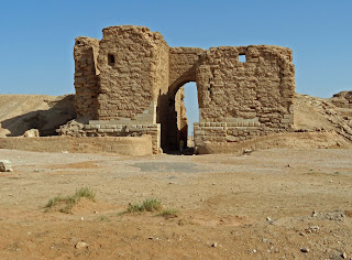
Alexandria's founded by Alexander

Alexandria's founded by Alexander the Great (by year BC): 334 Alexandria in Troia (Turkey) - 333 Alexandria at Issus/Alexandrette (Iskenderun, Turkey) - 332 Alexandria of Caria/by the Latmos (Alinda, Turkey) - 331 Alexandria Mygdoniae - 331 Alexandria (Egypt) - 330 Alexandria Ariana (Herat, Afghanistan) - 330 Alexandria of the Prophthasia/in Dragiana/Phrada (Farah, Afghanistan) - 330 Alexandria in Arachosia (Kandahar, Afghanistan) - 330 Alexandria in the Caucasus (Begram, Afghanistan) - 329 Alexandria of the Paropanisades (Ghazni, Afghanistan) - 329 Alexandria Eschate or Ultima (Khodjend, Tajikistan) - 329 Alexandria on the Oxus (Termez, Afghanistan) - 328 Alexandria in Margiana (Merv, Turkmenistan) - 326 Alexandria Nicaea (on the Hydaspes, India) - 326 Alexandria Bucephala (on the Hydaspes, India) - 325 Alexandria Sogdia - 325 Alexandria Oreitide - 325 Alexandria in Opiene / Alexandria on the Indus (confluence of Indus & Acesines, India) - 325 Alexandria Rambacia (Bela, Pakistan) - 325 Alexandria Xylinepolis (Patala, India) - 325 Alexandria in Carminia (Gulashkird, Iran) - 324 Alexandria-on-the-Tigris/Antiochia-in-Susiana/Charax (Spasinou Charax on the Tigris, Iraq) - ?Alexandria of Carmahle? (Kahnu)
Showing posts with label Halabia. Show all posts

Monday, October 24, 2016

Tracking Alexander from Tyre to the Euphrates

When reading any of the Alexander histories, the routes he followed seem to be clear-cut and leave no room for any doubt at all – that is until we actually try to walk in his steps with a map in hand. Many stretches are quite obscure while others are, let’s say, not too obvious. Historians have a tendency to stick to the facts and when nothing noteworthy is happening between point A and point Z, they simply skip every step or stop in between. This is the case when Alexander leaves Tyre for Thapsacus and Arrian simply states that he marches “inland”; a straightforward route until you try to figure it out.

In antiquity, the traveler would generally follow rivers, skirt mountains and deserts, look for arable lands able to provide enough food, and spot wells for drinking water when there is no river on the way. When this is not possible, one has to be inventive. A good example of such creativity is, for instance, when Alexander has his fleet accompanying him along the desert of the Sinai; another one when he returns from Egypt to Tyre and where his army had widely depleted the rare agricultural provisions on their way south a few months earlier and he made use of his fleet once again.

From Tyre, scholars are generally torn between two possible routes leading the army inland. The first would retrace Alexander’s steps north to near Antioch-on-the Orontes along the coastline and from there turn east towards the Euphrates as Cyrus the Younger and Crassus had done, using the fleet to support his provisions. The other possible road, which I prefer because the region was more fertile in antiquity, runs east to Damascus and from there north to Homs, Hama, Apamea, and Aleppo. Or, after all, Alexander may have used a combination of both routes – why not?

Damascus is incontestably the oldest inhabited city in the world and against all odds, I am looking for traces of Alexander but find none. That is not surprising since he only passed through the city in 331 BC; there was no siege or resistance apparently. In fact, there is nothing left that could refer to Hellenistic times, as all traces generally have been erased and supplanted by Roman constructions anyway. The Romans, however, used Greek and Aramaic foundations when they laid-out Damascus, covering an area of approximately 1,500 x 750 meters, inside its protective walls. Damascus counted seven city gates, but only the Bab Sharqi on the east side has survived. This city has been discussed in detail in my earlier blog, Damascus after Alexander.

Even the modern road north from Damascus skirts the eastern flanks of the Lebanon Mountains. The countryside looks uninviting and a pretty barren stretch of some 200 kilometers that Alexander must have tackled stubbornly as always, although the land may have been more fertile in his days.

Beyond Homs, he must have aimed for Hama which lies on the Orontes River and is today one of the largest cities in Syria after Aleppo, Damascus and Homs and an obvious stop for anyone traveling between Damascus and Aleppo. Under Hellenistic rule, the city prospered since it laid on the trade routes between Greece and Asia. Hama is best known for its spectacular large wooden waterwheels – a Roman/Byzantine invention so ingenious that you have to see them in order to fully grasp their significance (see: Hama and its ingenious norias). Known under their Arabian name as norias, their earliest traces are found in a mosaic dating from 469 AD but they may have been used earlier on.

From Hama, the modern road heads straight for Aleppo without being hampered by the desert but Alexander must have stayed closer to the floodplains of the fertile Orontes River for the first stretch of his route at least and would, inevitably, have come to Apamea (see: Apamea, heritage of Alexander).

Leaving Apamea, Alexander must have veered to the northeast across a mostly desert landscape to reach Aleppo, almost one hundred kilometers away. It is not impossible that previously to his march, he organized water depots along the way.

The modern city of Aleppo has been built right on top of its antique remains, meaning that there is very little to see from when Alexander was here in 331 BC. His successor, Seleucos called it Beroea in memory of the city by the same name in Macedonia. It became the center of gravity of the Hellenistic colonization till it was conquered as the rest of Syria by Pompey in 64 BC.

The most striking feature in Aleppo is unmistakably its Citadel situated at the center of the old city that was surrounded by a five kilometres-long wall counting seven entrance gates. To my knowledge, no Greek/Hellenistic remains have been uncovered although excavations have reached the layers of the neo-Hittite period. Yet it seems that friezes belonging to a temple dedicated to the god of storm Hadad dating from the third millennium BC have been discovered.

This partially manmade hill that is crowned by the famous Citadel rises some fifty meters above the city and measures respectively 450 and 325 meters across since it has an elliptical shape. Originally the entire hill was covered with large blocks of whitish limestone that were very difficult to climb; some of these slabs are still in situ. The mound is surrounded by a moat, 22 meters deep and 30 meters wide, which has been added in the 12th century. The inside of the Citadel is a town on its own with a hammam, a number of mosques, a palace occupied by the sons of Saladin and even a theater that is still being used. All this is obviously a very far cry from what Alexander may have found, but the panoramic view over the roofs of Aleppo cannot have been too much different, except for the presence of minarets and mosques.

Alexander arrived at Thapsacus by mid-summer 331 BC and had two (pontoon) bridges constructed over the Euphrates which, according to historians was a good 700 meters wide at this spot. There have been endless discussions about the location of this city, which has been placed at Al Raqqa, Dura-Europos and even at Deir-Ezzor further downstream. Based on the facts related by Xenophon and Eratosthenes, however, all evidence points towards Carchemish on the Turkish-Syrian border. It seems that, except for a few towering walls, there is very little left of old Thapsacus because after the construction of yet another dam the river has turned into a lake and the scant remains are nothing more than an island in the middle of the Euphrates. It is so sad to find such a historical place swallowed by the waters after centuries of survival!

It so happened that my first view of the Euphrates River was near Birecik, Turkey, on the road from Gaziantep to Sanliurfa, i.e. about 30 kilometers north of the place that has been identified as Thapsacus. Crossing this majestic, wide, blue and fast flowing river over a modern bridge, confirmed that I was truly entering Mesopotamia, the land between Euphrates and Tigris from my history books. The depiction of this being the Fertile Crescent eludes me, for the land is desolate and barren and the houses on the eastern river bank are nothing more than square colored blocks piled up against a sandy hill.

Based on Darius’ earlier crossing of the Euphrates before the Battle of Issus, it may have taken Alexander five days to move his entire force to the eastern bank. The logistics of such an operation are never discussed in detail, neither here nor at any other major river like the Nile, the Tigris, the Oxus, the Jaxartes or the Indus for that matter, but the operations much have been colossal and terribly well organized!

The modern flow of the Euphrates cannot be compared to what it was in Alexander’s days, mainly because of the many barrages that interfere, but it remains a very rewarding experience to follow the river further downstream along the Lake of al-Assad to Rasaffa, Al-Raqqa, Halabia, Deir Ezzor and finally to Dura-Europos. These basically were all Roman forts at the edge of the empire but most probably were first settled by Seleucos a few decennia earlier. Contemplating the river from among the reed fields in the near silence on an early winter evening was one of my greatest experiences. In the tiny villages in between, time has come to a standstill.

Another memorable moment was at Halabia where I climbed up to the remains of a Roman fort. From this strategic location, I could look up and down the Euphrates beneath me as the soldiers had done some 2,000 years ago. From this vantage point, I was reminded of Alexander when the occasional car crossed the rickety pontoon bridge with a resonating sound in the quiet evening air. History was simply unfolding at my feet! I was wishfully thinking to look for Thapsacus around there. 

Wednesday, July 24, 2013

Dura Europos, last stop on the Euphrates

After Deir Ezzor, Rasaffa, and Halabia, I am heading for Dura EuroposSyria's most southeastern frontier garrison on the Euphrates. The landscape is as barren as the northeastern desert corner of Jordan, and it is hard to imagine that Mesopotamia once was so fertile and consequently so prosperous. Instead, I suddenly see a row of sand dunes, but so straight that they must be manmade. And they are, for these are drift-sands that accumulated against the walls of Dura Europosthe only original Hellenistic fort in the abovementioned series. Approaching from the land side, it is not apparent to appreciate the unique location as the Euphrates only reveals itself once you have penetrated the very heart of the city.

Like Apamea and Deir Ezzorit was founded around 303 BC by Seleucos. He wanted to build a reliable control post on the Euphrates and new trade routes with his recently founded cities of Antioch-on-the-Orontes and Seleucia-on-the-Tigris. He must have remembered the lessons of his master, Alexander.


Being Hellenistic, it is no surprise that Dura Europos is set up according to the Hippodamian plan with right-angled streets around the large central Agora. The Parthians conquered the city by the end of the second century BC. They stayed till the arrival of the Romans in 165 AD. People of different origins lived in Dura Europos, as testified by papyri and parchment inscribed in Greek, Latin, Aramean, Hebrew, Syriac, the language of Hatra, Palmyrene, Persian, and Pahlavi. But it is mainly the Macedonians who left their indelible imprint on this place.

The main entrance is through the Palmyra Gate, which, although only partially preserved, gives an excellent idea of how this stronghold was conceived. The surrounding massive nine-meter-high ramparts are interrupted by a series of defense towers built, like in Halabia, with the same pink crystal-like gypsum. But it is difficult to get a good overall picture of the site since most of the city is half-buried under the sands. However, on the far left is where the Roman military camp from the third century is located, complete with the commander's palace. 

Following the main street in the direction of the Euphrates, I am pointed to the right, where most of the sixteen temples were situated, worshiped by Christians and pagans alike. The oldest synagogue of Jewish origin is among them, dating according to Aramean inscriptions to 244 AD. Every inch of its walls and ceiling were covered with wonderfully well-preserved frescoes depicting scenes of the Last Judgment. Men and animals from the oldest bible stories are illustrated with vivid images and colorful pictures. The inside of this synagogue has been entirely dismantled and moved to the Archaeological Museum of Damascus, which is worth a visit if only for this synagogue!

Besides the synagogue, there are temples dedicated to Mithras, Baal, and Adonis, proof that Jews, Christians, and pagans lived together in this multicultural city. The first traces of the Mithras Temple go back to the period 168-171, i.e., Roman times. Still, the wall paintings clearly show Parthian influences because Mithras wears Parthian trousers, boots, and a pointed bonnet. It is known that, although the Mithras cult originated in Iran, this God was very popular with the Romans. More exciting finds were made in other buildings, like mural frescos, inscriptions, military outfits such as painted wooden shields, and a complete horse harness, also exhibited at the Museum of Damascus.

 At the bottom of these temples, a small museum has been set up. Although the best pieces are in DamascusI am happy to see the mural marriage ceremony with priests wearing their funny-looking Phrygian hats – a copy of the original in Damascus. Here, at least, I am allowed to take a picture! Interestingly, the graffiti from the Palmyra Gate helps to better understand the real one.

A last attempt to save Dura Europos was made during the siege of the Persian Sassanids led by King Shapur I in the year 256. The local museum proudly exhibits a copy of a relief from Bishapur, Iran, portraying Shapur in state riding his horse - a man with presence. During the siege, he devised a masterly strategy when he dug tunnels underneath the city walls to undermine them. In a desperate attempt to increase their survival chances, the Romans immediately filled all the buildings and spaces behind the city walls with sand to reinforce them. At the same time, they worked with might and main to fill up the Sassanid tunnels underneath, but there were simply too many corridors and ramifications, leading to the ultimate defeat of the Romans. This is how Shapur conquered Dura EuroposHe razed the city to the ground and sold its population as slaves. Part of the destroyed walls is still visible in the southwest corner. However, many survived since the Romans had choked all the buildings close to the walls with sand. Among them was the synagogue with its famous frescoes.


Dura Europos was never rebuilt and disappeared from history until it was rediscovered in 1920. Serious excavations started in 1932 when said frescoes from the synagogue were brought to light. It is pretty unique that the wall paintings display animals and people, together with a Torah shrine on the western wall, i.e., the direction of Jerusalem.

Close to the Euphrates, one cannot miss the elongated remains of the fine Seleucid Citadelstrategically set on its own outcrop, guarding the bend in the river. Such great builders! 

Walking back to the Palmyra Gate, I recognize a square Bouleuterion, but the only information I can find mentions a Baptistery on this spot; this square is supposed to be a shallow pool used by Christian believers to be baptized. The public was evidently seated on the tiers around the basin.

 And then, in January 2009,  
Dura Europos made the headlines as new research confirmed that during the Persian invasion, poison gas had been used for the first time in history against the Roman defenders. This conclusion was made based on twenty Roman soldier remains at the foot of the city walls. Analysis showed the product was a mixture of bitumen and sulfur crystals set afire. The gases were directed toward the enemy using several bellows and underground chimneys. Previous speculations about this technique existed, for instance, with the Spartans during the Peloponnese War (400 BC) and from Chinese texts about warfare (500 BC). Still, the theory has just been proven. Quite unbelievable, isn't it?

Thursday, June 6, 2013

Halabiya on the Euphrates

To see the Euphrates is one of those lifetime experiences that leave a deep impression. For me, the very name is forever associated with the Bible and visions of old Mesopotamia, the land of milk and honey, and, of course, with Alexander the Great.

Unlike my previous trip when I crossed the famous river by bus over a modern bridge, I now have the opportunity to take a much closer look. The late wintry sun stands low above the horizon, wrapping the entire landscape in gold adding a touch of indescribably mystical to the Euphrates. And then there is the omnipresent silence. All I hear is the murmur of the current and the sweet rustle of the wind through the high reeds. The picture is timeless, eternal even. For me, a moment to let my thoughts drift back to Alexander the Great who crossed this very river with his army on the way to his confrontation with King Darius at Gaugamela to conquer Persia. I venture through the high grasses, carefully avoiding the marshy edges to get as close as possible to the fast-flowing water that reflects the moods of the sky and the riverbanks. I deeply savor the moment before boarding my van and driving down the winding road alongside the river.

The villages and settlements I encounter are from another world with houses assembled from large blocks of cement; cube-shaped piles of harvested cotton secured under patches of tarp; a lonely donkey tied to a pole; women carrying bushels of dried cotton stalks on their heads (fodder for the sheep); etc.  In what appears to be the heart of the settlement, hollow square rooms line the street where shops are set up displaying their colorful wares on the sidewalk: bananas, leek, oranges, potatoes, lemons, cauliflower, tomatoes, and all kinds of fresh herbs. Even the bakery shows off his bread and buns for everyone to see. Further down, stacks of crates filled with soft drinks; plastic jugs and tubs; brooms and cleaning products; drying racks for clothes; shoes, and slippers are waiting for potential customers. Men pass by on bikes, mopeds, and scooters in all possible shapes and sizes enhanced with the strangest accessories. The women’s dresses are more colorful than in the West, more like what I have seen in eastern Turkey. The taxi ahead of me is crammed with six men in black wearing their typical red-and-white scarf around their heads. The local vans, comparable to the Turkish dolmuş, seem to take more people on board than there are seats. This local folklore is very welcome for otherwise the road is rather uneventful.


In fact, I’m on my way to Halabiye, old Halabia, one of those garrisons founded by Queen Zenobia of Palmyra in 266 AD.  Time is of the essence in the fast failing daylight. Except for the sturdy city walls, there isn’t much left to see of Halabiya, only the Pretorium which occupies a very strategic place high above the Euphrates valley. The old city was located on the Silk Road and flourished till 273 AD when Emperor Aurelius added the city to the Roman Empire. However, Emperor Justinian (527-565) judged it useful to restore the city and built these mighty defense walls to withstand possible invasions from the Persians.

It is a strenuous climb up to the Pretorium and a run against the failing daylight but I’m determined to make it in time. It is hard to believe that these remains are at least 1,500 years old. The strong walls are cracked in many places due to repeated earthquakes in the area which the three-stories-high arched rooms have survived. Deep niches around arch-shaped windows remind me of Medieval castles and look in fact quite cozy with a stone bench on either side that may have been covered with some cushions or covers. This is a great spot for the lookout to scrutinize the river upstream as well as downstream. The quietness of the late evening is disturbed by a rattling sound, that of a car crossing the Euphrates a few hundred meters away using a pontoon bridge – a system that was very well-known in antiquity and used repeatedly by Alexander on his march east.

It feels as if I’m looking over Alexander’s shoulder, a special glance into the past.

[Click here for more pictures taken along the Euphrates

Thursday, March 28, 2013

Zeugma, Border-town along the Euphrates River

Looking at the map of Syria, it is undeniable that most of its cities are concentrated in the west, along or close to the Mediterranean Sea. As soon as we turn to the east, the landscape becomes pretty desolate until we reach the Euphrates River, where a narrow stretch of land on either side is cultivated thanks to irrigation. The only road here follows the river's bends, dotted with occasional settlements frozen in a timeless time.

The Romans handily used the river as a natural frontier and built an entire string of forts in the style of the “limes” along the Rhine River, the Arabic Limes. They needed them as protection against possible invasions, mainly by the Sassanids from Persia. Looking at the map, we find a succession of towns and strongholds erected on the Euphrates River's western bank. Starting upstream, I read names like Zeugma, Hierapolis, Barablissos (on Lake Assad), Sura (where the Euphrates turns east), Rasaffa, Halabiye, Dura Europos, all the way down to Babylon in today’s Iraq. I think it is worthwhile to take a closer look at these names to see what they stand for and what heritage they have left for us.

Although there may have been some kind of fort at this location, it is generally agreed that Zeugma was founded by Seleucos I Nicator, one of Alexander’s generals, in 300 BC under the name of Seleucia-on-the-Euphrates. It was a strategic location on the trade route to the east connecting Antioch-on-the-Orontes with China. In 64 BC, this prosperous city was conquered by the Romans, who named it Zeugma, meaning as much as the “bridge of boats,” probably because of the pontoon bridge across the Euphrates River, which constituted, at that time, the border with the Persian Empire.

In 66 AD, the Romans had a particular legion (the Fourth Legion Scythica) stationed at Zeugma to protect their empire against invasions from the Parthians and Armenians. The soldiers must have spent their money lavishly if we consider the wealth in mosaics and frescoes that have been discovered. By the time the Romans annexed the Commagene Empire in 72 AD, the city had reached its highest prosperity, and the population must have risen to 80,000 people at least. But, like always, good times don’t last. In 256, Zeugma was invaded by the Sassanid King Shapur I with catastrophic consequences from which the city never recovered, especially since its decline was amplified by the violent earthquake that buried most of it. During the 5th and 6th centuries, it became part of the Byzantine Empire, and after ongoing Arab raids, it was abandoned again. We had to wait till the 10th and 12th centuries for a small Abbasid town to arise in Zeugma.

Zeugma reached headlines in 1990 when the Dam of Ataturk on the Euphrates was completed as part of the vast GAP project that covers both the Euphrates and the Tigris. This is the fourth largest dam in the world and belongs with 22 others to this project developed to irrigate a territory as large as Belgium. Thousands of people were expelled from their homes and lands as the remains of old Zeugma were flooded forever. Archaeologists worldwide scrambled to save whatever they could before the river and sediments obliterated the ruins. I consider such an act of destruction unforgivable. A proud city that withstood eons has to make way for money and politics, more so if you think that a dam has an average lifespan of 30 to 40 years, after which the irrigated lands become worthless because of the heavy alkali (salt) deposits in the soil. Besides, other countries located downstream of the Euphrates, like Syria, Iran, and Iraq, are claiming and fighting for their share of the water, with little result, I’m afraid.

The excavation work done in extremis at Zeugma has brought many gorgeous mosaics to light, which have been transferred to the nearby museum in Gaziantep. A few remains of plastered and painted walls have also been saved, together with some columns, statues, and all kinds of smaller household objects, coins, etc.

The mosaics, however, are of exceptional quality and very well preserved. They mainly pertain to one single villa with endless rooms paved with familiar scenes of gods and goddesses. For instance, Poseidon, Oceanus, and his sister/wife Tethys; a large floor mosaic of Oceanus and Tethys together; the classical birth of Aphrodite; Perseus who saved Andromeda from certain death; a lively scene of Daidalos and his son Ikarios; a picture of Demeter from a doorway; the river god Acheloos, King of Euphrates on one of the frames; a very colorful rendering of the wedding of Dionysus; a clearly Roman representation of Eros and Psyche; an absolutely fascinating gypsy girl, Gaia, with penetrating eyes; another Dionysus, this time with Bakkha under supervision of Niké; a devilish portrait of Silenos, companion of Dionysus; another image of Methiokos who was in love with Partenope; the god of the Euphrates in all his majesty; Achilles (Akhilleus) from a courtyard that once held a central fountain; a vivid portrait of Europa; Poseidon on his horse-drawn chariot with a bust of Oceanus and Tethys in the foreground; and many, many more. I had to scramble to see them all within the allotted time for the museum visit, and I didn’t want to miss the various wall frescos that were put back in their original place around the floor mosaics. An exquisite collection that is absolutely worth a visit by itself!

According to the latest news, there may still be some parts of Zeugma that remain visible to the anxious tourist, but I have yet to be there to see them for myself. I was lucky, after all, to have paid a visit to the magnificent collection at the Museum of Gaziantep!

Saturday, August 4, 2012

Organized Looting in Syria

Syria seems to be on the verge of a civil war, by itself a most frightening and disruptive situation for all parties involved and especially for the civilians who receive the heaviest blows. Nothing has changed in this world over the centuries, unfortunately. Yet beside the human sufferings and losses, there is always the inevitable destruction of our remnants from the past. Buildings, temples, graves, theatres together with precious statues and artefacts sheltered in the museums are now under threat. Testimonies that go back hundreds and thousands of years, which have been meticulously and lovingly restored and returned to their glorious days of eons past are now succumbing to shooting, looting and other destructions.
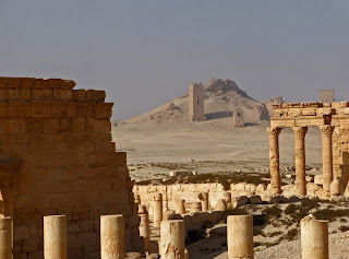

Places with ringing names like Palmyra, a UNESCO World Heritage Site, are now being damaged by the ongoing internal conflicts. In Palmyra, the Syrian Army has set up a base on the hill just behind the Roman ruins and firing on them from the ancient strategic position of the citadel and there is nothing we or the UNESCO can do about it. A group that goes by the name “Syrian Archaeological Ruins in Danger” has set up a Facebook space for people to share the news and make us aware of the destruction that threatens the cultural heritage of Syria, especially since reports of actual gunfire on the ruins came through.

Looting is another problem, although not a new one but with no strict reinforcement whatsoever, it is easy to smuggle artefacts over the border to antiquities markets in Europe and the United States. Recently a memo written by the Syrian Prime Minister Adel Safar addressed to the ministers of Culture and Finance as well as to the Governor of the Central Bank has leaked. Safar claims that “professional international gangs” have brought “equipment and satellite communication devices for stealing manuscripts and robbing museums, safes, and banks” (see Global Heritage Fund). Well, whether international or local communities are at fault or not, repeated looting is unfortunately a fact.

In the same article I read that security in Syria’s 25 antiquities museums is being compromised by the ongoing conflict. Provincial museums are hit the hardest as they are spread all over the country near the pertaining excavation sites. Moving their contents to safer locations seems not to be feasible in the present circumstances. I recall the remote locations along the Euphrates, Rasaffa, Halabia, Deir Ezzor, Dura Europos and most ancient Mari … All so close to the Iraqi border, still looking out over the bare desert from their lonely spot. What a mess!