Alexandria's founded by Alexander

Alexandria's founded by Alexander the Great (by year BC): 334 Alexandria in Troia (Turkey) - 333 Alexandria at Issus/Alexandrette (Iskenderun, Turkey) - 332 Alexandria of Caria/by the Latmos (Alinda, Turkey) - 331 Alexandria Mygdoniae - 331 Alexandria (Egypt) - 330 Alexandria Ariana (Herat, Afghanistan) - 330 Alexandria of the Prophthasia/in Dragiana/Phrada (Farah, Afghanistan) - 330 Alexandria in Arachosia (Kandahar, Afghanistan) - 330 Alexandria in the Caucasus (Begram, Afghanistan) - 329 Alexandria of the Paropanisades (Ghazni, Afghanistan) - 329 Alexandria Eschate or Ultima (Khodjend, Tajikistan) - 329 Alexandria on the Oxus (Termez, Afghanistan) - 328 Alexandria in Margiana (Merv, Turkmenistan) - 326 Alexandria Nicaea (on the Hydaspes, India) - 326 Alexandria Bucephala (on the Hydaspes, India) - 325 Alexandria Sogdia - 325 Alexandria Oreitide - 325 Alexandria in Opiene / Alexandria on the Indus (confluence of Indus & Acesines, India) - 325 Alexandria Rambacia (Bela, Pakistan) - 325 Alexandria Xylinepolis (Patala, India) - 325 Alexandria in Carminia (Gulashkird, Iran) - 324 Alexandria-on-the-Tigris/Antiochia-in-Susiana/Charax (Spasinou Charax on the Tigris, Iraq) - ?Alexandria of Carmahle? (Kahnu)
Showing posts with label Antipatrea. Show all posts

Tuesday, June 23, 2015

Antipatreia, a city referring to Antipater?

Today Berat in Albania is specially known for its Ottoman houses, which amazingly have survived the severe communist regime of Enver Hoxha. Not my cup of tea, sorry, but my attention rises when I read a street sign Rruga Antipatrea, a street named after Antipater? It feels like meeting family and of course, I have to explore this source.

Well, it seems that Berat is built on top of ancient Antipatreia, originally settled by a Greek tribe here in northern Epirus in the 6th century BC. The name Antipatreia apparently leads us back to Cassander who took control of the region in 314 BC. When the Romans arrived in 200 BC, they are said to have razed the city walls and massacred the entire male population. No wonder I see no trace from antiquity. The Byzantine Emperor Theodosius II in turn strengthened the walls again in the 5th century and about one hundred years later Emperor Justinian entirely rebuilt them. We had to wait till the 13th century for a revival of Berat when a fortress was built, and this is now the heart of old Berat with picturesque streets and medieval houses and churches.

Berat is beautifully set on both banks of the Osum River and under this threatening sky, it seems to revive some spirits from the past. A strange encounter to say the least.

Tuesday, March 17, 2015

Along the Via Egnatia: from Ohrid to Elbasan in Illyria

The Via Egnatia entered Illyria at Ohrid in the east, then ran through Elbasan, from where one arm connected directly to Dyrrhachion (see: Along the Via Egnatia: Dyrrhachion in Illyria). Another one diverged to Apollonia and Antipatrea (Berat) to end also in Dyrrhachion on the Adriatic coast, where ships ferried people and goods to Brundisium (Brindisi) on the Italian side. As mentioned earlier, the Via Egnatia was built by the Romans in the 2nd century AD and served as a major connection between Byzantium and Rome (see: Via Egnatia, a road to remember).  

The first traces of Ohrid go back to the conquest by Philip II of Macedonia, Alexander’s father, when the city was still called Lychnidos. After a first truce with the Illyrian King Bardylis that was sealed in 360 BC by marrying his granddaughter Audata, Philip attacked in force in 357 BC, killing some 7,000 Illyrians. The outcome was that Philip extended the power of Macedonia all the way to Lake Ohrid, a territory that Alexander inherited. After the tumultuous and unstable centuries after Alexander’s death, the Romans arrived in 148 BC. By the end of the 3rd century AD, most classical and Hellenistic temples were torn down by the early Christians, who built their colossal churches right on top. The very name Ohrid, however, appears for the first time in 879 AD.

Today, Ohrid is part of the Republic of Northern Macedonia and a pilgrimage site because of its many early Christian churches. The city counts as many as 365 of them, and the monastery of Saint Naum (established in 905) may well be the oldest.

Well, this takes me too far away from Alexander’s days, of which close to nothing remains. There is, however, the ancient theatre, built in 200 BC, which is the only one from Hellenistic times since all others in the Republic of Northern Macedonia are Roman. The location of this theatre is, as always, sublime, gently nestled between two hills with a breathtaking view over Lake Ohrid. Unfortunately, only the lower section of this theater has been preserved, and we have no estimate of its seating capacity. It was initially used for gladiator fights, but soon served as an execution place for the early Christians. The locals resented these practices, and after the demise of the Roman Empire, they buried the theater under a thick layer of soil. This is actually the part we are seeing today, which was discovered by accident in the 1980s during construction works.

However, I have not seen any traces of the Via Egnatia here at Ohrid. It is almost impossible to enter the city without passing through one of the two gates in the defensive walls from the 10th century, which the Ottomans continued to use, so this may be a place to look for this famous road.

I had more luck at Elbasan, where the route of the Via Egnatia has been clearly picked up and is even signposted as “The Rehabilitation of the Egnatia Road was funded by the European Union”. It runs right through the city center, and I wonder whether someone did search for its original pavement. It now blends in with the neighboring streets, although it has been established to match the Roman Decumanus of Elbasan. Well, it is exciting anyway to find some traces!

Luckily, Elbasan has more to offer. Outside the city walls, one cannot miss the remains of a Byzantine Basilica from the 5th-6th century, where mosaic floors and painted walls were found. Today, it is a park where the locals linger in the shade of the trees and drink from the adjacent well, decorated with slabs recuperated from the basilica. The city walls here are quite impressive and in a good state of conservation. The first to protect the city was obviously the Romans, who, in the 3rd or 4th century, built a substantial fortress with towers. Later, Emperor Justinian improved the fortifications, which were, however, of no use against the repeated attacks of the Huns and other invaders from the north. Reconstruction started under Sultan Mehmet II in 1466, and Elbasan remained a main Ottoman center for the next 450 years or so. This means that these sturdy walls were maintained till the early 20th century, and it shows.

So, in the end, there is still a lot of work to do in order to map this famous Via Egnatia. I hope that in time, more of its itinerary and pavement will surface.

[Click here to see all my pictures of Ohrid]

Thursday, March 5, 2015

Along the Via Egnatia: Dyrrhachion in Illyria

Except for the significant remains in Apollonia, which I discussed earlier (see: Along the Via Egnatia: Apollonia in Illyria), the other cities along the Via Egnatia have little remains to offer, merely indications of where to find its course. As poor as those remains are, I am trying to gather as much information as possible in this corner of Illyria (today’s Albania), stopping this time at Dyrrhachion.

As mentioned before, the Via Egnatia (see: Via Egnatia, a road to remember) was built by the Romans in the 2nd century AD and was the main road between Byzantium and Rome. As far as Illyria, the road came from Ohrid (Republic of Northern Macedonia) in the east and then ran through Elbasan, from where one arm connected directly to Dyrrhachion (Dürres). Another one diverged to Apollonia and Antipatrea (Berat) to end also in Dyrrhachion on the Adriatic coast where ships ferried people and goods to Brundisium (Brindisi) on the Italian side.

This time, I’m stopping at the most western end of the Via Egnatia on the Illyrian side of the Adriatic Sea, i.e., at the city of Dyrrhachion situated at the narrow in the Adriatic Sea right across from Brindisi, some 200 km to the west. The only significant testimony from antiquity that is left for us to see is the Roman amphitheater from the first half of the 2nd century AD, and even this is incomplete since there are still modern houses sitting on top of it. Yet it is rather interesting to wander through the vaulted corridors, discovering even a small Byzantine chapel. The oval amphitheater reached its longest diameter of 120 meters and stood originally 20 meters high. It offered seating for 15,000-18,000 spectators who watched gladiator fights, animal combats, or other artistic shows. It is sad, though, to see that all the seating material has been removed – most probably reused somewhere else. Yet in spite of its bareness and partial excavation, it is a most impressive construction.

As early as 627 BC, the first colonists from Corinth and Corfu founded the city of Epidamnos, named after the Illyrian King Epidamnos, its co-founder. The king’s daughter had a son who received the name Dyrrhachion, and it was this name that stuck. Dyrrhachion was the ideal location for a city, built around a natural harbor with high cliffs and protected on the land side by swamps.

Obviously, the envious Romans had their mind set on this prosperous city and after a fierce fight with the Illyrians in 229 BC, they took possession of the city, which they renamed Dyrrhachium, modern Dürres.

Dyrrhachium was the site of a battle during Caesar’s Civil War on 10 July 48 BC. He faced Pompey, who came out victorious, although not for long. The decisive battle of the Civil War was fought at Pharsalus in Central Greece on 9 August of that same year. This battle eventually led to Pompey's assassination on 3 September 48 BC. Another waste of lives in history …

Emperor Augustus turned the city into a colony for his veterans after the Battle of Actium, proclaiming it to be a free town. By the 4th century, Dyrrhachium became the capital of the Roman Province of Epirus Nova, but it was soon hit by a severe earthquake that destroyed the city’s defense walls. They were almost immediately rebuilt to a height of 12 meters and were wide enough for four horsemen to ride abreast on them. The remaining portions of the wall from the fifth century are still in place but have lost most of their strength and were first reshaped by the Byzantine Emperor Anastasios I after the catastrophic earthquake of 345 AD. He defended the city with three rows of walls guarded by consecutive fortification towers every 60-65 meters. During later occupations, the walls were modified several times. Dyrrhachium did not escape the repeated attacks by the Huns, but in Byzantine times, the city gained importance as a major link with Western Europe once again. 

There are no traces of the Via Egnatia in Dürres, but I am pointed towards a tall apartment building near the beach that supposedly stands on top of it. The nearby lonely Venetian tower from the 15th century is said to be built over an earlier Byzantine construction while reusing its stones. It stands nine meters tall with a diameter of 16 meters and is surrounded by intriguing modern pebble mosaics with birds and fish moving around in a black-and-white pattern.

[Click here to see all my images of Dürres]

Thursday, January 1, 2015

Looking for Illyrian remains in Albania

Albania sounds to be the right place to find traces of Illyria, if any are to be found. 

We know that Alexander spent time in Illyria, but not where. There were no cities of importance, but people scattered around in small tribes, fighting among themselves and invading Macedonia on a regular basis in search of fertile land. The borders of Illyria were not clearly drawn. Those of today's Albania are but don't match either with old Illyria, although roughly in its center, nor with Epirus in the south, where it is shared with Greece.

Honestly, I don't know what proof of Illyria I can find or will come across, for they had no alphabet, cities, or art of their own – at least to my knowledge. Albania is not making things easier either, since the country has been locked away for half a century with a totalitarian regime that can only be compared to North Korea. It is now trying to emerge in the hope of meeting Western standards, although the Albanians have only scant notions of what that means, especially those living in the eastern mountains, where time has come to a standstill. I am on a general tour of one week, which is supposed to touch base with the key periods of Albania's history, the Macedonians and Greeks, the Romans and Byzantines, the Ottomans and Skanderberg (National Albanian Awakening), the Slavs, King Zog with WW1, the many foreign rulers during WW2, and the authoritarian communist regime under Enver Hoxha. An extremely long and varied timeline, although I am interested only in the very first centuries. Whatever I'll learn about the Illyrians themselves and the Macedonian occupation is a welcome bonus.

In a previous blog about the Illyrians (see: A closer look at Illyria), I summarized the roles played by King Philip II of Macedonia and his son, Alexander the Great, in putting Illyria on the map. After becoming king of Macedonia, Philip prioritized signing a treaty with the Illyrians, including his marriage to Audata, King Bardylis' granddaughter. This was only a way to win time because one year later, Philip marched north. He met the Illyrian army near Lake Ohrid, where he was victorious, and demanded that the Illyrians pull out of Upper Macedonia north to Lake Lychnitis. Alexander, in turn, sought refuge in Illyria after the brawl during his father's wedding to Cleopatra, Attalus' niece, in 337 BC. Attalus brought a toast to a lawful successor of Macedonia, implying that Alexander was a bastard. We know how Alexander reacted, especially since his father took Attalus' side. This was when Alexander left for Illyria, taking his mother, Olympias, to the safety of her brother's court in Epirus.

Peace with Illyria lasted while it lasted, for as soon as they heard that King Philip was assassinated in 336 BC, they felt free from any obligation towards Macedonia. Alexander could not afford to have these troublesome tribes raiding his northern borders while preparing to cross to Asia. So, as soon as the most urgent matters were settled in Pella, Alexander took his army north and not only defeated the Illyrians but also mopped up all the resistance. Ultimately, the Illyrians became faithful allies and fought at his side throughout his Asian campaign.

I am curious to see the landscape Alexander crossed to understand where he may have been during his self-imposed exile. I will soon be rewarded when we drive over the most horrible road from Pogradec to Gjirokastra through the mountainous region of southeastern Albania.

Pogradec lies on the crossroad linking Tirana, the Albanian capital, to Elbasan and Korce and on the southern bank of Lake Ohrid, where King Philip made history. This was an essential stop along the Via Egnatia in antiquity that connected Byzantium to Rome. Today, Lake Ohrid is shared between Albania and FYROM (meanwhile renamed the Republic of Northern Macedonia). It is one of the three geological wonders in the world, harboring endemic species that cover the entire food chain. As we drive down to the shores of the lake, the views are superb, and I am impressed by the sheer size of the lake; it must have looked like a sea to people in antiquity. Unlike the more inland parts, our stop in Ohrid has a very Mediterranean feeling. But Alexander has been remembered in these parts, for I find restaurants and wine carrying the name Aleksandrija.
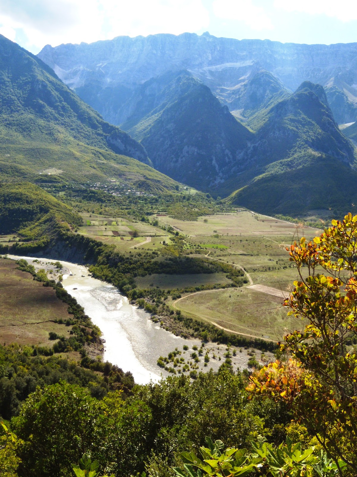
The next day we pick up the main road from Korca south to Gjirokastra, but our maximum speed on this bumpy, degraded, deteriorated, and unmaintained road is 25 km/hour. It takes us all day to get there, but nobody is complaining, for the landscape is absolutely breathtaking! There are no cities or towns, hardly an occasional cluster of houses, recent constructions next to dilapidated shacks that may be stables or housing, who knows. Small gardens, a few fruit trees, a couple of cows, and donkeys are all that people have to live on. I am told that in winter, the snow is two meters deep in these parts, making it impossible for cars or buses to get through. Even today, there is no regular bus service in those parts – how isolated can one live? Was it like this in Alexander's days, I wonder. It cannot have been much better, if any, for the land and weather are still what it was. No wonder the Illyrians were envious of the fertile plains of Lower Macedonia! Overall, the landscape is green with a wide assortment of trees and low bushes between patches of rocky grassland framed with high, barren peaks. Occasionally, a river or stream meanders through the valleys, reflecting the sunlight or threatening clouds. The productive patches of land along those waterways are thriftily cultivated, a pleasant sign in this otherwise austere land.

Then we reach Gjirokastra, whose Greek name is Argyropolis (meaning silver castle), which must have been a fortified place in Epirus (yes, we are in Epirus here!). The oldest finds so far are the city walls from the 3rd century AD. The remains of today's citadel, built between the 6th and 12th centuries, still command the otherwise Ottoman city.
It is funny when I come across a Rruga Antipatrea, which is the old name for Berat, and most probably, this street and city were named after Antipater. A restaurant proudly shows off the name Antigoni. What a shame that there are no written records in Illyria and that the Macedonians or the Greeks didn't bother to write about them.

The most rewarding moments of my tour were those when I faced Illyrian artifacts in the local museums. In Apollonia, I saw my first Illyrian shield from the 4th century BC, which looked so closely like a Macedonian one. I was told that the difference was to be found in its curving; whether that is true or not, I don't know, for it had the same semi-circles and the Medusa head in the center, complete with shiny inlaid eyes that intensified her glance. Another shield was shown at the Skanderberg Museum, with the same semi-circles but carrying the Macedonian star in its center, with an Illyrian helmet and some arrows and spearheads. More helmets were exhibited at the Archaeological Museum of Tirana, where a mold for an Illyrian shield was also displayed.


Yet, the most unexpected highlights are the Royal Tombs of Selca e Poshtme, a place in the middle of nowhere with no decent road leading to it. This is supposedly the ancient city of Pelium, perched high on an acropolis that overlooks the river Shkumbin. In the middle of the 4th century BC, the Illyrian town was protected by a wall, and its life was intensive. They made pottery out of grey clay imitating Greek shapes and decorations, created metal and bronze tools, and traded their goods over the roads along the river, which would later become the Via Egnatia. It was the residence of the Illyrian kings. However, excavations are still in an early stage, and Pelium's role is mainly based on the coins found in cities like Apollonia and Dyrrhachion (modern Dürres). The main discovery is four royal tombs right under the cliff of the Acropolis; definitely Illyrian but, at first glance, very Macedonian. More about these great tombs in my next post, Alexander's psychological warfare in Pelium, Illyria.


Last but not least, I should focus on the route followed by the Via Egnatia, although I have yet to come across any visible pavement like in Philippi, Greece, for instance. From Ohrid, it ran through Elbasan, where it split into two. One arm connected directly to Dyrrhachion (Dürres), and another crossed Apollonia and Antipatrea (Berat) to end at Dyrrhachion on the Adriatic coast. From here, ships ferried people and goods to Brindisi on the Italian side. I regret that I have not seen a remnant of this famous road, but have only been pointed to the line it followed through the cities. Maybe next time?