Alexandria's founded by Alexander

Alexandria's founded by Alexander the Great (by year BC): 334 Alexandria in Troia (Turkey) - 333 Alexandria at Issus/Alexandrette (Iskenderun, Turkey) - 332 Alexandria of Caria/by the Latmos (Alinda, Turkey) - 331 Alexandria Mygdoniae - 331 Alexandria (Egypt) - 330 Alexandria Ariana (Herat, Afghanistan) - 330 Alexandria of the Prophthasia/in Dragiana/Phrada (Farah, Afghanistan) - 330 Alexandria in Arachosia (Kandahar, Afghanistan) - 330 Alexandria in the Caucasus (Begram, Afghanistan) - 329 Alexandria of the Paropanisades (Ghazni, Afghanistan) - 329 Alexandria Eschate or Ultima (Khodjend, Tajikistan) - 329 Alexandria on the Oxus (Termez, Afghanistan) - 328 Alexandria in Margiana (Merv, Turkmenistan) - 326 Alexandria Nicaea (on the Hydaspes, India) - 326 Alexandria Bucephala (on the Hydaspes, India) - 325 Alexandria Sogdia - 325 Alexandria Oreitide - 325 Alexandria in Opiene / Alexandria on the Indus (confluence of Indus & Acesines, India) - 325 Alexandria Rambacia (Bela, Pakistan) - 325 Alexandria Xylinepolis (Patala, India) - 325 Alexandria in Carminia (Gulashkird, Iran) - 324 Alexandria-on-the-Tigris/Antiochia-in-Susiana/Charax (Spasinou Charax on the Tigris, Iraq) - ?Alexandria of Carmahle? (Kahnu)
Showing posts with label Byzantium. Show all posts

Wednesday, May 6, 2026

How the Arabs saved our knowledge from antiquity

In my post, The story around Alexander’s copy of the Iliad, I briefly mentioned how the Abbasid Caliphs in Persia largely contributed to preserving the knowledge of the ancient Greeks. 

A few years ago, my attention was drawn to the glory days of Baghdad around 1000 AD, a city built inside a circle surrounding the central Abbasid Palace, a symbol of power and unity. More amazing than its shape was the fact that its Caliphs invested in hiring scholars to translate ancient Greek documents into Arabic. 

Baghdad was built along the Tigris River in 762 AD, as the residence of Caliph Al-Mansur, the founder of the Abbasid Caliphate. The Abbasid Dynasty was named after the uncle of Prophet Muhammad. A Caliph was the title of the civil and religious leader of a Muslim state, seen as representing Allah on earth. 

Al-Mansur was the first Caliph to honor astrologers. The most famous astrologer was Mash’allah from Basra, who served the Caliphs from 762 to 809 AD. Al-Mansur was convinced that it was written in the stars that the Abbasids were the legitimate successors of the Persian Sassanid Empire. They had been in power from 224 until 651 AD, when they were conquered by the Muslims. Since astrology did not exist in Arabic, Al-Mansur needed to revert to Persian and Greek astrological texts. As a result, he needed these ancient texts to be translated into Arabic.

By 786 AD, Caliph Harun al-Rashid established the House of Wisdom in Baghdad, which originally may have been a Library, where scholars from across the Muslim world would organize their translations. The idea caught on, and other centers flourished a few centuries later in Cordoba and Granada in Spain, as well as in Cairo, Egypt. 

In the western Roman world, we saw our ancient knowledge and know-how disappear into the dark Middle Ages soon after the Fall of Rome in 476 AD. In the Eastern Roman or Byzantine Empire, however, the science of Antiquity survived despite the rise of Christianity. Constantine the Great had made it the official religion, renaming its capital Byzantium after himself, Constantinople.

When Islam entered the stage in the 7th century AD, the Abbasid Caliphate, established in Damascus, was a serious competitor to Constantinople. In about 750 AD, the Caliphate was transferred from Damascus to Baghdad, meaning that the center of power moved east from a Greek-speaking region to a non-Greek-speaking area. Followed a series of wars between the Caliphate and the Byzantine Empire that lasted until the 11th century. 

All that time, the knowledge from Antiquity flowed into Baghdad, where a vast translation project was set up, and top translators were highly rewarded in gold. They concentrated on matters like astronomy, geometry, arithmetic, and even music theory. Aristotle was still held in high esteem, his works as well as his comments. Later translations included Claudius Ptolemy's Almagest, a mathematical and astronomical treatise on the motions of the stars and planets; Euclid's book on geometry; the medical works of Hippocrates and Galen; and Plato’s Republic and Laws. Many other ancient books were translated from Greek, Pahlavi, Neo-Persian, and Syriac into Arabic. 

Simultaneously with this translation movement, Islamic science developed, involving philosophers and scientists alike. A name that stands out is that of Ibn Sina, better known as Avicenna (980-1037), the Father of Early Medicine, whose work was standard in Europe for centuries. Another figure was Al-Khwarizmi (780-860), the Father of Algebra, who introduced the algorithms.

By the mid-11th century, the ideas of antiquity reached Europe in Arabic, traveling to Sicily and Muslim Spain. Over time, they had been enriched with the knowledge that the Caliphs in the Middle East had acquired and developed. We owe it to the Abbasids that the knowledge from classical antiquity reached Europe, where it was generally translated into Latin. 

The Abbasid Caliphate ended in 1258 when Baghdad was sacked by the Mongols. The city was looted and thoroughly destroyed. The invaders burned piles of books, including those that were held in the House of Wisdom. 

Without Baghdad and its western expansion, we would have remained stuck in the dark Middle Ages, and there would not have been a Renaissance. 

Tuesday, January 6, 2026

Roman glassware, as good as new

I have always been fascinated by Roman glassware in all its shapes, forms, and colors (see: The beauty of ancient glassware). 

Yet, I never came across glassware that survived in such pristine condition as that retrieved from the Cape Corse shipwreck in 2023. It lies on a Roman commercial route connecting Luna (modern Luni, Italy) to Massalia (modern Marseille), between Cape Corse in Corsica and the island of Capraia in Italy. It is the second known find with a cargo of almost exclusively glass, either in its raw state as blocks of various sizes or in the finished product of blown glass tableware. 

[Picture from Soprintendenza Nazionale per il Patrimonio Culturale Subacqueo]

The ship sank around 100 AD, and although it was discovered in 2013, we had to wait ten years for an international team of researchers to explore the wreck with two underwater drones. This modern equipment allowed them to retrieve the major part of its precious cargo using a very delicate claw system. 

A few thousand glass artifacts have been recovered, including drinking glasses, bottles, plates, cups, small bowls, and an ointment jar; also two bronze basins and several amphorae of different type such as oriental, the Beirut type, and four Gallic vessels. Combined with the raw glass, this find led the archaeologists to believe that the ship must have originated from a port in the Middle East, possibly Lebanon or Syria, and was headed towards the coast of Provence in Southern France. 

The Syrians were probably the first to have mastered the art of glass blowing as early as the 1st century BC. Craftsmen from Sidon, Aleppo, Hama, and Palmyra developed the technique of using a blowpipe to shape molten glass, which allowed them to create objects faster than from cast glass. As a result, Syria became one of the most important glass production centers in the world, before, during, and after the Roman Empire. 

The main trade route started in Antioch (modern Antakya in Turkey) to supply the markets of Alexandria, Byzantium, and Rome, which, in turn, had steady connections with Massalia.

The question remains, how these thousands of glass objects were still undamaged and survived in such good conditions after resting at the bottom of the Mediterranean for two thousand years.

Sunday, February 9, 2025

The importance of Perinthus

In antiquity, Perinthus was of strategic importance as it controlled Athens grain route from the Black Sea through the Bosporus. Each spring Athenian ships loaded with wheat from the Danube and Maritza basins sailed down via Byzantium, the Hellespont, and further across the Aegean to Athens. 

Perinthus, near the modern city of Tekirdağ, had two harbors in the East and the West side of the peninsula both used for commercial and military purposes. So far, the remains of a shipwreck have been located at a depth of 60 meters, and the finding is under investigation. More of the city’s buildings are being exposed, including an Acropolis with large temples and a theater. Besides the many small artifacts such as bits of jewelry and statuettes, there also is a necropolis.

[Picture from Sozcu.com.tr]

In late 352 BC, King Philip of Macedonia was asked to assist a coalition of Central Thracia, consisting of Byzantium, and Perinthus in besieging the nearby fortress town of Heraion Teichos that threatened Perinthus (see: Philip is bouncing back). He marched his army east, took the town, and returned it to Perinthus, presumably its original owner. 

Philip’s presence in the area was a threat to the Athenians but also to the Persians aiming to control Perinthus. In 340 BC, the Persians ordered Pixodarus of Caria, their ally in Halicarnassus, to help Perinthus revolt against Philip. The operation was not successful. 

Pixodarus then changed his mind as Persia was in turmoil after the murder of King Artaxerxes III. He thought it wise to seek Philip’s support instead. He offered his daughter, Ada, in marriage to Philip’s retarded son Arrhidaeus. The pact was accepted. 

However, Alexander felt left out and decided to act on his own, offering himself as a marital candidate. When Philip got vent of this maneuver behind his back, the agreement with Pixodarus was called off. Philip seriously reprimanded his son by exiling several of his closest friends from Pella (see: Pella, the birthplace of Alexander). 

By 188 BC, Perinthus fell under the rule of Pergamon until the Romans took over in 129 BC. By the end of the 2nd century AD, they used the port as a main hub to ship their troops between the Euphrates and the Danube fronts. On the other hand, Perinthus had an important connection with the Via Militaris that ran west to Philippopolis, Serdica, and Viminacium. From here, the Via Egnatia led to Thessaloniki, Dyrrhachion, and Brundisium. 

Based on inscriptions from the late 2nd century AD, it has been established that the provincial governors of Thracia had a residence in Perinthus. 

[Map from Stilus.nl]

In 286 AD, Emperor Diocletian renamed the city Heracleia to become a state capital. He may well have built a palace here as the outline of the ruins indicates a similarity with his palace in Nicomedia.

Under Constantine in 330 AD, Heracleia was supplanted by Byzantium which was renamed Constantinople. 

In the end, Perinthus lived a long and prosperous history thanks to its strategic location with ideal access to the Black Sea, the Aegean, and the Mediterranean, as well as inland Anatolia, and Egypt. Inevitably, it became a multicultural center populated by different peoples all speaking their own language. That sounds very close to today’s praise of Istanbul joining Europe and Asia. 

Wednesday, February 14, 2024

The Periplus of the Euxine Sea by Arrian – Part 3

In this last part of the PeriplusArrian takes us from Dioscuras/Sebastopolis to Byzantium. 

He starts his story where he left off at the conclusion of part 1, i.e., in Sebastopolis (see: Tour of Colchis: From Trapezus to Sebastopolis). This section, the Cimmerian Bosporus, was not controlled directly by Rome but by a so-called client king. In Hadrian’s day, that was Cotys II, in full Tiberius Julius Cotys, who ruled from 123/4 AD until he died in 131/2 AD. His appointment was made for life, and his successor needed to be officially recognized by Rome. 

At the news of his death, Arrian decided that Hadrian would be interested in having the latest information about the Bosporan Kingdom since it supplied a great deal of wheat, clothing, wine, and slaves. His territory was also an important buffer zone with the warlike Alans living to the north. 

Arrian sailed along the mountainous coastline below the Caucasus to Pityus, some 65 kilometers away. These lands were occupied by the Zilchi, ruled by a certain Stachemphax, also recognized as a king by Hadrian. Follows a list of cities, harbors, and rivers, including the distances between them, from Crimea to the mouth of the Danube River. More familiar are the Greek cities on the south coast of Crimea, such as Panticapaeum (Kerch), Theodosia, Cercinitis, and Chersonesus (Kherson). Panticapaeum, which lies only 11 kilometers from the Tanais River (modern Don River) and flows into Maeotis Lake (Sea of Azov) was seen as the place where Europe ended and Asia started. 

Sailing further west, Arrian stops at the Greek city of Olbia at the mouth of today’s Dnieper River. Next, he heads for the harbor of Odessos, a trading post founded by the Greeks from Istria. From here, he continues to the wide delta of the Ister River (Danube), where he reaches the Island of Achilles or Leuke (possibly Snake Island in Ukraine). Legend has it that Thetis gave it to her son. The island was known for its Temple of Achilles, which held a wooden statue of the hero, as well as Greek and Latin inscriptions in honor of Achilles and his dear PatroclusArrian speaks of many offerings that were made, including sacrifices of animals. Those who sail by the island may “see” Achilles in their dreams or hallucinations. 

Proceeding further down the coast of the Black SeaArrian arrives at Tomis, a colony founded by the Greeks, where Emperor Augustus banished the poet Ovid. The next port was Callatis, established by the Carians, followed by Odessos (another harbor by that name), where he entered Thracia. 

Passing the eastern end of the Haemus Mountains (in central Bulgaria), Arrian reaches Miletus colony of Apollonia, which once held a colossal statue of the god Apollo. From here, he sailed to the not-so-good harbor of Salmydessus (roughly 150 km east of Hadrianopolis, modern Edirne), where Xenophon helped Seuthes II to become King of Thracia. 

By now, Arrian has landed on the Thracian side of the Bosporus. This area is reputed for the Cyanean Islands or Symplegades (also Clashing Rocks), a pair of rocks that clash together when a ship sails through. In Greek mythology, the rocks were defeated by Jason on his way to Colchis on board his ship, the Argo. 

Byzantium is Arrian’s final destination. He concludes by mentioning the local Temple of Zeus Ourios (who grants favorable winds), where Jason and the Argonauts erected an altar to the Twelve Olympian Gods on their return from Colchis. 

In our modern days of traveling by plane and high-speed trains, it is hard to imagine the pace in antiquity when people and armies moved on foot. Ships and barges were a comfortable alternative, although winds and currents were not always reliable. Travelers could never predict the duration of a trip or the time of arrival, but in those days, time was not so much of the essence as it is today. 

Though Arrian wrote his Periplus 130-131 AD, we don’t know how many months or weeks he actually spent at sea. Considering that the circumference of the Black Sea is over 4,000 kilometers, it may be safe to speculate that he spent most of those two years “on the road”. Quite an achievement!

[For the locations, please consult this map]

Tuesday, January 23, 2024

The Periplus of the Euxine Sea by Arrian – Part 2

The second part of the Periplus covers the section From the Thracian Bosporus to Trapezus. 

As mentioned earlier in About Arrian’s Periplus of the Euxine Sea, it could not be established whether this chapter reflects Arrian's personal experience or not. One theory is that he wrote it upon arrival in Trapezus after Hadrian appointed him governor of Cappadocia in 131 AD. 

We should also keep in mind that Arrian was a native of Bithynia, which bordered the south shores of the Black Sea over approximately one-third of its total length. Consequently, he knew the people and the geography of that area very well. As an admirer of Xenophon, he was familiar with the route followed by the Ten Thousand as they marched from Trapezus to Byzantium following the seashore.

[Bust of Xenophon, Carole Raddato (CC BY-NC-SA)]

Whatever the case, this section of the Periplus includes an impressive list of the harbors and rivers on the southern shore of the Black Sea among which are the cities of Herakleia-Pontus founded by the Megarians and the Boeotians at the mouth of the Lycus River; Tios, at the mouth of the Billaeus River and a colony of MiletusAmastris (modern Amasra) that had a harbor 17 kilometers from the River Parthenius; Sinope, another colony of Miletus and home of Diogenes; Amisus, an Athenian colony between the Halys and the Iris River deltas; and, finally, Cotyora, a colony of Sinope. 

Ever since the days of the Hittite Empire, which reached its height in the 14th century BC, the Halys River was the border between several kingdoms; first between Lydia and the Persian Empire, then between the Pontic Kingdom and the Kingdom of Cappadocia. By the 6th century BC, it separated Lydia from Media until King Croesus crossed the river to attack Cyrus the Great and was defeated. 

[From the Greek Reporter]

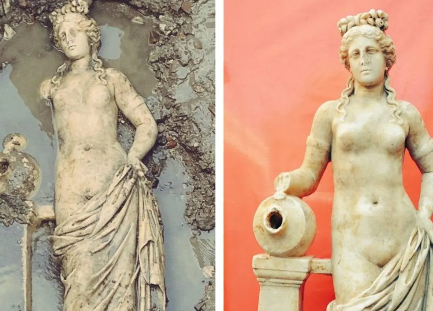
It is worth mentioning that a 1.50-meter-tall statue of Aphrodite has been discovered recently in ancient Amastris. It could be established that it is a Roman copy from between 180 and 200 AD that was inspired by Praxiteles school in the 4th century BC. The ancient city was named after Amastris, the niece of King Darius III, who married Dionysos, the tyrant of Herakleia-Pontus.

The map included in my post About Arrian’s Periplus of the Euxine Sea is most useful for locating all the cities, harbors, and rivers mentioned above. 

It should be said that while inspecting the Cappadocian frontier harbors in 123 AD, Emperor Hadrian had already visited part of the southern Euxine Sea, including Trapezus. With this in mind, Arrian now informed the emperor that Trapezus was building a new harbor, replacing the mooring where ships could only anchor in summer. 

It is quite amazing to see so much geography and history being exchanged. We tend to forget the many lines of communication that existed in antiquity, with traders, merchants, scholars, philosophers, astronomers, kings, and emperors traveling far and wide, by land and by sea.

[to be continued in Part 3]

Wednesday, January 3, 2024

About Arrian’s Periplus of the Euxine Sea

Beyond doubt, Arrian is best known for his Campaigns of Alexander the Great but as I mentioned in my earlier post, What do we know about Arrian of Nicomedia, he was a prolific writer. However, most of his works have now been lost. 

Such was the case for his Periplus of the Euxine Sea, the Circumnavigation of the Black Sea, an official military report Arrian wrote in Latin to Emperor Hadrian, who had inspected the area before him. Additionally, he composed a series of informal letters to Hadrian using Greek.

Although Arrian was a member of the Roman imperial administration, he also belonged to the Greek literary elite. As a native of still very Greek Bithynia in Asia Minor, Arrian grew up with this dual identity making him a true Graeco-Roman. Addressing his Greek account to the Philhellenic emperor underscores his friendly and personal relationship with Hadrian.

Arrian was very much inspired by Xenophon, a philosopher, and historian from the 4th century BC – hence his nickname of “Second Xenophon.” In fact, Arrian picked up Xenophon’s tracks on the Black Sea at Trapezus as he led his Ten Thousand according to his Anabasis.

Arrian’s Greek version of the Periplus with its valuable information about the Black Sea region luckily survived. It dates from 131 AD, one year after he had been appointed governor of Cappadocia.

In his days, Cappadocia was a Roman frontier with forts along the coast of the Black Sea. Arrian’s duty was to protect that line of defense and the routes into the hinterland up to the Parthian Empire further east. He was also responsible for the Pontic Fleet based in Trapezus (modern Trabzon) and for protecting the grain supply from Crimea. Besides those matters about his military and diplomatic mission, Arrian outlined the navigation routes and ports of the Black Sea and concentrated on economic activities and resources.

His Periplus covers a counter-clockwise voyage around the Black Sea, made in three separate trips. During his first journey, he sailed from Trapezus to Sebastopolis. His letters to Hadrian are bundled in chapters 1 to 11 and constitute the longest and most interesting part of his Greek Periplus.

His second expedition contained in chapters 12 to 17 took him from the Bosporus to Trapezus, and the third one is covered in chapters 18 to 25 traveling from Sebastopolis to Byzantium. These two voyages may well have been undertaken by different people as the narration is less personal and less fluent.

Much of the writing focuses on the rivers, landmarks, harbors, and cities, including the distances and other relevant information for sailors and travelers alike. It also includes information regarding the local population and the safe havens. True to himself, Arrian likes to insert local stories from Greek mythology such as Jason and the Argonauts and Prometheus, and often quotes Homer.

In short, a complete traveler’s guide that may still be helpful today!

[Continue reading in Part 1]

Tuesday, October 29, 2019

Dancing with the Lion: Rise by Dr. Jeanne Reames


Dancing with the Lion: Rise by Dr. Jeanne Reames (ISBN: 978-1-62649-900-3) is Book Two of Dancing with the Lion: Becoming by the same author - the historical fiction book about the youth of Alexander the Great described earlier (click here to read my post on Book One).

This second part answers many questions that I was left with after reading the first part. It seems that this book was split in two for publishing reasons but this certainly does no justice to the story. Whatever the reason for this separation, I don’t think that in this case, the end justifies the means.

This being said, I now understand the title (which I questioned after reading Book One) and it turns out that Philip is the Lion and Alexander his cub. Why revealing this so late in the story, especially since it was cut in two parts, is not the best idea. It feels familiar, however, to renew with the main characters of Alexander, Hephaistion, and Philip which are – as I pointed out in Book One - as close to reality as can be expected.

It was nice to pick up the story again and submerge into the action. We accompany Alexander as his father’s Page during his Thracian campaign. Elected to be his father’s Regent as Philip is besieging Byzantium, we witness the prince’s first command to successfully crush the revolt on the northern border of Macedonia. At Chaironeia, Alexander annihilates the Theban Band. The events leading up to the murder of King Philip and Alexander’s proclamation as his successor are the true climax.

Throughout the book, Alexander is very much aware that his life at court with all its intrigues and complications stands in sharp contrast with the warmth and charismatic life he discovers at Hephaistions home. It makes him realize that he has to pay a high price to live as a Royal Prince and heir to the throne of Macedonia.

In between, several chapters are treating the deep affection and love that blossom between the young prince and Hephaistion, both mentally and physically. I am not sure we need all the tiny spicy details for this phase of Alexander’s coming-of-age but there seems to be a tendency to present this book as an LGBTQ Romance rather than a Historical Romance. Well, maybe all readers will find something to their liking but as an Alexander novel the sexual approach is not a priority. After all, the Greeks in antiquity were bisexual and that should suffice.

Thursday, April 11, 2019

Crossing the Danube River

The mighty Danube River forms the modern border between Bulgaria and Romania, except in its lower course, where it falls entirely within Romania before emptying into the Black Sea. This is where Alexander defied the Thracians and the Triballians on their island retreat of Peuce.

He had ordered his fleet stationed at Byzantium to sail up the west coast of the Black Sea to meet him in the estuary of the Ister River (Danube). However, his ships were of no use because they were too few in number and not sufficiently manned to dislodge the enemy’s forces; besides, in most places, the river banks were too steep for a landing.

Alexander had to come up with another plan, and instead of wasting time trying to dislodge the Thracians and Triballi refugees on Peuce Island, he opted to isolate them by attacking the Getae on the opposite riverbank. Inspired by Xenophon, Alexander instructed his troops to collect the boats and dug-outs moored along the river and to stuff the army tents with hay to use them as floating devices.

Overnight, the king managed to ferry 4,000 infantrymen and 1,500 cavalry (imagine the strain on the horses!) across the estuary of the Danube. No wonder the Getae were in shock as soon as they saw the Macedonians, and they fled at the first cavalry attack. The same day, Alexander ferried the entire army back to base camp, where he received the surrender of the Triballians and Thracians pinned on Peuce Island, as well as from other tribes along the Danube.

It sounds like such a simple statement, but the logistics involved are not to be underestimated, considering the current and the width of the river. The delta is known to be strewn with many islands and sandbanks, turning any crossing into a daring challenge. Over the centuries, the bedding and the mouth of the Danube have changed dramatically, making it very hard to pinpoint the exact place where this operation took place.

In the end, the Thracians became an elite corps in Alexander’s army, successfully carrying out the roughest and most dangerous jobs. They were often praised by the king in person for their daring and often reckless attacks.  

Tuesday, August 14, 2018

Istanbul, The Imperial City by John Freely

Istanbul, The Imperial City by John Freely (ISBN 978-0140244618) is by far the most complete historical guide you can find. It is a lightweight, handy format that easily fits into your backpack.

Every first-time visitor will inevitably be overwhelmed by the many remnants of this capital, famed successively as Byzantium, Constantinople, and Istanbul, which has had a far-reaching role on the world map for over three thousand years.

For obvious reasons, the book is divided into three parts.

The first and shortest covers the city's birth on the Bosporus and the first Greek colonization to become the Roman Byzantium, with all the wealth that could be displayed. This was the city besieged by Philip II of Macedonia in preparation for his invasion of Asia. The Romans, in turn, linked the city to Italy through the Via Egnatia, and the Golden Milestone known as The Million marked the distance to the towns stringed along the road. The Great Palace and the Hippodrome date from that era.

The second part starts with the advent of Emperor Constantine in 330 AD, who renamed the city after himself, Constantinople. As such, it became the seat of the Eastern Roman Empire. Under great emperors like Theodosius, Justinian, and the dynasty of the Comneni, the city expanded again. Constantinople was besieged repeatedly from the 7th to the 10th century by the Sassanids from Persia, the Arabs from the Umayyad caliphate, and the Crusaders, who thoroughly sacked the city.

The last and no less important part treats the birth of Istanbul as the capital of the rising Ottoman Empire that started in 1453. Sultans like Suleiman the Magnificent wrote history, and many of today's great buildings were built in those days. To name just a few, there is the Grand Bazaar, Topkapi Palace, and the many mosques, especially those made by Sinan, to rival the Hagia Sofia from the 6th century.

Instead of a dry and dull account, John Freely takes us by the hand and leads us from one place to the next, often unfolding the many superposed layers of Istanbul's rich history. A handy additional chapter is dedicated to Notes on Monuments and Museums, which the author referred to in previous pages. As another helpful tool in the complicated and long succession of rulers, there is also a complete list of all the Byzantine emperors and Ottoman sultans ending when Turkey as such was born and Atatürk became its leader.

As always, John Freely makes history look simple, and it is a great pleasure to travel through the ancient world in his footsteps. Another excellent book by the same author is Aladdin's Lamp: How Greek Science Came to Europe Through the Islamic World – a treasure trove of knowledge!

Saturday, April 11, 2015

The surprise of Butrint, ancient Buthrotum in Epirus

Under Roman rule, the Via Egnatia strategically connected Byzantium via Thessaloniki to Rome thanks to the crossing of the Adriatic Sea between Dyrrhachium and Brundisium. But there was another lesser road that led south to the city of Buthrotum, modern Butrint, right across from Saranda, one of the newest bay resorts in Albania.


Yet Buthrotum was not born with the Romans but like most towns in the area, it was founded by colonists from Corinth and Corfu at some time during the 7th or 6th century BC – although according to the legend its founder was a son of King Priam of Troy, which is a more noble ancestry, of course. To me, this is Epirus, the homeland of Queen Olympias, Alexander’s mother and it is not surprising that in her days the city was important enough to have a sanctuary dedicated to Asclepius with its own theatre and agora; besides, it was protected by a city-wall with five entrance gates.

For some reason, I always thought that all of Epirus was part of modern Greece, but it seems that this ancient country has been split up between Greece to the south and Albania to the north. All I knew about it was the oracle of Dodona, so it is a surprise to hear that Buthrotum was important before the arrival of the Romans. The main attraction may well have been the sanctuary of Asclepius, which was built on a series of terraces rising from a paved area in front of the theatre. The reconstruction as shown on the billboard at the entrance of the site is very clear, but it is much harder to find pre-Roman evidence on the site itself. The sanctuary included a temple, a stoa, and a treasury, all modified by the 3rd century BC to include a theatre and a building that may have served as a hotel for the pilgrims.

As early as 228 BC, Buthrotum became a Roman protectorate, and its influence spread steadily till the city was included in the province of Macedonia. Julius Caesar thought it was an appropriate place to settle his veterans after fighting Pompey in 44 BC, but a wealthy local landlord, Titus Pomponius Atticus, objected to these plans and went so far as to plead his case at the Roman Senate through his friend, the orator Cicero. He was successful, and only a small number of settlers were relocated to Buthrotum. They blended in pretty easily with the locals, and their presence left a definite Roman stamp on the city.


It seems appropriate to take a closer look at Titus Pomponius Atticus, one of the richest men of his time. He lived in Athens for almost twenty years (hence the name Atticus) and showed great interest in Greek culture and philosophy. He bought an estate near Buthrotum and probably acquired more land in neighboring Epirus and Corfu. Although his villa is explicitly mentioned in his correspondence with Cicero, it has not yet been found, but it is generally accepted so far that it was situated in the river valley, where cool breezes soften the heat of summer. Atticus’ wealth, which he acquired as a financier and by managing his land properties, gave him great influence in politics as we have seen above. He was a gifted politician who managed to remain on good terms with both parties involved, the Romans and the locals. He died in 32 BC, aged 78, shortly before the Battle of Actium. Five years earlier, he gave his daughter Caecilia in marriage to Agrippa, Augustus friend and general. Consequently, Atticus’ influence continued after his death through his son-in-law.

In 31 BC, Emperor Augustus conceived plans similar to those of Caesar for after his victory over Marc Anthony and Cleopatra at Actium (some 200 km south of Butrint), he considered Buthrotum to settle his veterans. Once again, the new arrivals, though limited in number, blended in well, and the city expanded rapidly, doubling in size even. At this stage, Buthrotum required a major building plan, which was funded by Augustus in person as well as by his family or private parties. The main projects were the construction of a new aqueduct to feed the many fountains and bathhouses, and a bridge across the Vivari Channel. At this stage, the city appears as Colonia Augusta Buthrotum. Most of what we see today at Butrint may date from Augustus reign since statues of the emperor and of his wife Livia have been found – a sure sign of the city’s loyalty and support.

As in any excavation site, the theatre is what we see first. Although the earliest construction goes back to the 4th century BC, when it was part of the Sanctuary of Asclepius, it was clearly rebuilt and enlarged during the 2nd century AD to become the Roman centerpiece of the city. Today, the lower part of the theater, mainly the stage, is flooded by groundwater, adding a romantic touch with its reflection in the pool. Unique are the many manumission inscriptions that have survived on the outside walls of the theater, dating from shortly after 232 BC. The freeing of slaves, which seems to have lasted for sixty years, was accomplished in the name of a god, generally Asclepius, hence the close link between the theater and its inscribed walls with the treasury of which close to nothing remains.

Behind the cavea of the theater are the remains of the Roman Baths, which are also flooded. Part of the hypocaust is being preserved, exposing some of the fire-resistant bricks used in the floor heating – always an exciting element, I’d say.

The Forum is located next to the theater and the Baths, and originally was located at the heart of the Hellenistic city. In those early days, i.e., late 2nd/1st century BC, it measured a modest 4.5 x 25 meters. Towards the 2nd century AD, the area was enlarged to the size we see today, 52 x 20 meters, but most of it still remains buried.

Further down the island, around the corner of the abovementioned buildings, are the remains of a rather imposing Nymphaeum that must have lined up with the Roman aqueduct that ran across the Vivari Channel and the valley floor to the hills from where the water was transported. Thanks to one of the billboards, I am able to locate the header tank of this aqueduct on the other side of this channel. The spring itself has not been located with certainty, but it seems to be found near Çuka e Aitoit (Eagle Mountain), a rough 12 km away. This fountain, once enhanced with statues of Dionysus and Apollo, appears to lean against the city wall, basically built in the 6th century AD but mixed with remains of earlier Roman constructions. The access to the Vivari Channel, however, was preserved as there are several entrance gates in this wall, still easily recognizable. Today, it is a very peaceful water channel where time seems to have come to a standstill. It is not certain, but this aqueduct may well have served as the first bridge across the channel, and as such, adding to Buthrotum’s status since the city was now connected with the wider Roman world. Aqueducts were very costly enterprises, and only rich cities or those sponsored by private patronage could afford them. Great cities like Athens or Corinth, for instance, didn’t have any aqueducts till the rule of Emperor Hadrian! That definitely proves how wealthy and how important Buthrotum was in its heyday!

This is also the area once occupied by the Gymnasium, but which in Byzantine times was filled by the Great Basilica and its dependencies. It is here that we find a Baptistery from the 6th century AD with an exquisite mosaic floor, covered for its own protection, which is unfortunate for us visitors. It consists of seven circular bands around the baptismal font, thus creating the figure eight, the Christian number for salvation and eternity, I am told (although I have not encountered this explanation before). The mosaics show animals (representing land), birds (representing air), and fish (representing water), in accordance once again with early Christian symbols of salvation. The entrance is flanked by two mosaics of large peacocks (symbolizing paradise and immortality) with a vine growing out of a vase (symbol for the blood of Christ).  Apparently, the roof of this Baptistery was supported by two circular rows of columns, of which only the bases remain. It is worthwhile to mention that this is the second-largest Baptistery in the Eastern Roman Empire after the Aya Sophia in Istanbul.


From the 3rd century onward, Buthrotum started to decline, and a severe earthquake destroyed large parts of the city. It shrank, and a new, smaller city wall was needed. The relief of the so-called Lion Gate on the road to Epirus, which was added in the 5th century to reduce the size of the gate, is a clear illustration. Even an untrained eye can see how this wall has been altered time and again, with steps leading nowhere and dead-end tunnels. When Buthrotum became the seat of a bishop in the 6th century, the Baptistery and Basilicas mentioned above were built, and at the same time, the city walls were reinforced.

But like its neighbors, it was attacked and sacked by the Huns. Over the following centuries, Butrint was occupied in turn by several foreign forces till it turned into a malaria-infested swamp.

The very top of today’s Butrint is crowned by a castle that was reconstructed over the ancient acropolis and now serves as a museum that badly needs some improvement or modernization, unfortunately. It houses finds from Butrint itself but also from other nearby sites, showing some pieces from the Hellenistic occupation but mostly from the prosperous Roman period.

Today, a flat barge ferries men and cars across the Channel to the Vrina plain on the other side. In Roman times, that was the location of a thriving suburb of Buthrotum where the rich and famous had their vast residences. It is here that archaeologists are looking for the remains of Titus Pomponius Atticus’ estate. Work in progress …