Alexandria's founded by Alexander

Alexandria's founded by Alexander the Great (by year BC): 334 Alexandria in Troia (Turkey) - 333 Alexandria at Issus/Alexandrette (Iskenderun, Turkey) - 332 Alexandria of Caria/by the Latmos (Alinda, Turkey) - 331 Alexandria Mygdoniae - 331 Alexandria (Egypt) - 330 Alexandria Ariana (Herat, Afghanistan) - 330 Alexandria of the Prophthasia/in Dragiana/Phrada (Farah, Afghanistan) - 330 Alexandria in Arachosia (Kandahar, Afghanistan) - 330 Alexandria in the Caucasus (Begram, Afghanistan) - 329 Alexandria of the Paropanisades (Ghazni, Afghanistan) - 329 Alexandria Eschate or Ultima (Khodjend, Tajikistan) - 329 Alexandria on the Oxus (Termez, Afghanistan) - 328 Alexandria in Margiana (Merv, Turkmenistan) - 326 Alexandria Nicaea (on the Hydaspes, India) - 326 Alexandria Bucephala (on the Hydaspes, India) - 325 Alexandria Sogdia - 325 Alexandria Oreitide - 325 Alexandria in Opiene / Alexandria on the Indus (confluence of Indus & Acesines, India) - 325 Alexandria Rambacia (Bela, Pakistan) - 325 Alexandria Xylinepolis (Patala, India) - 325 Alexandria in Carminia (Gulashkird, Iran) - 324 Alexandria-on-the-Tigris/Antiochia-in-Susiana/Charax (Spasinou Charax on the Tigris, Iraq) - ?Alexandria of Carmahle? (Kahnu)
Showing posts with label Dyrrhachion. Show all posts

Sunday, February 9, 2025

The importance of Perinthus

In antiquity, Perinthus was of strategic importance as it controlled Athens grain route from the Black Sea through the Bosporus. Each spring Athenian ships loaded with wheat from the Danube and Maritza basins sailed down via Byzantium, the Hellespont, and further across the Aegean to Athens. 

Perinthus, near the modern city of Tekirdağ, had two harbors in the East and the West side of the peninsula both used for commercial and military purposes. So far, the remains of a shipwreck have been located at a depth of 60 meters, and the finding is under investigation. More of the city’s buildings are being exposed, including an Acropolis with large temples and a theater. Besides the many small artifacts such as bits of jewelry and statuettes, there also is a necropolis.

[Picture from Sozcu.com.tr]

In late 352 BC, King Philip of Macedonia was asked to assist a coalition of Central Thracia, consisting of Byzantium, and Perinthus in besieging the nearby fortress town of Heraion Teichos that threatened Perinthus (see: Philip is bouncing back). He marched his army east, took the town, and returned it to Perinthus, presumably its original owner. 

Philip’s presence in the area was a threat to the Athenians but also to the Persians aiming to control Perinthus. In 340 BC, the Persians ordered Pixodarus of Caria, their ally in Halicarnassus, to help Perinthus revolt against Philip. The operation was not successful. 

Pixodarus then changed his mind as Persia was in turmoil after the murder of King Artaxerxes III. He thought it wise to seek Philip’s support instead. He offered his daughter, Ada, in marriage to Philip’s retarded son Arrhidaeus. The pact was accepted. 

However, Alexander felt left out and decided to act on his own, offering himself as a marital candidate. When Philip got vent of this maneuver behind his back, the agreement with Pixodarus was called off. Philip seriously reprimanded his son by exiling several of his closest friends from Pella (see: Pella, the birthplace of Alexander). 

By 188 BC, Perinthus fell under the rule of Pergamon until the Romans took over in 129 BC. By the end of the 2nd century AD, they used the port as a main hub to ship their troops between the Euphrates and the Danube fronts. On the other hand, Perinthus had an important connection with the Via Militaris that ran west to Philippopolis, Serdica, and Viminacium. From here, the Via Egnatia led to Thessaloniki, Dyrrhachion, and Brundisium. 

Based on inscriptions from the late 2nd century AD, it has been established that the provincial governors of Thracia had a residence in Perinthus. 

[Map from Stilus.nl]

In 286 AD, Emperor Diocletian renamed the city Heracleia to become a state capital. He may well have built a palace here as the outline of the ruins indicates a similarity with his palace in Nicomedia.

Under Constantine in 330 AD, Heracleia was supplanted by Byzantium which was renamed Constantinople. 

In the end, Perinthus lived a long and prosperous history thanks to its strategic location with ideal access to the Black Sea, the Aegean, and the Mediterranean, as well as inland Anatolia, and Egypt. Inevitably, it became a multicultural center populated by different peoples all speaking their own language. That sounds very close to today’s praise of Istanbul joining Europe and Asia. 

Friday, May 15, 2015

Revealing Byllis in ancient Illyria

Before my trip to Albania in search of Illyrian remains (see: A closer look at Illyria), I had never heard of Byllis, for even on the internet, the information is pretty scant and vague. Yet the site of Byllis is one of those where you feel at home and where every ruin is exactly as it should be – a very strange awareness!

The location of Byllis has nothing to envy any antique city and certainly not any Greek or Roman city situated at the border between Illyria and Epirus. Had I studied the life and conquests of Pyrrhus of Epirus more closely (which I’ll do pretty soon), I would inevitably have come to this remarkable city, but at this stage, it is a blank page. The origins of Byllis are still obscure, but according to one theory, it may well have been founded by this very King Pyrrhus, who is still held in high esteem today. Another theory, confirmed by numismatics, pretends, however, that the city was built by Myrmidons returning from the Trojan War.

Byllis is perched high on top of a hill, some 520 meters above sea level, overlooking the Vjosa River and definitely occupying a strong strategic position. The city is surrounded by sturdy Hellenistic walls over a distance of more than two kilometers, 3.5 meters thick, and reaching a height of eight to nine meters; it is interrupted by six fortified entrance gates. No less than four inscriptions testify to the reconstruction by the Byzantine engineer Victorinus, who worked upon instructions of Emperor Justinian (end of 5th-early 6th century AD).  Enough of this wall has survived to underscore the sense of security the inhabitants must have felt. To me, it looks like an eagle’s nest overlooking and commanding the entire valley below.

It is, however, very difficult to label Byllis as Illyrian since the vehicular language was Greek (although most people were bilingual) and all the institutions, officials, fortifications, and city planning were clearly Greek also. The ancient road to Apollonia ran right through Byllis, connecting the city with Macedonia at one end and with Antigonea in Epirus on the other side. Buildings like the stadium and theater, for instance, are pure Hellenistic.

I first walk through so-called storage rooms, but it is unclear why they were built here and who could profit from this storage area. Huge earthen jars and pots, now in shards, remind me of Minoan pottery and were definitely well-secured by the maze of thick-walled rooms.

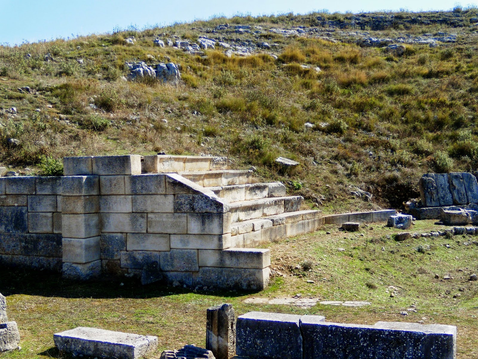
Pretty soon, I arrive at the recognizable Forum – no doubt built on top of the Hellenistic Agora - surrounded by an L-shaped Stoa, two stories high. The earliest agora has been dated to the second quarter of the 3rd century BC, and the 11.4 meters-wide Stoa ran over a total length of 144 meters: the eastern wing (partially cut out of the rock) was 37 meters long and the southern wing 73 meters. The supporting columns were of Doric order, with hexagonal columns on the ground floor, while Ionic columns on the upper floor supported the roof. The set-up of this Stoa is inspired by the one at Apollonia (see: Along the Via Egnatia: Apollonia). Later, the Byzantines built their basilicas inside and in between these remains, meaning that one has to be alert when looking at stones and walls, but the typical Byzantine crosses on column capitals and altar slabs are very helpful.

Comfortably nestled against the hillside, most of the theater has survived, although it has been used as a quarry by the Byzantines.  The original Greek theater was built in the middle of the 3rd century BC and counted 40 tiers, providing seating for as many as 7,500 spectators, which, based on the size of Byllis, means that visitors from neighboring towns attended the performances. It is said to resemble the theater of Dodona in neighboring Epirus, but I am not in a position to compare. Clearly, this theater has been “updated” by the Romans, who added the skena of which only the foundations remain. A corner of the seating area has been reconstructed to give a better feel of the building, and it is interesting to look around for the many details of decorations for the walls, seats, and the trimmings of the skena. I find it striking that the VIP seats are still present around the orchestra in Greek fashion, meaning that this theater was never adapted to be used for animal fights, as the Romans generally loved to organize. The view from up here is, as always, breathtaking!

Turning away from the steep edge on which the theater stands, are the remains of the arsenal, also from the 3rd century BC, and reconstructed during the 1st century AD using the so-called opus reticulatum technique (square diamond-shaped tufa blocks positioned with their corners downwards). It lies about three meters below the adjacent prytaneion (sacred meeting place) and measures 18.2x6.2 meters. This prytaneion, dedicated to Artemis, in turn, is 20 meters long by 6 meters wide and may well be one of the earliest buildings in the Agora.

Byllis also had a stadium from the end of the third century BC, one of the strangest constructions I have ever seen. Only one side of this stadium has been preserved. From the original length of 190 meters, the bottom seating stairs have survived over 134 meters. Near the theater, we can find as many as 19 steps still in place, but overall, there are no more than three or four. But what makes this track so unique is that it runs alongside a huge public water cistern of 51 meters and 4.2 meters wide. This means that this vaulted cistern with a capacity of about 1,200 m3 was constructed underneath the stadium itself. The water was collected from the roofs of the Stoa and from the stairs on the south side of the stadium. In Byzantine times, Emperor Justinian built his baths right next to this cistern, and the facilities were used till around 550 AD.

Remarkably, some remains of private houses have been excavated as well, both Hellenistic and Roman, which I think is rather unusual. Hellenistic houses are rare, and I’m glad to find a clear layout for one of them. It dates from the third century BC and measures 30m x 25m. It is built around a central courtyard of approximately 10m x 10m surrounded by colonnades behind which we find the various rooms; typically, it had its own well (see also: Olynthus and its houses).

All in all, I find it strange that neither here at Byllis nor at any of the other ancient cities in the area (Apollonia, Brundisium, Buthrotum, Dyrrhachium) so little remains from the Macedonian occupation of Alexander and his father, Philip II, before him. Obviously, neither king was there to build a city as their only purpose was to submit the Illyrians as a whole, but since it was the Greeks who colonized this region in the first place, it is awkward to find only sporadic remains of that period – unless the Romans have thoroughly destroyed the buildings that existed previously in those settlements.

[Click here to see all pictures of Byllis]

Saturday, April 11, 2015

The surprise of Butrint, ancient Buthrotum in Epirus

Under Roman rule, the Via Egnatia strategically connected Byzantium via Thessaloniki to Rome thanks to the crossing of the Adriatic Sea between Dyrrhachium and Brundisium. But there was another lesser road that led south to the city of Buthrotum, modern Butrint, right across from Saranda, one of the newest bay resorts in Albania.


Yet Buthrotum was not born with the Romans but like most towns in the area, it was founded by colonists from Corinth and Corfu at some time during the 7th or 6th century BC – although according to the legend its founder was a son of King Priam of Troy, which is a more noble ancestry, of course. To me, this is Epirus, the homeland of Queen Olympias, Alexander’s mother and it is not surprising that in her days the city was important enough to have a sanctuary dedicated to Asclepius with its own theatre and agora; besides, it was protected by a city-wall with five entrance gates.

For some reason, I always thought that all of Epirus was part of modern Greece, but it seems that this ancient country has been split up between Greece to the south and Albania to the north. All I knew about it was the oracle of Dodona, so it is a surprise to hear that Buthrotum was important before the arrival of the Romans. The main attraction may well have been the sanctuary of Asclepius, which was built on a series of terraces rising from a paved area in front of the theatre. The reconstruction as shown on the billboard at the entrance of the site is very clear, but it is much harder to find pre-Roman evidence on the site itself. The sanctuary included a temple, a stoa, and a treasury, all modified by the 3rd century BC to include a theatre and a building that may have served as a hotel for the pilgrims.

As early as 228 BC, Buthrotum became a Roman protectorate, and its influence spread steadily till the city was included in the province of Macedonia. Julius Caesar thought it was an appropriate place to settle his veterans after fighting Pompey in 44 BC, but a wealthy local landlord, Titus Pomponius Atticus, objected to these plans and went so far as to plead his case at the Roman Senate through his friend, the orator Cicero. He was successful, and only a small number of settlers were relocated to Buthrotum. They blended in pretty easily with the locals, and their presence left a definite Roman stamp on the city.


It seems appropriate to take a closer look at Titus Pomponius Atticus, one of the richest men of his time. He lived in Athens for almost twenty years (hence the name Atticus) and showed great interest in Greek culture and philosophy. He bought an estate near Buthrotum and probably acquired more land in neighboring Epirus and Corfu. Although his villa is explicitly mentioned in his correspondence with Cicero, it has not yet been found, but it is generally accepted so far that it was situated in the river valley, where cool breezes soften the heat of summer. Atticus’ wealth, which he acquired as a financier and by managing his land properties, gave him great influence in politics as we have seen above. He was a gifted politician who managed to remain on good terms with both parties involved, the Romans and the locals. He died in 32 BC, aged 78, shortly before the Battle of Actium. Five years earlier, he gave his daughter Caecilia in marriage to Agrippa, Augustus friend and general. Consequently, Atticus’ influence continued after his death through his son-in-law.

In 31 BC, Emperor Augustus conceived plans similar to those of Caesar for after his victory over Marc Anthony and Cleopatra at Actium (some 200 km south of Butrint), he considered Buthrotum to settle his veterans. Once again, the new arrivals, though limited in number, blended in well, and the city expanded rapidly, doubling in size even. At this stage, Buthrotum required a major building plan, which was funded by Augustus in person as well as by his family or private parties. The main projects were the construction of a new aqueduct to feed the many fountains and bathhouses, and a bridge across the Vivari Channel. At this stage, the city appears as Colonia Augusta Buthrotum. Most of what we see today at Butrint may date from Augustus reign since statues of the emperor and of his wife Livia have been found – a sure sign of the city’s loyalty and support.

As in any excavation site, the theatre is what we see first. Although the earliest construction goes back to the 4th century BC, when it was part of the Sanctuary of Asclepius, it was clearly rebuilt and enlarged during the 2nd century AD to become the Roman centerpiece of the city. Today, the lower part of the theater, mainly the stage, is flooded by groundwater, adding a romantic touch with its reflection in the pool. Unique are the many manumission inscriptions that have survived on the outside walls of the theater, dating from shortly after 232 BC. The freeing of slaves, which seems to have lasted for sixty years, was accomplished in the name of a god, generally Asclepius, hence the close link between the theater and its inscribed walls with the treasury of which close to nothing remains.

Behind the cavea of the theater are the remains of the Roman Baths, which are also flooded. Part of the hypocaust is being preserved, exposing some of the fire-resistant bricks used in the floor heating – always an exciting element, I’d say.

The Forum is located next to the theater and the Baths, and originally was located at the heart of the Hellenistic city. In those early days, i.e., late 2nd/1st century BC, it measured a modest 4.5 x 25 meters. Towards the 2nd century AD, the area was enlarged to the size we see today, 52 x 20 meters, but most of it still remains buried.

Further down the island, around the corner of the abovementioned buildings, are the remains of a rather imposing Nymphaeum that must have lined up with the Roman aqueduct that ran across the Vivari Channel and the valley floor to the hills from where the water was transported. Thanks to one of the billboards, I am able to locate the header tank of this aqueduct on the other side of this channel. The spring itself has not been located with certainty, but it seems to be found near Çuka e Aitoit (Eagle Mountain), a rough 12 km away. This fountain, once enhanced with statues of Dionysus and Apollo, appears to lean against the city wall, basically built in the 6th century AD but mixed with remains of earlier Roman constructions. The access to the Vivari Channel, however, was preserved as there are several entrance gates in this wall, still easily recognizable. Today, it is a very peaceful water channel where time seems to have come to a standstill. It is not certain, but this aqueduct may well have served as the first bridge across the channel, and as such, adding to Buthrotum’s status since the city was now connected with the wider Roman world. Aqueducts were very costly enterprises, and only rich cities or those sponsored by private patronage could afford them. Great cities like Athens or Corinth, for instance, didn’t have any aqueducts till the rule of Emperor Hadrian! That definitely proves how wealthy and how important Buthrotum was in its heyday!

This is also the area once occupied by the Gymnasium, but which in Byzantine times was filled by the Great Basilica and its dependencies. It is here that we find a Baptistery from the 6th century AD with an exquisite mosaic floor, covered for its own protection, which is unfortunate for us visitors. It consists of seven circular bands around the baptismal font, thus creating the figure eight, the Christian number for salvation and eternity, I am told (although I have not encountered this explanation before). The mosaics show animals (representing land), birds (representing air), and fish (representing water), in accordance once again with early Christian symbols of salvation. The entrance is flanked by two mosaics of large peacocks (symbolizing paradise and immortality) with a vine growing out of a vase (symbol for the blood of Christ).  Apparently, the roof of this Baptistery was supported by two circular rows of columns, of which only the bases remain. It is worthwhile to mention that this is the second-largest Baptistery in the Eastern Roman Empire after the Aya Sophia in Istanbul.


From the 3rd century onward, Buthrotum started to decline, and a severe earthquake destroyed large parts of the city. It shrank, and a new, smaller city wall was needed. The relief of the so-called Lion Gate on the road to Epirus, which was added in the 5th century to reduce the size of the gate, is a clear illustration. Even an untrained eye can see how this wall has been altered time and again, with steps leading nowhere and dead-end tunnels. When Buthrotum became the seat of a bishop in the 6th century, the Baptistery and Basilicas mentioned above were built, and at the same time, the city walls were reinforced.

But like its neighbors, it was attacked and sacked by the Huns. Over the following centuries, Butrint was occupied in turn by several foreign forces till it turned into a malaria-infested swamp.

The very top of today’s Butrint is crowned by a castle that was reconstructed over the ancient acropolis and now serves as a museum that badly needs some improvement or modernization, unfortunately. It houses finds from Butrint itself but also from other nearby sites, showing some pieces from the Hellenistic occupation but mostly from the prosperous Roman period.

Today, a flat barge ferries men and cars across the Channel to the Vrina plain on the other side. In Roman times, that was the location of a thriving suburb of Buthrotum where the rich and famous had their vast residences. It is here that archaeologists are looking for the remains of Titus Pomponius Atticus’ estate. Work in progress …

Tuesday, March 17, 2015

Along the Via Egnatia: from Ohrid to Elbasan in Illyria

The Via Egnatia entered Illyria at Ohrid in the east, then ran through Elbasan, from where one arm connected directly to Dyrrhachion (see: Along the Via Egnatia: Dyrrhachion in Illyria). Another one diverged to Apollonia and Antipatrea (Berat) to end also in Dyrrhachion on the Adriatic coast, where ships ferried people and goods to Brundisium (Brindisi) on the Italian side. As mentioned earlier, the Via Egnatia was built by the Romans in the 2nd century AD and served as a major connection between Byzantium and Rome (see: Via Egnatia, a road to remember).  

The first traces of Ohrid go back to the conquest by Philip II of Macedonia, Alexander’s father, when the city was still called Lychnidos. After a first truce with the Illyrian King Bardylis that was sealed in 360 BC by marrying his granddaughter Audata, Philip attacked in force in 357 BC, killing some 7,000 Illyrians. The outcome was that Philip extended the power of Macedonia all the way to Lake Ohrid, a territory that Alexander inherited. After the tumultuous and unstable centuries after Alexander’s death, the Romans arrived in 148 BC. By the end of the 3rd century AD, most classical and Hellenistic temples were torn down by the early Christians, who built their colossal churches right on top. The very name Ohrid, however, appears for the first time in 879 AD.

Today, Ohrid is part of the Republic of Northern Macedonia and a pilgrimage site because of its many early Christian churches. The city counts as many as 365 of them, and the monastery of Saint Naum (established in 905) may well be the oldest.

Well, this takes me too far away from Alexander’s days, of which close to nothing remains. There is, however, the ancient theatre, built in 200 BC, which is the only one from Hellenistic times since all others in the Republic of Northern Macedonia are Roman. The location of this theatre is, as always, sublime, gently nestled between two hills with a breathtaking view over Lake Ohrid. Unfortunately, only the lower section of this theater has been preserved, and we have no estimate of its seating capacity. It was initially used for gladiator fights, but soon served as an execution place for the early Christians. The locals resented these practices, and after the demise of the Roman Empire, they buried the theater under a thick layer of soil. This is actually the part we are seeing today, which was discovered by accident in the 1980s during construction works.

However, I have not seen any traces of the Via Egnatia here at Ohrid. It is almost impossible to enter the city without passing through one of the two gates in the defensive walls from the 10th century, which the Ottomans continued to use, so this may be a place to look for this famous road.

I had more luck at Elbasan, where the route of the Via Egnatia has been clearly picked up and is even signposted as “The Rehabilitation of the Egnatia Road was funded by the European Union”. It runs right through the city center, and I wonder whether someone did search for its original pavement. It now blends in with the neighboring streets, although it has been established to match the Roman Decumanus of Elbasan. Well, it is exciting anyway to find some traces!

Luckily, Elbasan has more to offer. Outside the city walls, one cannot miss the remains of a Byzantine Basilica from the 5th-6th century, where mosaic floors and painted walls were found. Today, it is a park where the locals linger in the shade of the trees and drink from the adjacent well, decorated with slabs recuperated from the basilica. The city walls here are quite impressive and in a good state of conservation. The first to protect the city was obviously the Romans, who, in the 3rd or 4th century, built a substantial fortress with towers. Later, Emperor Justinian improved the fortifications, which were, however, of no use against the repeated attacks of the Huns and other invaders from the north. Reconstruction started under Sultan Mehmet II in 1466, and Elbasan remained a main Ottoman center for the next 450 years or so. This means that these sturdy walls were maintained till the early 20th century, and it shows.

So, in the end, there is still a lot of work to do in order to map this famous Via Egnatia. I hope that in time, more of its itinerary and pavement will surface.

[Click here to see all my pictures of Ohrid]

Thursday, March 5, 2015

Along the Via Egnatia: Dyrrhachion in Illyria

Except for the significant remains in Apollonia, which I discussed earlier (see: Along the Via Egnatia: Apollonia in Illyria), the other cities along the Via Egnatia have little remains to offer, merely indications of where to find its course. As poor as those remains are, I am trying to gather as much information as possible in this corner of Illyria (today’s Albania), stopping this time at Dyrrhachion.

As mentioned before, the Via Egnatia (see: Via Egnatia, a road to remember) was built by the Romans in the 2nd century AD and was the main road between Byzantium and Rome. As far as Illyria, the road came from Ohrid (Republic of Northern Macedonia) in the east and then ran through Elbasan, from where one arm connected directly to Dyrrhachion (Dürres). Another one diverged to Apollonia and Antipatrea (Berat) to end also in Dyrrhachion on the Adriatic coast where ships ferried people and goods to Brundisium (Brindisi) on the Italian side.

This time, I’m stopping at the most western end of the Via Egnatia on the Illyrian side of the Adriatic Sea, i.e., at the city of Dyrrhachion situated at the narrow in the Adriatic Sea right across from Brindisi, some 200 km to the west. The only significant testimony from antiquity that is left for us to see is the Roman amphitheater from the first half of the 2nd century AD, and even this is incomplete since there are still modern houses sitting on top of it. Yet it is rather interesting to wander through the vaulted corridors, discovering even a small Byzantine chapel. The oval amphitheater reached its longest diameter of 120 meters and stood originally 20 meters high. It offered seating for 15,000-18,000 spectators who watched gladiator fights, animal combats, or other artistic shows. It is sad, though, to see that all the seating material has been removed – most probably reused somewhere else. Yet in spite of its bareness and partial excavation, it is a most impressive construction.

As early as 627 BC, the first colonists from Corinth and Corfu founded the city of Epidamnos, named after the Illyrian King Epidamnos, its co-founder. The king’s daughter had a son who received the name Dyrrhachion, and it was this name that stuck. Dyrrhachion was the ideal location for a city, built around a natural harbor with high cliffs and protected on the land side by swamps.

Obviously, the envious Romans had their mind set on this prosperous city and after a fierce fight with the Illyrians in 229 BC, they took possession of the city, which they renamed Dyrrhachium, modern Dürres.

Dyrrhachium was the site of a battle during Caesar’s Civil War on 10 July 48 BC. He faced Pompey, who came out victorious, although not for long. The decisive battle of the Civil War was fought at Pharsalus in Central Greece on 9 August of that same year. This battle eventually led to Pompey's assassination on 3 September 48 BC. Another waste of lives in history …

Emperor Augustus turned the city into a colony for his veterans after the Battle of Actium, proclaiming it to be a free town. By the 4th century, Dyrrhachium became the capital of the Roman Province of Epirus Nova, but it was soon hit by a severe earthquake that destroyed the city’s defense walls. They were almost immediately rebuilt to a height of 12 meters and were wide enough for four horsemen to ride abreast on them. The remaining portions of the wall from the fifth century are still in place but have lost most of their strength and were first reshaped by the Byzantine Emperor Anastasios I after the catastrophic earthquake of 345 AD. He defended the city with three rows of walls guarded by consecutive fortification towers every 60-65 meters. During later occupations, the walls were modified several times. Dyrrhachium did not escape the repeated attacks by the Huns, but in Byzantine times, the city gained importance as a major link with Western Europe once again. 

There are no traces of the Via Egnatia in Dürres, but I am pointed towards a tall apartment building near the beach that supposedly stands on top of it. The nearby lonely Venetian tower from the 15th century is said to be built over an earlier Byzantine construction while reusing its stones. It stands nine meters tall with a diameter of 16 meters and is surrounded by intriguing modern pebble mosaics with birds and fish moving around in a black-and-white pattern.

[Click here to see all my images of Dürres]

Wednesday, February 18, 2015

Along the Via Egnatia: Apollonia in Illyria

The Via Egnatia, as mentioned earlier (see: Via Egnatia, a road to remember), was built by the Romans in the 2nd century AD and served as a major connection between Byzantium and Rome. As far as the Illyrian part is concerned, the road came from Ohrid (Republic of Macedonia), then ran through Elbasan, where it split in two, one arm connecting directly to Dyrrhachion (Dürres) and another one crossing Apollonia and Antipatrea (Berat) to end also in Dyrrhachion on the Adriatic coast where ships ferried people and goods to Brundisium (Brindisi) on the Italian side. 

To name a city after the sun god Apollo seems to have been very popular in Greek history as we find several cities by the name of Apollonia in Turkey (Lycia, Mysia, Pisidia, etc.); in Sicily, Italy; in Greece itself (Thessaloniki, Chalcidice, Kavalla, etc.) and in Crete; in Libya, where it was the harbor of wealthy Cyrene; and finally here in Illyria, modern Albania.

This time, I’ll be concentrating on Apollonia in Albania, located about 7 kilometers from Fier (see: Alexander’s psychological warfare in Pelium, Illyria). The city is well documented during Roman times, and the remains are obviously very Roman too. For Alexander, this was deep into the Illyrian country, just beyond the northern border of Epirus.

The original name was Gylakeia, after its founder Gylax, who belonged to the Illyrian tribe of the Taulantii. It was the Greek colonists migrating from Corinth and Corfu in 588 BC who changed the name to Apollonia. They were the ones who controlled the city and ruled over the Illyrians. Money was made from the slave trade and agriculture, but maybe mostly through the supply of asphalt, which was a valuable material for the caulking of ships in antiquity. Located on a branch of the Via Egnatia, it is obvious that it was an important harbor along the Illyrian coastline to link up with Brindisi on the other side of the Adriatic Sea and a transit port for all kinds of goods traveling between Byzantium and Rome.

This is the area where King Pyrrhus (a great-nephew of Olympias and cousin of Alexander the Great) ruled roughly from 306 to 272 BC while mingling in Macedonian affairs in the wake of the Diadochi Wars. He tried to keep the Romans out of Illyria, but by 229 BC, they firmly established themselves. I find it rather strange that Apollonia, like so many other Illyrian cities, was so loyal to the Romans. Maybe that is because the city was rewarded with the booty taken from their defeated King Gentius of Illyria – not very patriotic, I would say. By 148 BC, Apollonia became part of the Roman province of Macedonia, Epirus Nova. About a century later, the city supported Julius Caesar in his war against Pompey but fell into the hands of Brutus in 48 BC. Apollonia could also claim to have contributed to the education of Emperor Augustus, who studied at its famous school of philosophy in 44 BC, where Athenodorus of Tarsus was his teacher. Together with other cities in the area, Apollonia flourished and was even mentioned by Cicero as “magna urbs et gravis”, meaning “a great and important city”. Strabo also mentions the city in his Geographica as “an exceedingly well-governed city”. Decline set in during the third century AD when its harbor started silting up after being hit by a severe earthquake, which changed the course of the Aoos River. The inland turned into an ever-growing malaria-ridden swamp, and the inhabitants moved out to resettle at nearby Avlona (modern Vlore).  Only a small Christian community that moved in during the very early days of Christianity remained; they may have built the first church of Saint Mary. Today’s church dates from the 14th century and houses the local museum.

The visitor’s attention is immediately drawn toward a colonnaded façade that could be part of a temple. Still, it turns out to be the entrance to the Bouleuterion from the second century AD – quite unusual since generally, the tiers of such a city council survive but not the portal. The columns are definitely Corinthian, and in the architrave above them, we can still read the Greek dedication: “To the memory and in honor of Valentinus Villius Furius Proculus from his brother Quintus Villius Crispinus Furius Proculus, prefect of a cohort in Syria, tribune of the Legion Gemina in Pannonia, and president of the sacred games. A fight of 25 gladiators was held for the inauguration.” This Bouleuterion is surrounded on three sides by rooms, some kind of annexes to the Ionic Temple next to it. What is left are mainly low walls, and archaeologists suppose that these rooms were used for administration or for the priests’ duties. The outlines of the temple itself are easily located with a few columns sticking out from the grass.

Across from the Bouleuterion are two big stumps of stone indicating the site of a triumphal arch at the end of the street leading into Apollonia and dating from the 3rd century AD. To the right, but difficult to make out, are the remains of a Library from the 2nd-3rd century AD, proof of the city’s importance – if needed. On the other side of the street lies an Odeon that has been carefully restored and could hold as many as 650 spectators. Adjacent is a small Sacellum, an open sanctuary dedicated to an imperial cult. The niche was most probably flanked by two Ionic columns, and we still can see the rosettes and lion paws of their base.

It is followed by a portico, 78 meters long, punctuated by 17 niches that once held marble statues. This portico seems to date from the 4th century BC and was divided lengthwise into two by a row of Doric columns, whereas the outside columns were of Ionic style. I am told that this kind of structure is unique for Apollonia.

The portico ends at the Sacred Road, where we find a temple right around the corner, dating from the second half of the 2nd century BC but probably renovated four centuries later and possibly dedicated to Jupiter, Juno, and Minerva. The Sacred Road continues further uphill to the Acropolis, where little or no excavations have been done. With a width of nine meters, it is the widest street so far in Apollonia, paved with river pebbles laid directly on the clay surface.

On the other side of this Sacred Road are three vaulted shops, almost square in shape (3.45x3.40m), whose entrance could be closed by heavy double doors. The walls were very thick to keep out the moisture and guarantee a nearly constant temperature in order to preserve the goods stocked inside. They seem to have been built during the second half of the second century AD. Against these shops, another construction deserves our attention, for this is a water cistern that was used from the 4th century BC all the way to the 2nd century BC and has still kept its impermeable inside coating.

Opposite this Sacred Road are the remains of a large villa, in fact, no more than a succession of mosaic floors. The house was divided into four parts: an entrance portico of 14x5.8 m right opposite the Sacred Road; the main room measuring 12x11.8m with a center of white mosaics surrounded on all four sides by a corridor 2.9 m wide paved with little brick squares of 5x5 cm; the back room overlooking the sea. It is thought that this house was used as a gathering place for the believers before starting their procession over the Sacred Road. The most precious mosaics have been covered, of course, but the remaining ones are quite interesting. The attentive visitor will also notice the clearly Roman sewage system running parallel to this building.

Like every single Greek city, the location of Apollonia was chosen with the greatest care, overlooking the Aoos River and its fertile valley with the Adriatic Sea at the far horizon.

My greatest surprise, however, was the local museum, housed in the 14th-century monastery attached to the church of St Mary, by itself worth a visit. Under the watchful eyes of the soaring Pantocrator, it is easy to discover all sorts of antique fragments: Corinthian capitals placed upside-down to serve as a base for some Christian relic or flowers; the marble wall of a well with deep gutters left by the ropes that pulled the water-buckets over the centuries and now on dry land; small lidless sarcophagi turned into mini-gardens; and other spolia spotted in the outside walls. In the upstairs portico leading to the very entrance of the museum, several grave steles and smaller altars have found refuge.

Since I have been walking through Roman Apollonia, I expect this museum to reflect that image. Well, not entirely so, for originally, the city was founded by Greeks who imported the art from their hometowns or created their own imitation. I walk among Attic vases and hydras from the 5th century BC, Apollonian bottles and pots, but also some Italic imports. The Hellenistic period is also very present with several marble steles, reliefs, busts, and statues, but the eye-catcher is this wonderful shield that I immediately recognize as Macedonian. But wait a moment … according to the label it seems to be Illyrian! How on earth is that possible? I take a closer look at this splendid piece with three concentric circles in its center, around the frightening head of a Gorgon in Classical Greek style, sticking out its tongue and staring at me with shiny inlaid eyes. The border of the shield also counts three concentric rows of circles framing six half-circles around the edge. I fail to see what makes it Illyrian and inquire with the museum director, who tells me that the difference lies in the curving. Well, I suppose he knows, but I am not entirely convinced till I see other examples of Illyrian shields later on in Tirana and at the Skanderberg Museum. I’m totally baffled by this revelation! Ironically, the Illyrian shield in Apollonia is presented next to a splendid Macedonian helmet that has been dated to 314-312 BC, a rather narrow timeline.

So, all in all, Apollonia was definitely worth a visit, including the local museum. Some artifacts, however, have been moved to the national museum at Tirana, where I discovered a hoard of silver drachmae from the 1st century BC, as well as a head of Demosthenes (1st century AD) – of all people, what is he doing here?

I’m not too far away from Alexander, after all!