Alexandria's founded by Alexander

Alexandria's founded by Alexander the Great (by year BC): 334 Alexandria in Troia (Turkey) - 333 Alexandria at Issus/Alexandrette (Iskenderun, Turkey) - 332 Alexandria of Caria/by the Latmos (Alinda, Turkey) - 331 Alexandria Mygdoniae - 331 Alexandria (Egypt) - 330 Alexandria Ariana (Herat, Afghanistan) - 330 Alexandria of the Prophthasia/in Dragiana/Phrada (Farah, Afghanistan) - 330 Alexandria in Arachosia (Kandahar, Afghanistan) - 330 Alexandria in the Caucasus (Begram, Afghanistan) - 329 Alexandria of the Paropanisades (Ghazni, Afghanistan) - 329 Alexandria Eschate or Ultima (Khodjend, Tajikistan) - 329 Alexandria on the Oxus (Termez, Afghanistan) - 328 Alexandria in Margiana (Merv, Turkmenistan) - 326 Alexandria Nicaea (on the Hydaspes, India) - 326 Alexandria Bucephala (on the Hydaspes, India) - 325 Alexandria Sogdia - 325 Alexandria Oreitide - 325 Alexandria in Opiene / Alexandria on the Indus (confluence of Indus & Acesines, India) - 325 Alexandria Rambacia (Bela, Pakistan) - 325 Alexandria Xylinepolis (Patala, India) - 325 Alexandria in Carminia (Gulashkird, Iran) - 324 Alexandria-on-the-Tigris/Antiochia-in-Susiana/Charax (Spasinou Charax on the Tigris, Iraq) - ?Alexandria of Carmahle? (Kahnu)
Showing posts with label Hippodamus. Show all posts

Saturday, December 10, 2016

The Hippodamian plan, not so Greek after all

Where does an idea originate? Who is the first to “invent” this or that concept? In our modern world, we often hear that the true inventor is not the one who claims the invention to be his, either because the initial creator did not have the means to promote his idea or because he simply didn’t protect it with a copyright.

In antiquity, copyright did not exist, of course, and ideas traveled back and forth in the baggage of the merchants or in the minds of the craftsmen sold as slaves or moved from their homeland for whatever reason.

The grid plan of city building is largely attributed to Hippodamus of Miletus, a Greek mathematician, meteorologist, philosopher, and physician from the 5th century BC, who also was known as a town planner. He planned the building of many cities around the Mediterranean, the first of which could be the harbor of Piraeus. He also was involved in the reconstruction of Miletus after the Persian destruction, to be followed by the construction of cities like Olynthus and Pella in Greece. His ideal city would be inhabited by 10,000 male citizens, which would correspond to a total of 50,000 people including women, children, and slaves. It would typically have a large central area that soon became the agora, surrounded by neighborhoods of 240 m2 blocks of houses with an upper floor and separated by a wall, all facing south.

Digging a little further into history, it turns out the layout of Babylon was equally following the same grid plan with right-angle streets and the city must have looked very familiar to Alexander when he arrived there in 331 BC. Although Babylon is much older, the city was rebuilt by the Assyrians who made it the capital of their Neo-Babylonian Empire between 609 and 539 BC. King Nebuchadnezzar II, who reigned from 605 to 562 BC, added the famous ziggurat and the Ishtar Gate, one of the eight entries to the city. The Hanging Gardens, which counted among the Seven Wonders of the Ancient World, were also constructed by him. Based on the available descriptions of Babylon, the grid plan was already known in Asia over a century before Hippodamus claimed his “invention”.

Yet, there is more to the ancestry of the so-called ideal Greek city layout. We have to go back 4,500 years in time and all the way to the Indus Valley where cities like Mohenjo-Daro and Harappa were founded using the very same layout. These cities had a central agora, large public baths, a large central well, and many small wells serving individual houses or a cluster of houses; the sewage was led to drains running under the main streets and many houses had their own bathroom. Both cities were large settlements belonging to the Indus Valley Civilization and located on the banks of the now dried-up Ghaggar-Hakra River, west of the Indus River.

With the coming of Islam and the general decline of the Middle Ages, we in the West lost this marvelously well-organized city planning till it was revived in the 20th century all over the globe, from Asia to the Americas. Pending whatever discoveries will be made in the future, for now, Hippodamus “invention” is just some two thousand years older than generally accepted.

Monday, April 6, 2015

Priene, delightfully Greek

Unlike so many remains of Greek settlements, Priene has not been turned into a Roman city. What a delightful blessing!

Priene, like neighboring Miletus and Ephesos, was part of the Ionian League, regrouping twelve city-states that existed already before 1000 BC. Around 450 BC, the city was designed by the same architect as Miletus. His name was Hippodamus, after whom the well-known and most popular Hippodamian plan was named and used all over the Hellenistic world.

Priene was occupied in turns by Athens and Persia, but after the death of King Mausolus in 353 BC the city fell under Athenian rule. It is said that Alexander stayed here in 334 BC while besieging Miletus. It is in Priene that he received the embassy led by Glaucippus, a well-respected citizen of Miletus, who suggested leaving the harbor available to both Persians and Macedonians at will. This did not fit Alexander’s purpose; keeping an important port as Miletus open to the Persians was far too dangerous in his eyes. Alexander must have spent several months in Priene which had willingly surrendered to the Macedonian King for Miletus was a tough nut to crack (see: Miletus, Alexander’s first siege in Asia).

Priene occupies an impressive location and can be spotted from afar. It is nestled against Mycale Mountain, and the location somehow reminds me of Delphi. A steep and stepped road runs upwards to the city walls, two meters wide and six meters high. The spaced freestanding watchtowers are rather exceptional for this meant that they could easily be rebuilt in case of destruction. The rampart and the city gate are what the visitor sees first after a pretty strenuous climb – impressive!

The main road inevitably leads to the Hellenistic theater built at the same time as the city itself seating 5,000 visitors spread over 50 rows and resting against the gentle mountain slope. Five marble VIP seats around the orchestra are still in place and were not removed as usual during Roman modifications. Across from the theater lies the upper Gymnasium from the 4th century BC and several later Byzantine buildings.

Further down the street, one can hardly miss the Temple of Athena with its slender bluish-grey marble Ionian columns pointing to the sky that were reassembled thanks to the many drums lying around. Pytheos, who also was the architect of the famous Mausoleum of Halicarnassus, had just started building this temple when Alexander arrived. As a matter of course, the King immediately financed its construction, and a dedication to that effect, now at the British Museum in London, reads “King Alexander has dedicated this temple to Athena Polias. How unique that this testimony survived the centuries for it makes Alexander’s presence almost palpable. The temple measured 19.55x37.20m and had eleven columns lengthwise and six for its width. An altar of Athena Polias including the relief of a Muse from the 2nd century BC has been unearthed and is now on display at the Pergamon Museum in Berlin.  Pytheos never finished the job and the temple was finally completed by Emperor Augustus who from then onward was worshiped here together with Athena.

In the next city block, we find the remains of a 116-meter-long Sacred Stoa, erected between 130-112 BC. The Stoa’s wooden roof was as so often supported by two rows of columns, Doric on the outside and Ionic on the inside, splitting the more than twelve-meter-wide promenade in two. This Stoa ran parallel with the 75-meter-long Agora that was reached by six steps since the square laid about 1.5 meters lower. One end of the Agora was reserved for the fish and meat market and the other end was occupied by a temple dedicated to Zeus or Asclepius.

Just behind the Sacred Stoa is the Bouleuterion, a square Council Hall seating 640 delegates and the best-preserved building in Priene. The auditorium is surrounded on three sides by rows of benches, 16 on the north side and 10 on either side. In the center of this Bouleuterion from the 2nd century BC, stands an altar decorated with wreaths and bullheads. The original columns supporting the protecting wooden roof are still in place. The adjacent Prytaneum where daily administrative operations were carried out is more difficult to find. The only indication is a stray column with an inscription since this was the Sacred Heart of the City that kept the eternal burning sacred fire.

The street running along the Agora ends at the western city gate and is lined with private houses. It is believed that Alexander lived in one of the houses on the left-hand side, probably because a statue of the conqueror was found there; yet there is no hard proof for this theory, however, tempting it sounds! The statue moreover dates from the 2nd century BC and can be seen at the Altes Museum in Berlin. The house itself, nicely sign-posted, is not different from its neighbors in the street, except maybe for the sacrificial table found in one of the smaller rooms. Moreover, this street is surprisingly Greek with the gutter running on the side of the pavement, very much unlike Roman roads.

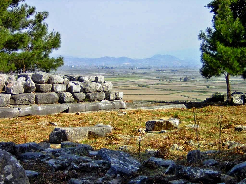
During my very first visit, I had not looked into the geographical situation of Priene, and standing here high above the vast flat plain below, I instantly realized that this was an alluvial plain created by a river (in this case the Maeander). This means that in Alexander’s days, all the land below was sea and that in order to reach Miletus he had to make quite a detour, skirting the eastern foothills. Priene itself never had direct access to the sea, and its harbor was the nearby town of Naulochos. How strange to be reading history like this. The islands mentioned by ancient writers are now reduced to mere bumps in the landscape as pointed out by Peter Sommer during my next trip.

After Alexander’s victory over the Persians, Priene like all the other Ionian cities widely prospered. A small testimony of its wealth can be found at the Altes Museum in Berlin where we can admire some splendid statues of Dionysus, Aphrodite, and an unknown young man.

Of course, not much of the city dates from Alexander’s days but it definitely is Hellenistic and not “spoiled” by the Romans. This makes it quite a unique place to take in. So much history has been written in Priene and yet only a few tourists bother to stop here, while the city is so filled with past sounds of the Macedonian army and if you listen carefully, the soft breeze may still carry the name of Alexander.

Tuesday, March 10, 2015

Miletus, more than a city

When writing about Miletus, it is obvious to tackle the remains of that once so great city and to place them in their historical context – in my case, especially around Alexander the Great (see: Miletus, Alexander's first siege in Asia). But Miletus is much more than just a city of stone; it actually produced many of the brightest minds of antiquity.


Miletus greatly surpassed the other cities on the Aegean coastline of Ionia and founded as many as thirty (or ninety, depending on the sources) cities around the Black Sea, the Hellespont, and the Sea of Marmara. The city also possessed a trading post in Naucratis, the Greek settlement on the Nile delta dating from the seventh century BC. This created envy among the Persians, who, after the defeat at Plataea in 479 BC, took their revenge by thoroughly destroying Miletus.

The city bounced back and was flourishing once again by the middle of the fifth century BC. Thanks to its busy and prosperous harbors, Miletus came into contact with older and more advanced civilizations, such as that of Egypt, from which they copied the idea of dividing the year into twelve equal parts. From Mesopotamia, they obtained the gnomon or shadow marker, which led to the first sundials that divided the day into twelve parts as customary in Babylon. Ishtar, the Babylonian goddess of fertility, was recognized by the Greeks as Aphrodite and used to identify the bright Venus star we all know. This means that there was a wealth of knowledge available to Miletus and to the rest of the Greek world, the extent of which we can only guess.

But returning to Miletus, the best-known citizen is probably Hippodamus of Miletus, a town planner but also a physician, mathematician, meteorologist, and philosopher, who lived in the fifth century BC. As opposed to confusing and chaotically built cities like Athens, Hippodamus introduced us to city planning with order and clarity, creating wide and straight streets crossing each other at right angles. Many cities around the Mediterranean were built by him or according to his grid plan, later to be known as the Hippodamian Plan. The harbor of Piraeus was one of his first works, but he was also involved in the new city of Rhodes and the reconstruction of Miletus after the Persian destruction. Examples of later dates are, for instance, the cities of Olynthus and Pella in Greece. Hippodamus’ ideal city would be inhabited by 10,000 male citizens, which would correspond to a total of 50,000 people when including women, children, and slaves. It would typically have a large central area that soon became the Agora, surrounded by neighborhoods of 240 m2 blocks of houses with an upper floor and separated by an outer wall, all facing south. Aristotle tells us that Hippodamus’ cities were meant to be divided into three classes: for the soldiers, artisans, and common citizens, just like the land was divided into sacred, public, and private. Yet Hippodamus must have been the hippie of his time with his long hair (not shown in his picture), and expensive ornaments, yet wearing the same clothes in winter as he did in summer.

Isn’t it amazing that today, 2,500 years later, modern cities like Manhattan or Denver were built based on the same principles of what urban architects meanwhile call the checkerboard plan?

Another great name is Thales of Miletus, one of the Seven Sages of ancient Greece who lived a good century earlier, from ca. 625 to 547 BC. He is considered the father of philosophy and is supposed to have calculated the height of Egypt’s pyramids by pacing off their shadow at the moment when their height was equal to their shadow. Thales is credited with inventing geometry, literally meaning “land measurement,” but actually a branch of abstract mathematics. He was also a philosopher, mathematician, and astronomer, reaching into theology with his concept that all things are full of god. Thales speculated on the nature of matter; he believed there was an arche or fundamental substance that always endured. He claimed that the principle was water simply because the earth rests on water (the general belief was that the earth was surrounded by an ocean).

His friend, Anaximander of Miletus (ca 610-ca 545 BC) declared, however, that the arche could not be water because it could not give rise to its opposite, fire. He even went so far as to state that none of the elements (water, earth, fire, air) could be arche for the same reason. Anaximander seems to have been the first to publish a treatise on nature. He also wrote about astronomy, as apparently he was the first to use the gnomon to determine solstices, time, seasons, and equinoxes; he also published a work on geography with the first map of the inhabited world. According to Anaximander, the earth had a cylindrical form and was at the center of the universe.

Anaximenes of Miletus was a younger contemporary and pupil of Anaximander. His theory was that the prime substance was pneuma, i.e., breath or air, which assumes various forms through its eternal motion. He provided a theory of change that was supported by observation. Rarefied air becomes fire, condensed it becomes first wind, then clouds, and after further condensation water, then earth, and eventually stones. Anaximenes thought that the earth was flat and floated upon the air like a leaf.

These four men by themselves alone prove that Alexander not only took walls and buildings when entering Miletus but many bastions of knowledge, and I am sure that these were not the only ones that were available at that time, for there is still so much of that knowledge that has not come to us.

[Pictures of the personalities are from Wikipedia]
[Click here to see the full picture album of Miletus]

Sunday, December 23, 2012

Alexandria was born under a regal star

With Christmas just around the corner and the stories about the star of Bethlehem flaring up once again, the time feels right to talk about the "birth" of Alexandria in Egypt, the first grand-scale city built by Alexander the Great.

Alexander founded Alexandria in 333 BC, and it is generally considered the first of the "king's towns." Recent studies by members of the Faculty of Civil Architecture in Milan, Italy, have revealed that the main longitudinal axis of the city, the Canopic Way, is oriented towards the rising sun on the day Alexander was born, and if that were not enough, to the Regulus star that rose in the same direction. This is not a coincidence but an achievement where astronomers and architects, or diviners and builders, worked hand in hand. An exciting revelation that incites us to have a closer look at the foundation of Hellenistic cities.


Despite the statements made by Plutarch and Diodorus, the location of Alexandria was not particularly suitable for building a city. In fact, it was set on a narrow strip of land squeezed between the sea and the marshy lands at the mouth of the Nile's Canopus. Preliminary works are required if we believe what is written in the Alexander Romance, the drainage of several canals before covering the area with streets – at least three of such canals have been located during recent excavation works. Moreover, other excavations in the early 20th century revealed that the Canopic Way was deeply carved out of the underlying bedrock. Nothing was left to chance. 

Alexander never saw his city completed (achieved by Ptolemy, who inherited this part of Alexander's Empire after his death), as it became the home of the famous Lighthouse (one of the Seven Wonders of the Ancient World) and the incomparable Library of Alexandria. Still, from its very start, the place was very unique.

Hippodamus of Miletus, who had revolutionized ancient town planning by introducing a plan that answered to rigorously right-angled streets at mathematically equal distances, had been widely used throughout Greece and Asia Minor since the fifth century BC. Alexander took the very concept one step further in Egypt by adding an element of "cosmic" order.

From the very beginning, the city was designed in all its details with a rather huge perimeter. It was divided into five quarters, labeled with the first five letters of the Greek alphabet. The main east-west road was called the Canopic Way, and the main crossroad was, strangely enough, a dyke (Eptastadion) that connected the isle of Pharos to the mainland. The particularity of this city plan is that this Canopic Way played the role of the city center, with all the official buildings and temples aligned along its 30-meter-wide street instead of being around a central agora. Yet the most striking factor is that this road was not laid out according to local topography but ran slightly off a parallel with the coastline of the Mediterranean.

Thanks to computer calculations, Italian researchers determined the sun's position in the fourth century BC, taking into account that the sun's path in the sky has changed over time because of the variations in the Earth's orbit. This is how they determined that on July 20, 356 BC, the day Alexander was born, the sun rose in near-perfect alignment with the Canopic Way – the "near perfect" being less than half a degree off, a negligible difference. On top of that, they established that "Regulus," the so-called "King's star," i.e., the brightest star in the constellation of Leo located near its head, also rose along the same alignment. This is a clear statement that the city of Alexandria was born under its very own stars, if you include the sun in stardom.

Who would have expected Alexander to take his planning to such a divine stage? And why would he have gone through so much trouble?

One would expect that the Egyptians were responsible for this kind of calculation. After all, they had a long history of associating the sun god Ra with their pharaohs and built the Great Pyramids perfectly oriented to the four points of the compass. Yet that was ignoring the thorough knowledge of Greek mathematicians and astronomers. Only now do we realize that the city's planners did not use the Egyptian solar calendar, which counted 365 days per year, but the Greek lunisolar calendar. Alexander was born on the sixth day of the first month of the New Year, and New Year's Day was the day of the first new moon after the summer solstice, which eventually led us to July 20 in 356 BC. Additionally, the Greeks used the rising of the stars as forerunners of important festivals, which might very well apply to Alexandria.

Is it a surprise or a coincidence that "Regulus," the star associated with the kingship since Babylonian times, rose at the same azimuth on that same day? Knowing Alexander, he would not have missed the opportunity to include such a symbolic moment in the foundation of his new city. After all, he had just returned from Siwahwhere he had been declared the son of Ammon-Zeus. Researchers now agree that Alexandria in Egypt was, in fact, the prototype for later Hellenistic towns designed as "king's towns," meant to refer to the divine power of their founder (and probably to the memory of Alexander).

It is interesting to hear that the Italian team has taken their research one step further to see if this same solar alignment occurred in other cities of the same period within the same cultural context. For that purpose, they examined the foundation of Seleucia-on-the-Tigris and the magnificent funerary monument at Mount Nemrud in today's eastern Turkey.

Seleucia-on-the-Tigris was founded in 300 BC by Seleucos, one of Alexander's generals, who by 305 BC became king of eastern Asia as Seleucos I Nicator (see: Seleucos Nicator, in the wake of Alexander). Seleucia, located as the name says on the banks of the Tigris River in modern Iraq, may be more symbolic than expected at first sight. The city is not far from Babylon, where Alexander died in 323 BC and where Seleucos built his new capital. Just like Alexandria, the foundation of this city is lost among many legends. Seleucos himself was acclaimed as a god, the son of Apollo, and it is obvious that this divine power rubbed off on this city. 

Diodorus described Alexandria's shape as "similar to a chlamys," and Pliny records that Seleucia resembled an eagle. But focusing on Seleucia's main street, the Italian team discovered that its Canopic Way was entirely inspired by that of Alexandria. Archaeological maps and satellite images established that if Alexandria and Seleucia had been on the same latitude, the sun with a flat horizon would have risen in Seleucia in alignment with its Canopic Way on the very same day as it rose in Alexandria. There is, however, a slight difference in latitude between both cities, and the match would occur on July 27 instead – a minimal difference, but still close enough to Alexander's birthday. On top of this solar match, there is also a close concordance with the famous Regulus star.

The Italian professors are therefore tempted to declare that the foundation of Seleucia has been inspired by Alexandria's practical and symbolic perspectives. Being located so close to where Alexander died, it is not difficult to attribute an identical reference to his power several years later. The King's Star only adds to the magic and mystique of the site.


And then there is the case of Mount Nemrud, where a vast funeral monument was built for Antiochus I Commagene. The same story of Hellenistic divinity applies here, although different because we are talking about a tomb and not about a city. Today's location at 7,000 ft is off the beaten path in a relatively remote area of eastern Turkey, but must have been an exceptional place in the first century BC when this monument was built. The two terraces of this tomb are directed towards the summer and winter solstices, and it has been recently figured out that the colossal (now beheaded) statues on the eastern side faced the sunrise on July 23, being the date of Antiochus' ascent to the throne as mentioned in the inscriptions on the monument. Moreover, there is another striking coincidence with Alexandria since Antiochus explicitly refers to Alexander the Great as his ancestor in the inscriptions mentioned above.

Only a few people know this tomb includes a peculiar "lion horoscope" depicting Mars, Mercury, Jupiter, and even the crescent moon in Leo. Most notable is the presence of the Regulus star, which, like in Alexandria, rose at this latitude around July 23 during the reign of Antiochus I.

The above analysis clearly shows that nothing was left to chance when building new cities or important monuments. They include more astronomical elements and references to Megas Alexandros than we would suspect. It would be interesting to see more "Alexandria's" investigated similarly, for I wouldn't be surprised if we found more similar evidence in every Alexander city.

Tuesday, September 20, 2011

Olynthus and its houses

Several months ago, in the frame of the exhibition on Alexander the Great at the Hermitage in Amsterdam, I attended a lecture about Macedonia where one of the subjects treated was the city of Olynthus.

To me, Olynthus was a city repeatedly besieged by King Philip, Alexander’s father, in his attempt to create a united Macedonia. Ultimately, he razed it from the map, flattening the entire place in a final crush. So, it would be interesting to learn more about this part of history. As it turned out, this was not to be the main focus of the lecture, it was to be the houses of Olynthus, and I was in for several surprises!

The town is located in southwestern Chalcidice, covering two flat-topped hills in the middle of a fertile plain, about ten kilometers north of Potideia. The origin of Olynthus goes back to its mythological founder, Olynthus, son of Heracles. Still, the oldest remains date from Neolithic times in the third millennium BC, which were destroyed by the Persians in 479 BC.

We owe it to King Perdiccas II of Macedonia to order local tribes and settlements to move to Olynthus. This population increase led to the city's actual organization, which soon covered the entire north hill. Here, the new town was built according to a grid plan, the Hippodamian plan. Hippodamus of Miletus (498-403 BC), although an eccentric figure in his time, was the father of urban planning. He conceived the city layout with wide straight streets crossing each other at square angles, inevitably leading to an ample space in its very center where the Agora would emerge so the citizens could meet and greet in one central location. The first city to be built according to this principle was, of course, Miletus in Asia Minor. Still, the idea took on rather quickly, and Olynthus and Pella were to be built this way (eventually lavishly implemented by Alexander the Great when he founded his many cities in the east and generously copied by the practical Romans).

From 432 BC onward Olynthus’ power rose substantially to become the leader of the Chalcidian League, a confederation of 32 cities on the Chalcidice peninsula. Both Athens and Macedonia would love to have Olynthus as an ally rather than as their enemy. Still, an alliance with Olynthus never lasted long as they kept changing camp according to their own whims.

In 357 BC, King Philip II concluded a peace treaty with Olynthus and its allies, i.e., against Athens (part of this text is being kept at the nearby Museum of Polygyros). But a couple of years later, Olynthus changed its mind again and sought an alliance with Athens, who in return did nothing or close to nothing to help them. At first, Philip maneuvered in such a way as to isolate Olynthus by taking one neighboring city after the other and thus seriously cutting down its power. In 348 BC, he besieged Olynthus and razed it to the ground. Useless to point out that the speaker in Amsterdam had my undivided attention, and it was obvious I had to see Olynthus for myself on my next trip to Macedonia – which I did.

Because Olynthus has been (nearly) completely flattened, it is easy to get a good overview of its layout. Although hardly 1/10th of the total area has been excavated, two large avenues, 7 meters wide, clearly stand out with smaller streets dividing the city into blocks (a familiar sight in major American cities today!). Each block counted ten houses with one upper floor and a paved yard. Amazingly, some of the earliest floor mosaics in Greek art have been discovered here!

It is surprising to learn that most of the houses have a similar ground plan which is commonly referred to as “pastas houses”, i.e. roughly squares of 17 x 17 meters, divided in two almost equal parts, while the northern half is again divided in two. This means that the walls and supporting columns are all placed according to a common rule required: one single roof covers all the northern halves of the entire row of houses. Life evolved around a central courtyard situated in the southern half, which opened onto the long northern portico, i.e., the “pastas.” This portico was the focal point in each house, a convenient and comfortable working area. Nearly all the rooms opened directly to the court or to the pastas. It turns out that the houses in Olynthus were non-hierarchical, meaning there were no main or dominant rooms or backrooms. This differentiates them from the “prostas” type of houses that the Romans built in later years.


All Olynthian houses had a room dedicated as a kitchen area, sometimes with a built-in hearth, and another small room assigned to bathing as several bathtubs have been found in situ with their drainage system. But what stroke me most during this lecture was the illustration of the rooms used as “andron.” Now the “andron” is a kind of formal dining room, only for men, of course, which was used primarily for the Greek “symposiums.” These were dinner parties in which the host took care of entertaining his guests, deciding on the subject to be debated during the long eating and drinking séances, and making sure the appropriate amount of water was mixed with the wine. There were music players, but also young boys and hetaerae to be at the dedicated service of the guests. After a few hours, it was obvious that things ran out of hand, and the mosaic floors were valuable assets when cleaning up the mess the guests made of food, wine, and vomit. In Olynthus, these “androns” usually were square rooms of approximately 5 x 5 meters, with plastered and painted walls around which a raised border of about one meter high indicates the place for the couches (klinè). Because of their setting against the walls, the “androns” in Olynthus could hold seven “klinè,” which meant that the room entrance was off center. The floor was drained by a pipe running through the walls straight into the street, an efficient way to clean up after a messy revelry.

There seem to be considerable variations in these house plans; some have larger “androns,” others larger kitchens or general rooms. Several houses had special workrooms and shops with an opening to the street. Besides that, the homes on one block could be very distinctive from those on another block, perhaps because of a different social status or people exercising a different trade.

Armed with all this background information, I’m off to see Olynthus for myself! The city is within easy reach from Thessaloniki; driving south till the freeway turns into a local road and making sure to turn left in Nea Moudania instead of driving on towards the peninsula of Kassandra. The antique city, now called Megale Toumba, lies on the eastern side of the river Olynthios, while the modern town has relocated to the opposite side. The place is fenced and the access path equals a walk in the park, which in spring bursts with a wide range of flowers and blossoming bushes of all kinds where the busy bees are having a party.

Soon the road runs uphill, and I am treated to the first overall view over the remains of this once so proud city. The walls are approximately knee-high, mainly thanks to the archaeologists' reconstruction work. They have done an excellent job here, inserting a pinkish layer of cement where the original stones end and the newly restored ones have been added. It is a clear example of what “razed to the ground” means,  as historians tell us, for that would have offered us very little to see. I stare immediately into one of the main streets running slightly uphill, giving the impression of an aerial view. Modern excavators have named these avenues, while the smaller crossroads are labeled as streets. At more or less regular intervals, the excavators have placed boards with pertaining information about the streets and the houses so that even the unprepared visitor will find the answers he is looking for.

I follow one of the side streets to its dead end against the city wall, where the sewage conduct that runs underneath this street continues through the wall out of the city. I now remember how during the lecture I was told that the walls of the town and the houses might have had only stone basis whereas the top part was built in brick or mud. That would partially explain how Olynthus was destroyed to the ground, although it was located in a strategic and well-defendable position. The Olynthians put up a fierce fight! It took Philip nearly two years to conquer the city with a short interruption for a campaign in Thessaly. At any rate, his army found the time to engrave their spearheads with a personal message “ΦΙΛΙΠΠO” from Philip. The king and his army must have had quite a sense of humor! Examples of these spearheads can be admired at the nearby Museum of Polygyros, exciting stuff!

In most houses, the wells have been located and nicely preserved – covered with a grid to keep the absent-minded visitor from falling into the pit. I come across one well with the restored wooden frame around it, very interesting. And then, there are the floor mosaics that were left in their original location. As I mentioned above, these are the oldest examples showing well-preserved geometrical motives framed within typical Greek bands. They are comparable to the better-known mosaics at Pella, although not as “royal,” maybe. I recognize the Macedonian sun in one of them while the corners are filled with volutes supporting the wave pattern around the sun. Another one shows a horseback hunter wearing the typical Macedonian hat as he rides in full gallop like in the images we have seen of Alexander the Great. One entrance exposes a deer attacked by two griffons, delicately worked out in small pebbles. Breathtaking to watch!


The Bouleuterion that has been discovered is in a relatively poor state with no seats left, only the socles of the columns that once supported the roof. And in the corner next to it are the remains of a fountain or Nymphaeum, partially reconstructed above the ever-present pinkish cement line.

One of the reasons why Philip so thoroughly flattened Olynthus may have been that the city had given asylum to two of his half-brothers, possible pretenders to the throne of Macedonia. However, we may never know this for sure, but the brothers were killed – problem solved.

At the foot of this hill is a small museum offering an exhibition of pictures taken before, during, and after the site's restoration. Still, it also includes some aerial views that can be very helpful for those who want some extra orientation.

To conclude, I would like to mention that Callisthenes (ca. 370-327 BC), the biographer of Alexander the Great who accompanied him on all his campaigns, was born here in Olynthus. All this proves that Olynthus was not just any city, but a city with lots of history to tell.

[Click here to see all the pictures of Olynthus]