Alexandria's founded by Alexander

Alexandria's founded by Alexander the Great (by year BC): 334 Alexandria in Troia (Turkey) - 333 Alexandria at Issus/Alexandrette (Iskenderun, Turkey) - 332 Alexandria of Caria/by the Latmos (Alinda, Turkey) - 331 Alexandria Mygdoniae - 331 Alexandria (Egypt) - 330 Alexandria Ariana (Herat, Afghanistan) - 330 Alexandria of the Prophthasia/in Dragiana/Phrada (Farah, Afghanistan) - 330 Alexandria in Arachosia (Kandahar, Afghanistan) - 330 Alexandria in the Caucasus (Begram, Afghanistan) - 329 Alexandria of the Paropanisades (Ghazni, Afghanistan) - 329 Alexandria Eschate or Ultima (Khodjend, Tajikistan) - 329 Alexandria on the Oxus (Termez, Afghanistan) - 328 Alexandria in Margiana (Merv, Turkmenistan) - 326 Alexandria Nicaea (on the Hydaspes, India) - 326 Alexandria Bucephala (on the Hydaspes, India) - 325 Alexandria Sogdia - 325 Alexandria Oreitide - 325 Alexandria in Opiene / Alexandria on the Indus (confluence of Indus & Acesines, India) - 325 Alexandria Rambacia (Bela, Pakistan) - 325 Alexandria Xylinepolis (Patala, India) - 325 Alexandria in Carminia (Gulashkird, Iran) - 324 Alexandria-on-the-Tigris/Antiochia-in-Susiana/Charax (Spasinou Charax on the Tigris, Iraq) - ?Alexandria of Carmahle? (Kahnu)
Showing posts with label Sillyum. Show all posts

Tuesday, September 24, 2024

Reading and decoding inscriptions

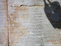
Today’s visitors will inevitably come across many inscriptions when visiting ancient sites or museums. Reading Greek or Latin is not for everybody, and understanding the meaning of the text and context is reserved only for the happy few. The stone or marble support has more often than not suffered from wear and tear, leaving the untrained eye to merely guess its value. 

We are lucky to find an explanation next to the inscription, rarely a full translation, as those are reserved for scholars. Well, the text may be boring, but it also may contain some exciting twists and turns. Yet, who wants to know? 

In antiquity, people would read the latest laws and decrees, regulations and agreements, peace treaties, manumission of slaves, grave markers, boundary stones, milestones, etc., as they walked through public spaces. Some of these texts are still in situ, particularly those engraved on the walls of still-standing monuments. The majority, however, has found a place in the museum for safekeeping and is often out of sight. 

The most familiar examples of inscriptions are those chiseled on grave steles, sarcophagi, and tombs. They also appear on the pedestals of statues lining the streets like Phaselis Harbor Street or Olympia’s road to the Stadium. Others serve to identify the deities, kings, and emperors that fill the sanctuaries and agoras, or the niches of theatres, stadiums, libraries, baths, Nymphaeums, and other public buildings. 

But some inscriptions will surprise many of us. 

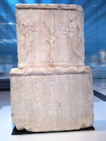
For instance, this stele at the Louvre Museum holds the accounts of the Parthenon Treasury. The text covers both sides of the stele made of Pentelikon marble and illustrates how democracy works. Athens magistrates submitted the public accounts to the citizens for all to see. The front side, beneath a relief of the Sacred Olive Tree flanked by Athena and the people (demos), displays the expenses for military operations, religious ceremonies, and the Panathenaic festival held in honor of their patron goddess for 410-409 BC. The reverse side has the expenditures for 407-406 BC.

In Butrint, Albania, a striking series of inscriptions is carved on the outside walls of the Roman Theater of Buthrotum, as the city was called in antiquity. 
They are hard to read but worth our attention because these are manumissions, slaves who had gained their freedom for whatever reason. Their sheer number is mind-blowing!


As surprising and revealing are the Edicts on prices! Who would have thought that there were strict rules to define the prices of goods in antiquity! 
The first such example I encountered was at Ptolemais in Libya, proclaimed by Emperor Diocletian in 301 AD.

Also by Diocletian is the Edict on maximum prices for products and labor discovered in Halicarnassus, dated to 301 AD. The Emperor hoped to stave off a financial crisis and prevent inflation. 

Although this tablet was unearthed in Bodrum (the modern name for Halicarnassus), bits of similar Edicts were also found in Pergamon, Aizanoi, Aphrodisias, and Stratonikea. It is quite surprising to read that the Edict from Halicarnassus consists of 37 parts. Part 9, for instance, is about shoes and boots … 27 different kinds and sizes are listed!

Taxes are another matter that deserves attention. One such inscription that is hard to miss can be seen on Curetes Street in Ephesos, close to the Library. 
This tax law was written in the second half of the 4th century AD, during the rule of Emperors Valentian I, Valensand Gratian.

Less obvious is Alexander’s tax remission from the wall of the Temple of Athena in Priene, now exhibited in the British Museum in London
Alexander contributed to the cost of building the unfinished temple, and in return, he was allowed to dedicate it: “King Alexander dedicated the temple of Athena Polias”. 
This text was followed by a longer inscription setting out the terms of an agreement between Alexander and Priene under which the city was to be exempt from taxation. 

Not all inscriptions were written in Greek or Latin, and I find it fascinating to hunt for these exceptions. 

Having a closer look at Lycia’s sarcophagi strewn throughout the landscape, I discovered texts that seemed to be written in Greek but are in Lycian, as they contain several odd letters that do not exist in the Greek alphabet. Antiphellos and Limyra have good illustrations of Lycian texts.

Another case is to be found in Sillyum some 25 kilometers northeast of Antalya, an often overlooked site although the hillside is easily spotted in the otherwise flat plain of Pamphylia. 
It takes some detective work to locate the inscription in the Pamphylian language carved in the doorpost of a Hellenistic building – a very rewarding effort though!

The people of ancient Side also had a language of their own. A small inscription has survived and can be seen at the local museum located inside the remains of the Roman Baths.


After Alexander conquered Lycia and Pamphylia, Greek became the lingua franca, and the local tongues disappeared.

Sunday, August 23, 2020

Greek, or not so Greek

Inscriptions in Greek are just one of many. For the layman, they are nice to see, but they add nothing to the beauty or to the specific style of a monument. The mind casually registers the Greek letters. Deciphering those ancient texts must be an exciting occupation but unfortunately limited to a select group of scholars.

Ereichteion building accounts in Greek
For obvious reasons, Greek is the vehicular language in ancient Greece and also in Ionia, the Greek colonies on the coast of Asia Minor. Once further inland and eastward, Greek becomes the lingua franca with the rise of Hellenism. We have to thank Alexander the Great for spreading the language is his wake. 

In antiquity, temple walls held the latest decrees, the agoras displayed the edict on prices, and the base of statues or tombstones left us the name of the owner. Whenever of particular interest, these Greek slabs have been removed from their location and ended up inside a museum. Often, they reside entirely out of context in a dark storage room. From time to time, a rare example is dusted off to be seen by the museum visitor. If we are lucky, their label provides us with useful information otherwise totally lost.

Those occasional displays remain problematic as I discovered recently at the Louvre in Paris. Here, a particular gallery exhibits about a dozen engraved slabs. However, unless you are a scholar or a historian thoroughly familiar with the history of the finding place, it remains impossible to appreciate their value or significance. 

Lycian inscription from Xanthos

Luckily there are interesting details that even an untrained eye can easily spot. One striking example is the Lycian language. At first sight, the letters are Greek, but on closer look, they are mixed with several un-Greek signs. The profusion of sarcophagi that are strewn all over the Lycian landscape is a valuable source of information that provides many such texts we can readily recognize. 

Pamphylian language from Sillyum
Another oddity is the Pamphylian language that was different from Greek but used the same letters. An example is, for instance, left in situ on the doorjamb of an ancient building in Sillyum. It is not easy to find but makes a fascinating reading experience, especially since it is in its proper place and keeps its full meaning.

Entirely foreign, however, are the letters used in the language of the people in Side. One such a rare transcript is displayed at the Museum of Side and worth to be noticed. I can’t help wondering how it would sound and if a Greek visitor was able to converse with a Sidian.

Sidian text
Of course, each region had (and still has) its own dialect that generally was not too foreign to Greek speakers. Macedonian, as a matter of fact, was considered as “a kind of Greek” but the texts were written in Greek – even if this was not exactly Attic Greek.

I agree that the subject of written language definitely is beyond my comfort zone but lifting a tiny corner of deciphering ancient writing is by itself very worthwhile. Even if it opens only a small window into this vast world.

Friday, October 25, 2019

Alexandria on the Oxus is at Kampyr Tepe

As mentioned earlier in my blog About Alexandria on the Oxus, the Russian archaeologist Edvard Rtveladze has been digging at Kampyr-Tepe since 2015, a strategic location even today as it is situated on the border between Afghanistan and Uzbekistan.


So far, it had been established that Kampyr-Tepe was a Graeco-Macedonian fortress raising the question of whether it had been founded by Alexander the Great and if this was his Alexandria on the Oxus or Alexandria Oxiana. Until now, that Alexandria was thought to be located at the confluence of the Kokcha River and the Oxus River, i.e., at Ai-Khanoum in Afghanistan

Patience and determination certainly paid off for Rtveladze, for after finding a sanctuary, a treasury, and a harbor with distinct Hellenistic characteristics, he finally unearthed the main gate this year. It is said to be identical to that of Sillyum in Pamphylia. If so, we can match it to the gates of Perge and Termessos in Turkey and that of Apamea in Syria as well. They all share this typical semi-oval shape on the inner side of the gate. To find that same pattern this far east can only have happened in the wake of Alexander. What a revelation!

Thanks to the discovery of a new coin depicting Apollo and analysis of other layers of Kampyr-Tepe, the foundation of Alexandria on the Oxus could be dated to the 320s BC, which matches Alexander’s campaign in Central Asia perfectly. This was not the case for Ai-Khanoum.

Later this autumn, Edvard Rtveladze will return to Kampyr-Tepe to further investigate the main gate. Besides the citadel and the upper city that were revealed earlier (see: About Alexandria on the Oxus), the main temple dedicated to Demeter has been located, as well as the river crossing.

Unfortunately, there is no picture available on the gate at Kampyr-Tepe yet.

Friday, May 1, 2015

Ptolemais, heritage of the Ptolemies in the Cyrenaica (eastern Libya)

The origin of Ptolemais (or Barca) of the Libyan Pentapolis (see: Apollonia in Cyrenaica (eastern Libya) after Alexander) goes back to the middle of the 6th century BC. Still, the name Ptolemais was probably given by Ptolemy III Euergetes, the grandson of Ptolemy I, who, in 322 BC, added the city to his realm after becoming the ruler of Egypt as successor to Alexander the Great. When the Romans annexed Egypt in the first century BC, they granted Ptolemais the status of a separate province. Since the city had no local water supply, the Roman architects managed to bring in water from the surrounding hills and store it in seventeen huge cisterns under the Forum. It was a flourishing city until it was hit by the destructive earthquake of 365 AD that caused the entire North African coast to drop about four meters. The invasion of the Vandals in 428 probably gave the final blow. The Byzantines moved their military governor to Apollonia, and the Arabs ensured the city was abandoned.

It still looks abandoned today, a mere flat site thrown with stones and rocks with a sporadic tree to bring in some color. The access road to ancient Ptolemais is not inviting either, as it runs through a solid row of abandoned houses that the Italians built last century – a proper ghost town known as Tolmeitha. It is an eerie feeling to progress over this straight road flanked by colorful facades with cast iron decorations, which for some reason, made me think of the Via Appia in Rome, where the tombs are replaced by empty houses.

The city of Ptolemais is no more than a field on a gentle slope from the Mediterranean up to the mountains, where even the Hippodamian plan is hard to figure out. I am happy to be pointed to the familiar Decumanus and Cardo once I’ve reached the crossroad where a piece of wall and a lonely column are all that remains of the Arch of Constantine from 312 AD. The Decumanus has been promoted to Monument Street or Via Porticata, with on one side the Roman Baths and on the other the remains of a private house. It was on this road that the Edict of Diocletian from 301 was found setting the prices for the trade goods now in the local museum.

At the next crossroad, marked with Four Columns, I turn right to visit the imposing remains of the so-called Palazzo delle Colonne, meaning the “Villa with the Columns.” Since this is about the only reconstructed building, it can hardly be missed. The Villa lies here in all its splendor, and it is generally accepted that it was built according to the then-prevailing fashion in Alexandria (Egypt). This theory is hard to verify since old Alexandria is still buried deep under the modern city, and an excellent example of such a villa has never been found, but I like the idea. In any case, the owner was not a poor man.

We owe the qualification of Palazzo to the Italian archaeologists of last century who found that it covered an entire street block (600m2) and counted two levels. The rear of the building, in fact, the living quarters, is resting on a plateau from where the owner had a panoramic view over the city, and I can see all the way to the seafront. This part had an upper level, probably the sleeping quarters. In front of these quarters below me, there is space for eight shops opening into the street with, in the back, their own storage rooms. This storage lies next to a large patio and a complete bathing complex, including a Caldarium, Tepidarium, and Frigidarium, probably for the master of the house and his family. A separate staircase leads from the house directly to the patio below.

The re-erected columns are not well restored, with big blobs of cement in between, but they give an excellent idea of the past glory. The leaves at the bottom of the columns are quite exceptional, a subtle hint to Egypt – hence the name oecus aegyptius used to name this room. It takes some imagination to crown these columns with the capitals (now at the local museum) of the Corinthian order, with Jupiter and Mars' heads staring down from between the acanthus leaves.

Behind this room and in the center of this complex lies the Atrium, including the earthen pipes that led the water to the bubbling fountain in the center of the pool. The Atrium was surrounded by a covered gallery resting on Ionic columns and paved with black and white mosaics, now carefully covered with plastic and soil. However, the edges are still exposed here and there. Central in this Atrium is the summer dining room that offers a view over the inside garden, and the water basin once paved with magnificent mosaics. More protected from the elements lies, on the right-hand side, the winter dining room adjacent to the so-called Medusa room after the mosaic found here, which has also been moved to the museum.


I am quite impressed by this Palazzo delle Colonne, not only because of its location, which is striking by itself, but also by the entire combination of these unique columns with their decoration and paintings, the many mosaic floors in color as well as black and white, and the many statues that enhanced these rooms because the Venus and Bacchus from the museum certainly were not the only ones found here. This Villa, in my opinion, goes beyond what has been found in Pompeii or Herculaneum, although they have other characteristics.

The next house block is entirely occupied by the Forum, paved with small slabs of marble and surrounded by columns, a few of which have (not too well) been restored. Under this Forum from the second century AD (in Greek times, this was a Gymnasium), the true treasure of Ptolemais lies buried: its water cisterns. Eight such huge galleries run north-south over a total length of 50 meters, and nine run east-west over 20 meters. I have seen such cisterns in cities like Termessos and Sillyum in Turkey, but not of this size. The oldest cisterns are from Hellenistic times, and when I climb down the stairs in the center of the Forum, I can clearly see the marks where supporting beams held the flat wooden roof of that period. The Romans later covered the entire system with vaulted ceilings and, in the process, more than doubled the storage capacity to reach as much as six million liters! It is a unique experience to walk through these vaulted galleries!

Right behind the Forum lies the Odeon – a somewhat controversial building. Originally built as a Bouleuterion, this Odeon dates from the 4th-5th century but might as well be a small theatre since the half-circular orchestra could be filled with water. However, the water supply is too far away from the theatre to be used as such, and even if this space could be filled with water, to what purpose was it used? Some archaeologists opt for miniature sea battles, while others think the water would be used to improve the acoustics. For the time being, this remains a mystery.

At the far end to the left, on the west side, one can discern the contours of the Teucheira city gate from the 5th century AD, but the entire extent in between seems still in dire need of excavations. Ptolemais definitely was an important city.

On my way back, walking over the westerly Cardo to the exit, I stopped at the Roman Villa where the mosaic of the Four Seasons was found (now at the local museum). Not much to see except that this building deserves to be called a villa. Noteworthy is that the colonnade around the Atrium ends in a horseshoed shape – an exception to the standard square pattern. Simple smooth columns surround the central area, neatly restored without the blobs of cement the Italians used elsewhere.

The local museum is nothing more than a large storage room, but it is nice to have it so close to the place of excavation (Now, a few years after the fall of Kaddafi, I wonder what has become of this place). I marvel at the fine mosaics apparently imported from Alexandria framed by rougher mosaics laid by local craftsmen. The Medusa-mosaic from the Palazzo delle Colonne steals the show, next to two fragments with hens and fishes and another large mosaic carpet showing the Four Seasons with two panthers underneath. True jewels!

Next to a beheaded Bacchus and an elegant Venus with the head of Demeter (a strange combination), both from the second century AD and found at the abovementioned Villa, there are several painted and artistically carved Corinthian capitals revealing the heads of Jupiter and Mars. Interesting also are the aerial views of the villas I just visited. In a corner, I find the remains of a sarcophagus with an image of Achilles and, standing behind him, his mother, Thetis. An intriguing discovery, although I need help understanding what they are doing here.

One of the masterpieces is the slightly damaged panel from the Via Porticata, which shows several goods and their respective prices according to the Edict of Diocletian from 301 AD. That such legislation existed at all is quite impressive! Next to it stands a particularly graceful relief with six dancing Maenads found on the same avenue. The Maenads were a favorite subject in antiquity, and this relief has enhanced the base supporting a statue of the dramatist Euripides. The original statue was sculpted in Athens in 405 BC, but this is the best (Roman) copy. The ecstatic Maenads, followers of Dionysus, are particularly elegant in their floating robes, waving the thyrsus staff and shaking their tambourines. Such a pity that in later years, the piece was used around a well, for otherwise, it is relatively well-preserved.

Once more, this is a city that owes its glory to Alexander the Great and his successors as it lived on for another 700 years. Ptolemais definitely deserves to be added to the list of Alexander’s achievements.

If we pay more attention than usual, we find much more than the sites and buildings we are pointed towards. It happened to me when we drove out of Ptolemais, and I noticed the remains of a Hellenistic tomb, clearly inspired by the Mausoleum of Halicarnassus. It is no more than a lonely square in the middle of an abandoned field used as a garbage depot, although fenced off with barbed wire, planks, and corrugated roofing. The original tomb must have been much higher than the remaining 11 meters, but the floor plan of 12x12 meters is still intact. This tomb belongs to the second century BC, Ptolemaic times, and still carries the alternating motives of triglyphs and metopes along the top edge, although the friezes have since long disappeared just like the steps at the base. As elsewhere, it was common practice to dismantle old buildings to reuse the recuperated stone blocks in new constructions (spolia).

Monday, August 5, 2013

Sillyum escaped to Alexander’s siege

Even in today’s landscape the trapezoidal hill of Sillyon is clearly visible in the overall flat plain of Pamphylia. I even could see it from the plane one day while taking off from Antalya airport, but of course you need to know what to look for. Driving toward Sillyon or Sillyum as it was called in antiquity, is not difficult – just take any road in the general direction, you can’t miss it.

It does not take a specialist to realize that because of its location alone, Sillyum is an impregnable fortress. The Persians had a mixed force of foreign mercenaries and native barbarians there and it was the first Pamphylian city to resists Alexander. As can be expected, the king didn’t hesitate to attack, but was not very successful. However, before he could conceive a second plan, the news reached him that the people of Aspendos had changed their mind and decided not to respect the freshly signed treaty. Catapults were immediately dismantled, the arsenal wrapped up and Alexander’s troops were summoned to march back to Aspendos. Since Sillyum had no access to the sea like Perge or Aspendos, Alexander decided that Sillyum was not worth the trouble of a siege and fell back on Perge.

The origins of Sillyum are shrouded in the mist of times, probably going back as far as the Trojan War. Very few excavations have been carried out and present conclusions are based solely on visual assessments. Sillyum’s heydays seem to have been lived during the 1st century BC when the road from Perge to Aspendos led through Sillyum as is obvious from the Peutinger roadmap (i.e. a medieval map copied from a Roman original of the fourth century). The tombs outside the city date mainly from between the 3rd and the 6th century, which makes sense when you consider that the most recent building on this hilltop is from the Byzantine era.

The remains we see today are mainly Roman but several Hellenistic features can still be found, like for instance the horseshoe-shaped court with a tower on each side built according to the same Hellenistic design as the one in Perge, and still pretty much recognizable. There are also two Hellenistic buildings, including the building in which an inscription in Pamphylian dialect still enhances the doorpost, and the meagre remains of a crumbling theatre.

I start my climb of a good 200 meters over a narrow path through the thickets on the west side, the only side that is not absolutely vertical. I’m happy to reach my first clue: a square tower that originally was part of the lower city fortification built when the people of Sillyum moved to lower grounds in order to be closer to their fields. Originally it was two stories high and curiously enough the door on the north side has a horizontal lintel while the inner door is arched.

When I reach the broad slope towards the old Roman city gate I can get my bearings. I find part of the ancient ramp – always an exciting element in any site. From here I literally have to dive into the shrubbery through a low doorway leading to a dark space. Once my eyes are accustomed to the dim light I see four cows that found refuge in this cool room to ruminate. I’m not too happy with this crowded reception and just hope I won’t step into any cow dung. All goes well and I’m glad to be back in broad daylight again. I’m now walking through the Roman Baths with rounded walls that held the vaulted ceilings and I even recognize the square windows of the solarium.

Slightly lower there is a small fountain still pouring out cool spring water for the thirsty traveller on a hot summery day. In the grass a fallen base proudly shows its Greek inscription – well, I suppose it is Greek for at least the letters are Greek. It may well be an inscription in Pamphylian for I have read in George Bean’s book “Turkey’s Southern Shore” that there must be some rare Pamphylian writing around here. I have no way to figure this out.

It is only when I find the inscription in the doorway that matches the photograph in George Bean’s book that I know that I am looking at something Pamphylian, a local dialect related to Greek and quite different from the language written and spoken in Side. Although this inscription uses Greek letters and runs over 37 lines it is not being understood, except for a few loose words, like the name Selyviios. By the year 100 BC the Pamphylian language has completely disappeared to be replaced by Greek that is by then generally spoken in the area. In any case, I feel privileged to have seen this inscription with my own eyes. Said doorway is part of a Hellenistic building with richly decorated frames around the windows and doors, probably dating from around 200 BC. The bushes are much too dense to make any sense of this construction or even to take a decent look at it from a distance.


Another yet larger Byzantine building stands next to it with its impressive 55 meters-long western wall, reaching a height of six meters. It counts ten windows, strangely enough all of different sizes.

There are plenty of trails and tracks crossing each other and I wonder if they are created by cows and goats or by the sporadic visitor like me. I tread with care through the high grasses and low shrubs for I have now reached the “Hall of Many Cisterns”, an area cramped with pits of ancient wells. One misstep could mean a broken leg – no thank you. The marble holes still show the deep grooves from the many ropes that ran through them over the years. There is even a huge underground cistern nearly thirty meters long, of which I see the entrance but dare not enter. 

Unexpectedly I arrive at the edge of the high plateau. It looks as if there are only a few blocks lined up there and it occurs to me that it might be a wall of some kind, but when I get closer I discover them to be the upper seats of the theatre. A landslide in the spring of 1969 took most of the theatre away including its stage and the Odeon next to it. All that remains are these four rows of seats. Such a pity when a theatre survives for so many centuries to disappear 2000 years later because of a landslide. The view however is breathtaking for I have an all embracing picture of the wide landscape all the way to the sea – roughly ten kilometres to the south.

I return along the Hellenistic Gate with its round towers as I have seen in Perge and Side, once part of the fortification built by the people of Sillyum when they moved their houses closer to their fields. For me this is one of the highlights of the day since it is bringing me closer to Alexander.

[Click here to see all the pictures of Sillyum]

Monday, July 15, 2013

Aspendos, the unfaithful

It seems that the people of Aspendos were not too happy with their Persian ruler, for when in 333 BC, they heard that Alexander the Great was on his way, they set out to greet him and surrendered their city on the sole condition that Alexander would not leave a Macedonian garrison behind. Alexander agreed but demanded payment of fifty talents and the same number of horses as they usually delivered to the Persian King.


Once this agreement was reached, Alexander moved onward to Side and from there westwards to Sillyum, which resisted. While he was in full siege, he was informed that Aspendos had no intention at all to keep their promises. They had called their citizens inside the city walls, and the gates were slammed in the face of Alexander’s ambassadors. The city was bracing itself for an attack. They evidently underestimated Alexander and never expected him to show up in person or so quickly – most probably in a great state.

Entirely surprised and totally bewildered by their opponent’s quick action, Aspendos was forced to ratify the previously made agreement and promised solemnly to pay the fifty talents they agreed on before. Alexander was smart enough to accept this gesture of goodwill because the city was a strongly defended fortress that could withstand a lengthy siege. But he claimed an extra fifty talents, hostages from prominent families, and the payment of a yearly contribution to Macedonia. No kidding!

The oldest name for Aspendos is Estwediiys, a city probably founded by Mopsus around 1200 BC. As early as the fifth century BC, the city minted its own silver coins – with Side the only one in Pamphylia to do so. In the days of Alexander, Aspendos was flourishing and was best known for its horses. The Persians had the exclusive rights to these noble animals, but now it was Alexander’s turn to claim that contribution and four thousand horses were promptly delivered to his army – quite a stock, I would say.

After Alexander’s death, Aspendos was taken in turn by the Seleucids and the Egyptian Ptolemies, and in the 3rd century AD, it became the third city of Pamphylia. Under the Roman Emperors, it was an important trade center for salt that was collected from the nearby Lake Capria, which according to Strabo, dried up in summer, enabling an easy harvest. The commerce of wine and horses also flourished till the city finally shared the same ill fate as its neighbors. The Byzantine Emperors organized and reorganized Asia Minor time and again, joining Lycia to Pamphylia and separating it again in the end, allowing each to be an independent province. Later we find the Arabs’ and the Crusaders’ conquests till the area was absorbed by the Ottoman Empire.

Nothing much is left to see of the old harbor of Aspendos. There is the Seljuk bridge over the Eurymedon River (now Köprü River) which is said to rest on old Roman foundations. You have to be very alert after leaving the D400 towards Aspendos to notice this bridge on your right, but if you can make a halt there, it is definitely worth the visit. The bridge, restored as recently as 1996-1998, is about 225 meters long and reaches the opposite bank after a slight bend. Somehow it reminds me of the famous bridge in Mostar, the same vault construction, but here it is repeated seven times. It is the achievement of the Seljuk Emperor Aladdin Keybatt (1219-1236), who saw the true value of this (re-)construction. You’ll easily find the Roman base in the fast-flowing water. It is as easy to imagine how in antiquity, ships passed under this bridge (which was higher in those days) to deliver their goods in Aspendos before the harbor silted up.

The absolute highlight of Aspendos is, of course, the theater, one of the best preserved in the world. Like most of the buildings, it dates from the 2nd century AD, probably built during the rule of Marcus Aurelius. According to the inscriptions, the side entrances were mandated to architect Zenon by two brothers, Curtius Crispinus and Curtius Auspicatus. Officially the theater offers seating for at least 20,000 visitors, but rumors have it that, at times, twice as many were crowded inside! It is quite unique to see the well-preserved stage wall, which somehow may remind the visitor of the Theatre of Herodus Atticus in Athens, but this one is in much better condition. I walk the entire width of the podium, which originally was much wider because it had a wooden extension, staring up at all the decorations, garlands, and figures around the niches framed with slender columns and which once held statues of important citizens. Under the baldachins of what could be the second level, I discover a series of lovely faces, all different in expression and appearance. It’s like the past staring back at me. In the middle of this back wall, a relief of Dionysus fills the triangle of a pediment. On a previous visit, the entire stage was hidden because the theatre was still used for performances, now luckily forbidden. So these details are quite a revelation!

This theater is definitely Roman, a perfect half-circle with a wide gutter at the feet of the lowest row of seats that could be filled with water to enhance the acoustics. I wonder about the need for increased acoustic effect, for I’m deafened by the cacophony of people of all nationalities and several busloads of children from local schools. I climb the stairs to the diazoma, the walkway separating the lower and upper part of the theater and from here the staircases are doubled. It’s lovely to visit the connecting corridors in the back, which only served to support the construction and had no specific function – still in such good condition. Back in the blazing sunlight, I have an entirely different look at the stage wall as some of the features are now at eye level. I can clearly see the holes that once served to hold the wooden beams for the roof, which covered the stage only and were meant to enhance the acoustics –so clever. Higher up are other holes that could hold the wooden poles used to fix the awning, which protected the theater-goers from rain and sun. How dare we think that we invented the notion of comfort! Another exceptional feature is the stylish porticus that crowns the upper rows behind the very last seats, which usually doesn’t survive in these ancient theaters. I walk underneath arches in near-perfect condition along a closed wall to the outside, while on the inside, the walkway opens into the theater. Marble blocks and columns frame the separation between one arch and the next. About three of such arches have been carefully restored and blend in entirely with the surviving parts. It does not take a lot of imagination to taste the atmosphere that must have reigned here with so many Roman sandals scraping the pavement.

I also venture inside one of the corner towers that frame the podium. The basement was generally used as a foyer for the audience, but the meaning of the staircase above it is not known. This is, however, a magnificent example of how the Romans built their staircases. In the very center of this tower, a square pillar was constructed, and all they had to do was to fit a large slab of stone, one for each step, resting on the outside wall and on the central column. It is so simple, yet you have to come up with the idea, of course. The outside walls of the right-hand tower still hold traces of painted plaster of white and red lozenges, I suppose from Byzantine times or maybe even from the Middle Ages. Anyway, a clear sign that the theater was used for a pretty long time.

Next to these towers, above an arched entrance, I find a “royal loge.” I wonder about the exclusivity of this seating because it only offers a sideways view of the stage.

All in all, this is a magnificent construction used till recently when summer opera festivals or performances of The Fire of Anatolia were performed here – now moved to a new theater in Roman style built outside the town. A good alternative to spare this unique antique site.

For most visitors, this is where their visit ends, but I venture into the antique city over a path that starts between the theater and the toilets. I walk over a paved road near one of the city gates where the city’s sewage is covered with broad flat slabs. Occasionally one such slab is missing, but that makes it even more exciting because spots like these offer an inside view. I estimate the cavity at about 1x1 meter - a sewage system that will not easily clog up!

On the left, I feel the shade of the large Basilica, the center of commerce that originally was more than 90 meters long. Only the walls’ fundaments have been preserved, but they allow a good estimate of the dimensions. The part I see from my path is only an annex but definitely a sturdy one with walls 15 meters high and almost two meters thick. Next stands an Odeon, that is according to my map, but because of the high overgrowth I cannot see it – such a shame, but inevitable I suppose. On the other hand, I can access the 15-meter-high Nymphaeum in front, but it has lost most of its decorations, and it takes quite a fertile imagination to picture this fountain in full glory. For those who have seen the Nymphaeums of Side, Perge, or Sagalassos, mental reconstruction is much easier. It now appears as a mere wall, although 37 meters long and 1,8 meters thick – not bad. The Basilica wall runs at the right angle with this Nymphaeum, and in between, we should picture the Agora, now entirely overgrown also. The two-storied shops on the opposite side of the Agora are, however, clearly visible.

After the Agora, I can stare into the depths towards the gate through which Alexander entered the city. I scramble down, and to my great surprise, I discover that this gate also was round, exactly what I had seen in Perge and in Sillyum. I probably read that somewhere, of course, but seeing it with my own eyes is another ballgame altogether. Inside the curves, I can still see the niches that once must have held important statues – quite plushy in those days. There are more remains of the Roman city wall between the trees further down the slope. The archaeologists still have work to do if they want to.

I get back to the top of the plateau and walk to the edge to admire the other attraction of Aspendos, its famous aqueduct that spans the entire once swampy valley. This is an ideal spot for a good overview of the entire project, but of course, I’ll visit the remains afterward.

Returning to my steps, I encounter a panel pointing to a “temple hill.” I have no idea what this means and decide to follow the general direction. At the top of the low hill, I do indeed find remains that seem to refer to a temple, but these are mere foundations. Yet the view from here, now on the other side of the high plateau, is worth the detour. The Basilica behind me commands the picture like a medieval fortress in front of which I can now clearly see the Odeon. Higher up lies the Nymphaeum I passed earlier, with the shops belonging to the Agora to its right. Behind me, way down in the valley, I discover the outlines of the Stadium, and I decide to explore it. Without this eagle’s view, I would never have found the vaults that carried the seating area among the exuberant blossoming trees and luscious bushes. The east side seems to be the best-preserved part, but it is hard to get proper bearings, although I am sure this Stadium can’t beat the one of Perge.

Time to turn my attention to the Aqueduct, a masterpiece of Roman architecture that can only compete with the Pont du Gard in France and the Aqueduct of Volubilis in Morocco, however much less dramatic. According to an inscription from the second century AD, a certain Tiberius Claudius Italicus presented it to Aspendos for the astronomic amount of two million denarii! Expensive water …

The water had to come from the other side of the valley, and the aqueduct is a most impressive work of art and still a most impressive ruin in the landscape. The inverted siphon of this aqueduct was 1670 meters long and carried the water from two different springs at respectively 400m and 550m height all the way across the valley to the acropolis of Aspendos situated at an altitude of 60 meters. This inverted siphon is unique because of its excellent state of preservation using three “venter bridges.” For the technical explanation of these bridges, I quote Wikipedia: “Where particularly deep or lengthy depressions had to be crossed, inverted siphons could be used instead; here, the conduit terminated in a header tank which fed the water into pipes. These crossed the valley at lower level, supported by a low "venter" bridge, rose to a receiving tank at a slightly lower elevation and discharged into another conduit; the overall gradient was maintained. Siphon pipes were usually made of soldered lead, sometimes reinforced by concrete encasements or stone sleeves. Less often, the pipes themselves were stone or ceramic, jointed as male-female and sealed with lead.” In the case of Aspendos, the pipes consisted of 3400 blocks of limestone that were sealed together with a mixture of lime and olive oil that expanded when wet. There are still plenty of these pipes lying around at the feet of the aqueduct, enough to kindle your imagination. At each end of the valley, we still can see the thirty-meter-high tower (without roof) in which the water would settle down and re-oxygenate itself before flowing onward. Today a motor road runs underneath each tower, making a close look very tempting and highly rewarding. 


By the time I wrap up my inspection tour, the sun is setting. The entire valley is set afire with this natural floodlight, and I feel privileged as if the performance is for me alone. I’m certain the Romans would never understand my exaltation for these two thousand years-old ruins!