Alexandria's founded by Alexander

Alexandria's founded by Alexander the Great (by year BC): 334 Alexandria in Troia (Turkey) - 333 Alexandria at Issus/Alexandrette (Iskenderun, Turkey) - 332 Alexandria of Caria/by the Latmos (Alinda, Turkey) - 331 Alexandria Mygdoniae - 331 Alexandria (Egypt) - 330 Alexandria Ariana (Herat, Afghanistan) - 330 Alexandria of the Prophthasia/in Dragiana/Phrada (Farah, Afghanistan) - 330 Alexandria in Arachosia (Kandahar, Afghanistan) - 330 Alexandria in the Caucasus (Begram, Afghanistan) - 329 Alexandria of the Paropanisades (Ghazni, Afghanistan) - 329 Alexandria Eschate or Ultima (Khodjend, Tajikistan) - 329 Alexandria on the Oxus (Termez, Afghanistan) - 328 Alexandria in Margiana (Merv, Turkmenistan) - 326 Alexandria Nicaea (on the Hydaspes, India) - 326 Alexandria Bucephala (on the Hydaspes, India) - 325 Alexandria Sogdia - 325 Alexandria Oreitide - 325 Alexandria in Opiene / Alexandria on the Indus (confluence of Indus & Acesines, India) - 325 Alexandria Rambacia (Bela, Pakistan) - 325 Alexandria Xylinepolis (Patala, India) - 325 Alexandria in Carminia (Gulashkird, Iran) - 324 Alexandria-on-the-Tigris/Antiochia-in-Susiana/Charax (Spasinou Charax on the Tigris, Iraq) - ?Alexandria of Carmahle? (Kahnu)
Showing posts with label Philip-V. Show all posts

Thursday, April 11, 2024

The short-lived appearance of King Langaros

Alexander’s campaign into the Balkans before marching east to conquer the Persian Empire is often neglected and even forgotten in literature. 

Only occasionally do we find a name. This is the case for Langaros, King of the Agrianes, who had openly chosen to side with Alexander as he had done with Philip before him. 

When Alexander made his way to Pelium in 335 BC, he faced a threatening revolt of the Illyrians led by Cleitus, king of the Dardanians. Cleitus had persuaded the Autariatae and the Taulantians to join forces (see: Alexander's psychological warfare in Pelium, Illyria). The situation looked bleak for Alexander, who needed to know more about the strength of these Autariatae. 

Langaros, faithful to Alexander, attended him with his bodyguard, the finest and best-equipped troops, and told his friend that he would take care of this warlike tribe. He actually did so, and with Alexander’s consent, he invaded and occupied the Autariatae territory, causing severe losses to their common enemy. 

Alexander showered Langaros with every mark of honor and gifted him with many high-valued presents as proper at the Macedonian court. He also promised Langaros that if he visited him at Pella, he would give him his half-sister Cynane in marriage. Cynane was the daughter of Philip II and his Illyrian wife Audata (see: The many wives of Philip II of Macedonia). It was not to be, as Langaros, after returning home, fell ill and died. 

Our only source for this story is Arrian, who kindly remembered him. 

Recent archaeological digs near the city of Kumanova in North Macedonia have revealed remains of an important yet unknown town from the 4th century BC. Besides a pool with a plastered floor, some plastered walls, capitals and bases of columns, and appliqués have been found. They are consistent with similar details from Aegae and Pella

It is far too early to draw any conclusions right now and to link the ruins to King Langaros’ capital. The pictures of the site are not adding much to the story yet. As we know, excavations in that part of the world are slow to materialize. 

This King Langaros is not to be confounded with the Illyrian King Longarus, who ruled over the Dardanians from 231 to 206 BC. 

Longarus, however, played an important role in the life of Philip V of Macedonia, who regularly attacked the Dardanians. Taking advantage of Philip’s campaign in the Peloponnesus in 219 BC, Longarus occupied Bylazora, the capital of Paeonia. His success was short-lived, though, as two years later, in 217 BC, Philip V captured Bylazora, blocking the Dardanian access road to Macedonia.

Tuesday, April 2, 2024

Bylazora, the last Macedonian Palace

The Paeonians occupied the land north of ancient Macedonia and functioned as a buffer zone with the Dardanians on their northern border. Bylazora, in fact, was situated in a commanding position at the natural pass leading from Dardania into Macedonia. 


Philip V of Macedonia, who ruled from 221 until 179 BC, captured Bylazora in 217 BC. By blocking the Dardanian access road to Macedonia, he freed his country from its repeated menacing raids. PerseusPhilip’s son, who succeeded his father, sent mercenaries to Bylazora to confront the Romans, but he was defeated in 168 BC. He was taken to Rome to be shown in their victory parade, together with the incredible wealth of Macedonia. The rich kingdom became a mere Roman province. 

Although Bylazora was the largest city of Paeonia and was mentioned by Livy and Polybius, its location remained a mystery. It was tentatively identified with (Titov) Veles, but the results were inconclusive. As so often, the city was discovered by accident in 1994. Road works exposed a buried pool-like building close to modern Sveti Nikole in the Republic of North Macedonia, some 50 kilometers southeast of Skopje, between the Axios and the Strymon Rivers. 

Excavations started in 2008 after the Museum of Sveti Nikole invited the Texas Foundation for Archaeological & Historical Research (TFAHR) to a joint cooperation. 


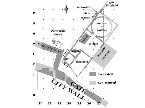
It was a slow process of searching for clues that started at the top of the hill, the Acropolis. Soon, a section of the northern defensive wall was exposed, followed by the discovery of a ramp leading up to the Propylon. Next, a Stoa with Doric columns was identified and dated to the days of Philip V based on a similar gallery built by Attalus II in Athens. 

A long wall and successive rooms were unearthed, making the archaeologists realize they had found the Palace of Philip V and Perseus, the last two kings of Macedonia. 

The first room they explored had all the characteristics of a kitchen, with a fireplace, much pottery, plates, vessels, and amphorae from the 3rd-2nd century BC. The walls were covered with a thick layer of plaster with traces of paint. Followed a room with columns and capitals, which was named Ante-room since it connected to a more important Tholos. For those who visited the Palace of Aegae in Greece, that space is very recognizable. On the other side of this Tholos lies the Entrance Hall, which in turn is connected to the Vestibule. This large room opened onto the Outer Courtyard via a monumental staircase. 

Keeping the layout of the Palace of Aegae in mind, the archaeologists projected the same series of rooms around the Inner Courtyard. The picture seems to fit perfectly. It also matches the Palace of Dimitrias, situated just south of Volos in Greece. The city was built by Demetrios Poliorcetes when he was king of Macedonia, i.e., 294-288 BC. 

Until now, and as opposed to Aegae and Pella, I had no knowledge of the Macedonian Palaces of Bylazora or Dimitrias. The destruction of the Palaces of Aegae and Pella by the Romans is well-documented. Dimitrias, however, was entirely dismantled, and it is assumed that the same happened in Bylazora, although it was never finished. 

Much more pertinent information with clear maps and unique details can be found in this lecture given by Dr.William J. Neidinger of the TFAHR.

[Pictures from TFAHR]

Friday, July 16, 2021

There is more to Aegae than the Royal Palace and the Great Tumulus

Driving from modern Vergina towards the Royal Palace of Aegae, we take little notice of the open fields to our left, where the necropolis of ancient Aegae is waiting to be fully excavated. The very area is uninspiring as it consists of a succession of more or less conic bumps in the landscape. These are, in fact, mounds covering the tombs dating as far back as 1000 BC. The cemetery remained in use until the 2nd century BC. 

Proceeding further south, we encounter the Rhomaios Tomb and the Tomb of Eurydice, Alexander’s grandmother, a few meters onward. Further north lies an undefined Public Building and the so-called Hellenistic House and the Sanctuary of the Mother of the Gods to the west

With its 8.50 meters, the Rhomaios Tomb is one of the longest tombs. It consists of two rooms, an antechamber, and the chamber proper. The antechamber measures 4.50 x 2.50 m and is 2.20 m high. A narrow band runs around the walls and is painted with flowers. The colors alternate on the deep blue background using combinations of red-blue, white-blue, yellow-blue successively, and again red-blue, etc. A marble door separates the antechamber from the main vaulted chamber, which is square (4.50x4.50 m) and 4.45 m high. Here too, a dark blue band decorates the walls, but it is plain blue this time. An impressive marble throne stands in the back of the tomb with a footstand and a kind of bed. The throne is remarkable because of its large size. It is decorated with small painted friezes in the lower part, and its armrests display sculpted sphinxes. 

This tomb has been totally robbed in antiquity, making dating very difficult. However, comparing its features and style to those of the nearby Palace, it has been possible to date it to the first half of the 3rd century BC. Last, but not least, it is essential to note that this tomb was never covered by a tumulus and that its location so close to the village is puzzling.

Hades and Persephone, Vergina
Unknown author, Public domain, via Wikimedia Commons

The Tomb of Eurydice is another large burial monument, which appears to be the earliest known Macedonian tomb. As expected, this gravesite has been plundered in antiquity. However, based on the shards left behind, it could be dated to around 340 BC. The dating, the wealth of the tomb, and the dedications found in the nearby  Temple of Eukleia led us to believe that this grave belonged to Queen Eurydicethe mother of Alexander’s father. The monument is 10.60 m long and nearly 8m wide. It is divided into an antechamber and the chamber proper, which measures 5.50x4.40 m with a 5.80-meter-high vault. The chamber's back wall displays an elegant but straightforward Ionic façade of a Macedonian tomb whose stucco and architectural details have been well-preserved. The trompe-l’oeil painting reveals a central door flanked by two stucco windows separated by two pairs of Ionic half-columns. The frieze of flowers and the cornice of the entablature are painted in vivid blue, red, and green. Like in the Rhomaios Tomb, we find a richly decorated throne two meters high. The back of the seat surprises with a superbly painted panel showing the Underworld, with the gods Pluto and Persephone, standing in full majesty on a quadriga drawn by two white and two brown horses. The throne itself is decorated with reliefs, gilded flowers and animals, and even with statuettes of korai. 

Other remarkable tombs in the area are the Tomb of the Bella Farm (first half of the 3rd century BC) with its delicate facade paintings, the tomb on the Bloukas field (c. 200 BC), and the cist grave of Palatitsa (c. 350 BC) – none of which are open to the public. 

The Temple of Eukleia is situated some 80 meters north of Aegae’s theater and close to the road leading to the Palace. Not much of this sanctuary survived, but it could be established that it had a small pronaos of 4x2.5 m and a square naos of 4x4 m. Archaeologists assume that the pronaos was an open space because the bases for statues were found in the two corners of the naos and possibly flanking a sacrificial table. It is striking that the temple faced north. Along the west side of the temple, three bases for statues were found at regular intervals. On the face of the southernmost base, a valuable inscription was found, reading ΕΥΡΙΔΙΚΑ ΣΙΡΡΑ ΕΥΛΛΕΙΑ, in other words, ”Eurydice, daughter of Sirra (erected this statue) to Eukleia.” The finesse of the letter curving has helped to date the inscription to the second half of the 4th century BC. These elements indicate that Queen Eurydice dedicated her statue to the goddess Eukleia, worshiped in this temple. It is assumed that the other bases carried similar offerings by members of the royal family. 

Roughly 400 meters east of the Temple of Eukleia are the remains of the Sanctuary of the Mother of the Gods. This archaic deity had a close relationship with the cult of Dionysus. By the early 6th century BC, the Mother of the Gods was linked with her Asian counterpart, Cybele. The goddess was worshiped with orgiastic dances and music. On votive reliefs and terracotta statuettes, she is depicted holding a large libation bowl in one hand and a large drum for the orgiastic dances in the other. Her head is crowned with a kind of fortress, referring to her role as goddess of cities and fortification walls.

Together with the information left by ancient writers, the remains of this Sanctuary reveal the importance of the cult. A large square building of 32x32 m has been unearthed in recent years. It contained separate rooms playing an essential role during initiation and worship. Various terracotta figures of the goddess, incense burners, vases, coins, loom weights, and all kinds of architectural relics from the earlier building from the 4th century BC have been found. The excavation showed that this sanctuary, destroyed by a severe fire around 150 BC, dates from Hellenistic times. 

A recent article in the Archaeology News Network mentions new studies of a large building complex close to the northwest gate of Aegae and the “queen’s burial cluster.” However, it is not clear whether this is close to the tombs mentioned above or the sanctuaries, but I suppose it is the case. 

The building complex from the 4th century BC has been associated with the worship of the royal family. It was built with stone from the nearby Mount Vermion and set up in successive square and rectangular rooms reaching 100 square meters. They are organized around a large courtyard. The space on the east side resembles a temple with a very large antechamber and two Doric columns on the courtyard side.

More exciting are the stamps carrying the Macedonian shield, which were also used on the coins by the Macedonian kings in Hellenistic times. Importantly, roof panels bearing the inscriptions AMYNTOΥ. This may refer to King Amyntas III, the husband of Eurydice and grandfather of AlexanderIn any case, it testifies of a close relationship with the Macedonian royal family. Other tiles are imprinted with ΠΕΛΛΗΣ, indicating that this particular sacred building must have belonged to Amyntas, who was given the status of hero. A similar cult is known to have existed in Pydna. Moreover, the presence of Eurydice in her nearby temple cannot be a coincidence. 

Despite the thorough looting by the Roman general Metellus in 148 BC, extensive renovations occurred under Philip V during the late 3rd/early 2nd century BC. For instance, the walls are covered with painted plaster. The favorite color was purple, with touches of green and ochre, and the scenes are divided with reliefs, not unlike those known from  Pompeii. The floors are inlaid with marble, as seen in the Palace of AegaeHowever, it could be established that the cracks and irregularities in the floor levels were due to catastrophic landslides in the 1st century AD. After a period of decline, the city of Aegae disappeared under the debris.

 It is clear that the cult of Alexander was kept alive and that the building complex was a way to confirm and legitimize his power and that of his successors.

Saturday, June 5, 2021

Amphipolis beyond the Kasta Hill

Much ink has been spilled on the promising excavations of Kasta Hill at a short distance from the town of Amphipolis proper. For that reason, the importance of this city harbor has been seriously neglected. 

Amphipolis was an Athenian colony founded in the 5th century BC. It was surrounded by a 7.5-kilometer-long wall, probably dating from the Classical Period, but the date has not been confirmed yet. It would be interesting though, to know whether Philip II had attacked it in 356 BC when he ousted the Athenians in power. Amphipolis was key to the king’s conquest because it sat on the mouth of the Strymon River which gave him access to the mines of Crenides (later renamed Philippi) and opened up the trading route with Thracia (see: Macedonia’s gold and silver mines today). 

[Picture from Structurae.net]

When Alexander set out from Pella towards Asia in 334 BC, he crossed the bridge of Amphipolis (see: Bridge of Amphipolis used by Alexander), which was constructed at some time between 600 and 550 BC and was first mentioned in history during the Peloponnese War of 422 BC. 

The city has a lot to tell us, as the occasional photographic and on-site research reveals. However, the archaeologists seek financial support to establish what Amphipolis looked like in the days of Alexander and how it changed by the time Philip V died here in 179 BC. So far, it has been recorded that the city possessed a well-preserved Gymnasium and the remains of a Hellenistic house with frescoed walls. 

At present, special attention is given to the Acropolis of Amphipolis located within sight of Kasta Hill. Scholars tell us that it becomes easy to understand the city's importance as this location gave its citizens full control over the Strymon River, the gateway to the sea and Crenides, and the overland route into Thracia.

In the past two years, archaeologists have concentrated on the Acropolis, whose inner walls were exposed in the 1960s and 1970s. Otherwise, there is a lot of architectural debris lying around. At the same time, other parts have been reused by the Romans to rebuild the city’s fortifications. The same applied to the Christians when they built their monuments. These public buildings stand on top of older layers, and the current five-year plan (2019-2023) will concentrate on the pre-Christian Acropolis. 

[Picture from Archaeology News Network. Aerial view of the Basilica C with the Hellenistic building below it. [Credit: Kathimerini]

The bottom line is that we still need more patience before establishing a solid link with Alexander in the early days of his kingship.

Sunday, May 16, 2021

Excavations in the Peraia of Samothrace

Except for the greater Athens area, Greece is generally very much underrated when we consider its wealth of archaeological sites. Most people and tourists limit their visit to Attica, extending it possibly to Delphi and the Monasteries of the Meteors to the north and a few antique cities in the northern Peloponnesus. Since the discovery of  King Philip’s tomb in Vergina (ancient Aegae) and the rekindled interest in Alexander the Great in his hometown of Pella, Thessaloniki has become another hub of interest. Otherwise, much of mainland Greece remains to be explored. 

[Picture Credit Peraiao of Samothrace Project from Archaeology News Network]

One such ignored region is the Peraia of Samothrace, i.e., a series of colonies founded by Samothrace along the coastline of Greece’s province of Thracia north of the island. In an earlier blog (see: What is the Peraia of Samothrace?) I mentioned the major settlements by name: Cape Serreion, Drys, Sale, Zone, Mesembria, and Makri, which were founded from the 6th century BC onward. The towns of Tempira and Charakoma, on the other hand, date from Roman times. 

At present, a project has been started to examine the topography of the Peraia of Samothrace and to survey sites located further inland. Most of them have been excluded from archaeological excavations that were only concentrated on the cities of Maroneia and Zone, but Drys and Sale clearly deserve special attention since they were the most important and longest-lived settlements. 

The first surveys were started in October 2020 but were soon interrupted because of the pandemic. The project will continue in 2021 focusing on archaeological research proper, geophysical survey, and remote sensing. Complementary work will include the study of ancient sources, historical maps, and whatever literature is available. Small artifacts in stone, bits of ceramics, shells, and blades have been collected so far and provide clues as to the sites to dig. Most of the fieldwork is expected to be completed this year but the parties involved are facing a huge task. 

The Peraia of Samothrace was of strategic interest in particular for the hinterland of Thracia, which by itself is worth exploring as well (see: Thracian Tombs at Doxipara, Greece). Today the province of Thracia is part of eastern Greece - a country repeatedly conquered by Macedonian kings from Philip II to Philip V and later on by the Romans (see: A solid gold bust of Septimius Severus). The rich civilizations that once thrived here (including the Ottomans in more recent times) deserve to be studied very closely. 

The progress of the planned survey is updated regularly and can be followed on www.peraiasamothraceproject.gr and on the project's Twitter account.

Monday, November 9, 2020

Remembrance Day

Each year again the British celebrate their Remembrance Day with great pride. Inevitably my thoughts drift off to Alexander and what he would have thought of this tradition. I truly believe he would have liked it very much. He even would have implemented a similar honorific parade had he lived long enough.

Without Cassander’s cruel rule, the situation in Macedonia would have been entirely different in spite of the Wars of the Diadochi that dragged on for about forty years. The successors in the end ruled over their share of Alexander's huge empire following the king's example. Inevitably, their Macedonian pride could not survive down to the following generations but whoever ruled over Alexander’s home country would have valued him highly. After all, the Macedonians of northern Greece still do. 

In the aftermath of those glorious years, several rulers certainly tried to keep Macedonia on the map. Most noteworthy are kings like Demetrios Poliorcetes (306-286 BC), Pyrrhus of Epirus (306-272 BC), Philip V (221-179 BC) and Perseus (179-166 BC). I'm sure they still held Alexander in high esteem and true to the great example of his troops. They would have found a way to honor those soldiers and remember them.

In the end, it may be nothing more than wishful thinking because history always takes turns of its own. It is incontestable that the Romans still envied and tried to emulate Alexander but they were foreigners and outsiders, who could never match the greatness of the king who died too young.

Thursday, August 25, 2016

Possible Burial Site of the Attalids at Pergamon

The news sounds very promising! The burial site of the Attalid kings may have been located inside a huge mound next to the ancient city of Pergamon, modern Bergama. The hilltop is known as Yigma Tepe, where the first excavations took place two centuries ago and were abandoned.


The mound is impressive enough with its height of 31 meters and diameter of 159 meters, indicating that it was meant to be a monument for a very important person or even persons. This theory is also based on the location, right next to the famous Great Altar and on the western side of the Temple of Athena. So far, it has been dated to the 2nd century BC.

At the start of this excavation season, archaeologists will conduct geophysical surveys and seismic prospecting to obtain all possible information about the underlying structure before starting digging.

Pergamon has been a grand and well-defended city for many centuries, known for its opulence and a vast number of temples, sanctuaries, and palaces. Its location was so well chosen that even Alexander the Great did not consider attacking it but marched around it instead to isolate the city. 

After his death, his general Lysimachos, by then King of Thrace, chose Philetairos of Pergamon to secure his share of Alexander’s treasury. As expected, this Philetairos used it in 281 BC to found his own kingdom. Twenty years later, he left his realm to his nephew Eumenes I, who ruled from 263 to 241 BC. After Eumenes, this splendid city fell into the hands of his heir, Attalus I (241-197 BC). 

The Attalid rulers were allies of Rome, much to the discontent of Philip V and Perseus of Macedonia, who fought over this wealthy territory during the three Macedonian Wars. Thanks to their support for the Seleucids, the Attalids were rewarded with extended possessions in Asia Minor. By 188 BC, the Pergamon Empire had grown considerably and outshone all others, certainly as far as Hellenistic art was concerned. 

The last Attalid ruler, Attalus III, surrendered Pergamon to the Romans in 133 BC when it became the capital of their Provincia Asia.

Sunday, April 13, 2014

Pergamon is simply huge

Pergamon, whose first settlement goes back to the 8th century BC, lies on a strategic hill above the modern city of Bergama in western Turkey. The location was so well chosen that even Alexander the Great did not consider attacking this fortified city but marched instead around it with the purpose of isolating it. After his death, his general Lysimachus by then King of Thracia chose Philetairos of Pergamon to secure his share of Alexander’s treasury. As can be expected, this Philetairos used it in 281 BC to found his own kingdom. Twenty years later, he left his realm to his nephew Eumenes I who ruled from 263 to 241 BC. After Eumenes, this splendid city fell into the hands of his heir, Attalus I (241-197 BC). The Attalid rulers were allies of Rome, much to the discontent of Philip V and Perseus of Macedonia, who both fought over this wealthy territory during the three Macedonian Wars. Thanks to their support against the Seleucids, the Attalids were rewarded with extended possessions in Asia Minor. By 188 BC, Pergamon and, with it, the Pergamon Empire had grown considerably and outshone all others, certainly as far as Hellenistic art was concerned. The last Attalid ruler, Attalus III, surrendered Pergamon to the Romans in 133 BC, thus becoming the capital of their Provincia Asia.

During one of my very first and not too brightest guided trips, I sat on the bus pounding over the brilliant history of Pergamon, trying to visualize Alexander's approach. We maneuvered through the narrow old and wide modern streets of Bergama till we reached a smaller road that rose up towards the four-kilometer-long city wall above the steep slopes. Square bulges overgrown with grass revealed that there were still a lot of stone blocks hidden there awaiting excavation. This impressive wall is the work of Eumenes II (197-159 BC), who wanted to build an Acropolis that would even outshine that of Athens – nothing less. 

The size of Pergamon is simply huge. My misfortune was that I had to follow my unforgiving guide, who just marched on, ignoring the streets, columns, and arches on our way – a very frustrating experience. It’s hard to get my bearings, maybe because excavations since 1875 were done by German archaeologists who like to leave things the way they find them unless they can take them apart as they did with the Altar of Zeus to bring the pieces to their museums. It comes as quite a shock to me when my guide points out the barren space once occupied by that very altar in the landscape. Not a single hint is left of that once so proud building! Such a pity since it is considered to be one of the most beautiful altars ever built and a very unusual one as well since it never served as a crepidoma to any temple at all. This enormous marble offer table dating from 180 BC stood on a huge plinth that also supported the double row of Ionic columns. The Pergamon Museum in Berlin houses this great altar, and the visitor has to use all his imagination to mentally transpose that building to this poor wind-stricken hill.

I give up trying to locate where I am, running after my guide and secretly vowing to return one day. I am impressed by the Temple of Trajan, which was completed after his death by Emperor Hadrian, measuring 68 x 58 meters and easily recognizable by its Corinthian columns, with an extra colonnade running all around the outside of the temple.

The Library, on the contrary, needs some guesswork. In antiquity, it was one of the richest in the world, and its 200,000 parchment scrolls went to Alexandria as Marc Antony’s wedding gift to his Queen Cleopatra. I think it is worth mentioning that until that time, all writing was done on papyri. It was only when Egypt decided to stop its exports that alternative solutions had to be found. It was here in Pergamon that the idea was born to use sheep and goat skins instead. These hides were smoothened with pumice and cut into handy sheets. That is how our parchment, the name borrowed from the city of Pergamon, was born. A strange paradox of life to see parchments enter Egypt, the land of the papyri.

After passing a large marble column carrying the symbols of Asclepius, i.e., two intertwined snakes facing each other across a wheel, I reach the Asclepion Complex. It was believed that since snakes shed their skins to be ‘reborn”, the patients would shed their ailments and illnesses to recover their health. The Asclepion was founded by the great healer Galen (Aeleus Galenus), who was born in Pergamon in 130 BC, where he studied medicine. Asclepius, the Greek god of health and medicine, was known since the 4th century BC, and Galen made great use of his knowledge not only as a doctor but also as a psychologist, although the very word did not yet exist. Galen had a thorough knowledge of human anatomy, physiology, and neurology. He had acquired his knowledge by studying wounded gladiators at the healing shrine of Asclepius. As the patients were led through a long vaulted corridor that had at regular intervals circular openings in the ceiling to let in the light, he may have resorted to the therapeutic use of water and music. Water from a nearby source runs down the stairs and follows the entire length of the corridor wall - the longest such passageway I’ve ever seen. I’m not sure if the echo under these vaults was beneficial to the patients and if I can believe my guide, who suggested that the patients were drugged with opium in their drinking water, meaning that by the time they reached the end of the corridor, they were so confused that they wandered around in the labyrinth that awaited them at the end of this dark passage. Of course, there were caretakers to guide them further to the Temple of Asclepion, where the priests gave them psychoanalysis two thousand years before Sigmund Freud was born! Next to the temple lies the theater belonging to the Asclepion Complex, in front of which one can still see several sacred pools that, even today, are generally filled with water in spring. The entire complex was, without any doubt a top-notch spa in antiquity! Well, even now, it is quite rewarding to walk here and imagine what must have been going on. 


In the center of Pergamon, one simply can’t miss the large theater, the steepest in the world. The oldest parts date from the 3rd century BC but, as always, it has been improved and enlarged several times, particularly under Emperor Caracalla. The portico of this theater measures no less than 246 meters and is approximately 16 meters wide. Unique is that this portico was removable since it covered the adjacent street. Strange, however, that it seated only 15,000 people, less than the theater in Ephesos, although this theater in Pergamon looks much larger. 

It is frightening to walk down the steep steps for the precipice is luring below. From the top rows, however, the visitor has a commanding view over the land around this acropolis and easily can appreciate the strategic location of Pergamon. Undoubtedly the very location of this city must have impressed Alexander. I definitely have to come back one day, were it only to put the many remains of so many buildings on the map of my mind, and more so after seeing its treasures in Berlin.

At the Pergamon Museum of Berlin, the entire Altar of Zeus has been carefully reconstructed, meaning that all the friezes that ran around it have been put in their right sequence. However, the visitor is looking at them inside-out. Instead of actually walking around the altar, the elements have been placed against the wall surrounding the central part with the flight of stairs leading to the platform. Somehow I find it hard to figure this out properly. But then there is a wonderful reduced model in what looks like marble, reflecting the full impact of what this famous altar must have looked like. Such a shame there is close to nothing left in Pergamon, though …

[Click here to see all pictures of Pergamon]