Alexandria's founded by Alexander

Alexandria's founded by Alexander the Great (by year BC): 334 Alexandria in Troia (Turkey) - 333 Alexandria at Issus/Alexandrette (Iskenderun, Turkey) - 332 Alexandria of Caria/by the Latmos (Alinda, Turkey) - 331 Alexandria Mygdoniae - 331 Alexandria (Egypt) - 330 Alexandria Ariana (Herat, Afghanistan) - 330 Alexandria of the Prophthasia/in Dragiana/Phrada (Farah, Afghanistan) - 330 Alexandria in Arachosia (Kandahar, Afghanistan) - 330 Alexandria in the Caucasus (Begram, Afghanistan) - 329 Alexandria of the Paropanisades (Ghazni, Afghanistan) - 329 Alexandria Eschate or Ultima (Khodjend, Tajikistan) - 329 Alexandria on the Oxus (Termez, Afghanistan) - 328 Alexandria in Margiana (Merv, Turkmenistan) - 326 Alexandria Nicaea (on the Hydaspes, India) - 326 Alexandria Bucephala (on the Hydaspes, India) - 325 Alexandria Sogdia - 325 Alexandria Oreitide - 325 Alexandria in Opiene / Alexandria on the Indus (confluence of Indus & Acesines, India) - 325 Alexandria Rambacia (Bela, Pakistan) - 325 Alexandria Xylinepolis (Patala, India) - 325 Alexandria in Carminia (Gulashkird, Iran) - 324 Alexandria-on-the-Tigris/Antiochia-in-Susiana/Charax (Spasinou Charax on the Tigris, Iraq) - ?Alexandria of Carmahle? (Kahnu)
Showing posts with label Hindu Kush. Show all posts

Thursday, May 19, 2022

Weather conditions during Alexander’s march East

As I so often stated, the weather conditions are not important for historians. We find only a few examples in Alexander's campaigns, like the Monsoon in India and the flash flood in the Gedrosian Desert. Still, in reality, the weather did play a vital role in his campaign East.

Throughout their march from Greece to India, the Macedonians must have been plagued by recurrent earthquakes that disturbed their advance or campsite. Alexander could sacrifice to the gods, but he could not prevent or control these natural disasters. 

Speaking to one of the locals in Turkey, I remember him pointing out that he preferred to be “in the open” rather than inside any building when an earthquake occurred. Being outside, he would witness boulders rolling downhill and trees being shaken, but none of the rattlings would be as frightening as when sitting inside a house or shack.

It is easy to imagine how, in Alexander’s campsites, the army tents would collapse, banging up the occupants. Frightened horses and pack animals would try to run if they were not adequately secured by their attendants. When an earthquake hit the troops on the march, they could immediately react accordingly.

Another natural threat is the wind, which may not sound so dangerous, but the situation could be life-threatening when it creates a storm.

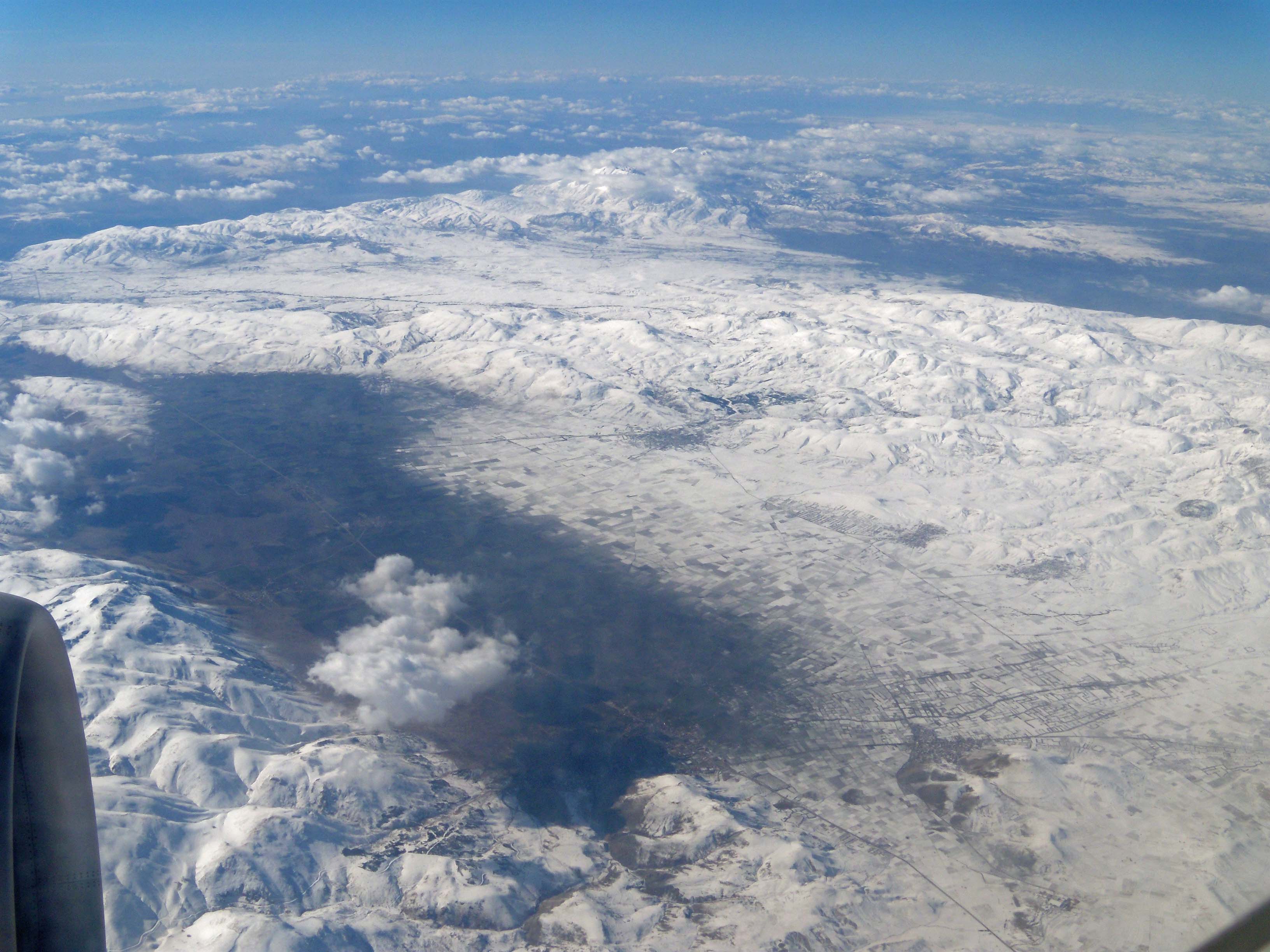
This idea occurred to me during my trip to Iran when I skirted the Zagros Mountains. In the winter of 330 BC, Alexander marched south using approximately the same route I was following a little later in the year, i.e., in April (see: The Zagros Mountains and the Persian Gates in Alexander’s footsteps).

I was plagued by a severe sandstorm that blew relentlessly during my three-day journey. Visibility was very low as the sands from the Mesopotamian Valley in modern Iraq were carried through the air. My clothes flapped around me as if they were to be torn away any moment while the sand was stinging my face and hurting my body. The wind whistled through the lunch place and the sand battered against the windows.

Inevitably my mind drifted back to Alexander as he must have known days like this. Traveling in the comfort of my air-conditioned vehicle was hard enough. However, when I stepped outside of this protective shell, I had a taste of what he experienced – if not here, certainly in other locations.

Curtius seems to be the only one to write about Alexander’s expeditions into the interior of Persia some time in Spring 330 BC, where he was troubled by heavy rain and “almost intolerable weather.” He even was stopped by heavy snow that had frozen solid; not for long, though, as he immediately started making his way, breaking the ice with a mattock, an example that his men promptly followed (see: Alexander amidst the pomp and circumstance of Persepolis).

While we take bad weather as a mere inconvenience, we cannot underestimate its far-reaching impact. That became clear after reading The Road to Oxiana by Robert Byron. Byron traveled to Iran and Afghanistan in 1933, using whatever means of transportation available. The weather conditions commanded his advance to a degree I did not expect. The Macedonian army must have faced similar conditions that hampered their progress to the same extent.

Byron is hit by what he calls a burning dust-storm, a good one hundred miles east of Hamadan, ancient Ecbatana. Near Bisutun, he witnessed great spirals of dust, “dancing like demons over the desert,” stopping his car and choking the passengers. 

Wind, rain, and ice are Byron’s main challenges. He attempted to drive south from Tehran to Isfahan in early February but was stopped some ten miles out. The road turned into a sheet of ice that partly thawed and had frozen again. The scene must have been spectacular, for he writes, “At this moment the sun rose, a twinkle of fire lit the snowy plain, the white range of the Elbruz was suffused with blue and gold,” A beautiful picture but a horrible travel condition.

A few days later, it rained for twenty-four hours. Byron was still stopped in Tehran by a “deluge of rain” in the last days of April. As he traveled further East via Damghan to Mashed, a route that approximately matches Alexander’s, “the rain fell like a bath-waste. For miles at a time the road was a river, the desert a flood, and every mountain a cataract.” The roads turned into fast-flowing rivers.

In Spring, Byron eventually reached Herat and continued due East to Kunduz. On his road to Balkh, where Alexander made camp and wintered in 328 BC (see: A view of the Karakum and Kyzylkum Deserts and Afrasiab, ancient Samarkand), Byron describes how “the rain came down in sheets. … every angle of the mountains was occupied by a cataract. … along that narrow ledge whence the red pinnacles rose into the clouds above, and whole ranges could be seen emerging from the clouds below…” A little further, he continues by saying that “the color of the landscape changed from lead to aluminum… The clumps of green trees, the fountain-shaped tufts of coarse cutting grass, stood out almost black against this mortal tint”.

Mazar-i-Sharif fared much better in his last days of May. He described how the clouds gathered on the mountains each afternoon, although summer should have set in six weeks before. People said they had never witnessed such conditions. The weather one hundred years ago was as unpredictable as today. The rain that fell before Byron’s arrival in the city was enough to close the road to Kabul for a whole month! An entire village had fallen down in a nearby gorge. Just picture Alexander having to cope with such extremes!

After Kunduz, Byron turned West, following the river of the same name to the plain of Bamyan, crossing the stream nine or ten times over wooden bridges. I doubt these bridges existed in Alexander’s days when the army had to find a way through the water. In June, Byron heard that a landslide blocked the other side of the Shibar Pass. In fact, “heaps of liquid mud and pebbles concealing large rocks.” The travel conditions became increasingly drastic. “The crops below the road, already half destroyed by the rivers of mud, were now menaced by a further spate.”

Alexander probably took this same road in the fall of 327 BC when he left Bactria for India by the Shibar Pass (see: Alexander crosses the Hindu Kush a second time). Nobody mentions any landslides occurring, but they were undoubtedly recurrent because further down Byron’s road to Kabul, another dozen landslides prevented him from reaching the city. Was Alexander just lucky and under the protection of the gods, one wonders?

The crossings of the Hindu Kush, in turn, have been pictured very well by Steven Pressfield in his book The Afghan Campaign. He describes the pure horror and misery the army endured in their daily lives of survival (see: From Afghanistan into Bactria across the Hindu Kush). Arrian, of course, gives us the facts but Pressfield, with his skills as a military writer, adds the human experience to the expedition.

Picking up Byron again, we read how on the road from Kabul to Ghazni – which Alexander traveled in the opposite direction to cross the Hindu Kush into Bactria – “two lorries were completely wrecked by the stream … the Kunduz ferry has overturned and sunk, drowning five women.”

Reading our history books, we are far from realizing that traveling or leading an army was a dangerous enterprise. Not only because of the enemies that had to be subdued but also because of the terrain and the weather conditions, which, as I said above, were seldom mentioned or recorded.

Tuesday, April 6, 2021

The fertile valleys of the Hindu Kush

Atlas Obscura is a newly created site (2021) aiming “to inspire wonder and curiosity about the incredible world we all share”. In fact, it was an article about the preservation of grapes in the foothills of the Hindu Kush that caught my attention. 

The location is the village of Aqa Saray at about half an hour drive north of KabulAlexander land, as far as I’m concerned. The place is described as being surrounded by vineyards and fruit trees. 

When Alexander arrived in the area in late 330 BC, he realized that it was too late in the year to march across the Hindu Kush (see: From Afghanistan into Bactria across the Hindu Kush). For that reason, he settled his army near Begram (later being renamed as Alexandria-in-the-Caucasus) at the junction of the Cophen (Kabul) River and the Panshir River overlooking a broad plain framed with snowy peaks. The army got a breather of several months in this valley where they found food and fodder in abundance. 

The fertile soil and dry-warm climate are ideal for apple, apricot and cherry trees to grow, as well as for vineyards. Presently, the production of grapes is officially estimated at 1.5 million tons. Further south, it is mainly pomegranates and melons. In winter, however, the snow falls heavily over the Hindu Kush and the mountains are covered with some twenty meters of snow. 

The climate has not changed much since Alexander’s days, so it is easy to imagine that the local people still live the same way as they did then. 

Here in Aqa Saray, there seems to be a living proof of that old heritage being kept alive. They actually are using containers made of mud-straw which they call kangina to preserve their grapes. The containers actually seal off the contents and keep out air and moisture – not unlike our modern plastic containers. The result is truly astonishing, particularly for the preservation of their grapes as they look perfect and remain fresh for at least five or six months, i.e., all through the winter! 

The above article mentions that this technique existed for centuries in these parts of Afghanistan and I can’t help wondering for how many centuries. Maybe all the way back to the days Alexander and his Macedonians occupied the land? 

The making of these containers has no secret. The villagers use the available clay and mix it with water and straw to obtain the desired consistency to create the bowls. They then are left to dry in the sun for approximately five hours. Once the recipients are ready, the grapes are put inside and the containers are sealed with more mud. The Taifi grape is preferred since it has a thicker skin and is better adapted for this kind of conservation technique. These preserved grapes are one of the favorite dishes served during the Nowruz or New Year meals to the many guests who come together for the occasion. 

It would be interesting to be able to turn back the clock of time, wouldn’t it?

[Pictures are from the Atlas Obscura]

Thursday, June 25, 2020

An eye for beauty in spite of the daily challenges

On a lovely autumn day, I was enjoying a picnic high up the hills among the ruins of Tlos, overlooking the Xanthos Valley. My mind automatically drifted away to Alexander, who must have ridden down this very valley towards Patara, Letoon, and Xanthos. I pictured him proudly riding his faithful Bucephalus, who was happily shaking his colorful tassels and twinkling bells.

In my pleasant mental picture, I imagined a good-humored Alexander enjoying the ride and the beauty of the land with Hephaistion at his side. No history book will mention this, of course. The landscape, roads, or weather conditions are no topic unless they reach extremes.

The few such exceptions our historians picked up are, for instance, the blizzards that hit the army on the passes of the Hindu Kush, the never-ending monsoon rains in India, and the flash flood in the Gedrosian Desert. Otherwise, we can only use our imagination, and that is not easy since most of us have not traveled to those faraway lands.

I feel privileged to have trodden in the footsteps of this great conqueror on several occasions, but to truly appreciate what is involved, we would have to venture out on foot. Only a handful of braves have set out on such an adventure. Traveling by plane or car, as is common nowadays, does not allow us to experience the impact of the elements. The wind, the rain, the heat or the cold remain blocked until we step outside of our metal cocoon. We miss out on the smells of the land, the dust, the fog, the crispy frost in the air. The most common sounds of bleating sheep, mooing cows, the songs of the birds, and the laughter of children are stifled entirely.

The topic of the weather fully hit me when I drove south along the Zagros Mountains in a relentless dust storm. The sands from Mesopotamia were carried through the air in sweeping gusts. As long as I sat inside the comforts of my vehicle, I only noticed a hazy landscape, but as soon as I left my protective shell, the grains hit me in the face, stinging me with thousands of needles. The wind was tearing at my clothes, the sand was crushing between my teeth, and breathing became difficult. Alexander must have known such days. 

The role of the landscape and the climate during Alexander’s campaign became even more apparent to me after reading “The Road to Oxiana” by Robert Byron. This book is a true eye-opener when it comes to envisioning the full scale of his daily challenges.

In 1933, Byron traveled from Damascus to Baghdad and crossed Persia to finally reach Afghanistan one year later.  It is quite exciting to discover that long stretches of his route match the itinerary taken by Alexander more than 2,000 years earlier. The landscape is a commanding factor common in both cases. Then and now, roads run along the same rivers, pass the same oases and towns, skirt the same deserts and mountains, and use the same passes and goat tracks. I enjoy his descriptions of the many valleys in full spring bloom in Central Asia, where the fiery red poppies rule the fields as they still do in Alexander’s homeland. They are a welcome breather after witnessing the barren deserts with their frequent dust devils whirling around.

Byron hitchhiked on board lorries but also traveled by car or on horseback. Despite modern means of transportation, he did not move much faster than a traveler on foot would. Roads were often impassable because of flooding or flash floods that washed away entire portions, including bridges or other rudimentary crossings.

He used old caravanserais when there was no local governor or friendly Brit around to offer him a room for the night. Lodging was, more often than not, uncomfortable and dirty. He generously recounts the folklore details of such encounters, and it seems to me that life has not really changed much since the days of Alexander.

As I read on, I search for those landscapes and cities that most likely have seen the Macedonian army marching through. Places like Ecbatana, Persepolis, Pasargadae, Balkh, Kabul, and Peshawar, the crossing of the Elbruz Mountains towards the Caspian Sea, and the perilous trek over the Hindu Kush.

Byron describes a poignant moment as he descends to the Caspian Coast. In a few minutes, the world of stone, sand, and mud he had endured since Damascus turned into one of green-leafed trees and bushes. The everlasting drought made way for moisture as even his body somehow returned to its natural buoyancy. I imagine Alexander and his dust-covered Macedonians must have experienced the same kind of refreshing relief.

In as far as possible, Alexander used the well-maintained Persian Royal Road. Once beyond that network, it came down to finding tracks and trails. It appears that Byron had a rather similar experience, and his worst progress was made after he left Persia to enter Afghanistan.

The sudden changes in the weather pattern are widespread in that part of the world, and Byron truly undergoes these extremes. He tells how it rained all night, how the river had subsided but rose again fast, four feet deep at times. Of rain falling like bath-waste turning the road into a river for miles in a row, flooding the desert, and turning every mountain into a cataract. He describes the dark skies as cloud-wracked set against inky jagged hills.

At one time, after passing the Paropamisus, he labors for an hour and a half, ankle-deep in freezing slush, to lever away the rocks blocking the road. Landslides were common, and he mentions how not one but a dozen such landslides prevented him from reaching Kabul overnight. A mile beyond the Shibar Pass across the Hindu Kush, which Alexander also used, Byron hits more landslides, heaps of liquid mud and pebbles concealing large rocks. The crops below the road, already half destroyed by a river of mud, are then menaced by a new spate.

Another exciting feature that is not mentioned in our history books either is the qanats. A very recognizable and ingenious water management system from antiquity that still exists today and is still functioning in some parts of the world. The quality of the river water could not always be trusted but the qanats carried the precious fluid from the snow level high up the mountains or from clean underground water tables (see: The qanats, one of the greatest inventions of mankind).

Earthquakes were another frequent occurrence at every stage of Alexander’s route. Surprisingly, the sudden shaking that rocked tents, as well as men and beasts, are never mentioned either. They probably were prevailing events not worth talking about.

No, this way of traveling is definitely not for the faint-hearted. Yet Alexander and his brave Macedonians constantly faced the elements. However, I like to believe that many, and especially Alexander had an eye for beauty as well. Byron tells us, for instance, that he reached the most beautiful part of his entire journey at the foot of the Hindu Kush. Of all places! After leaving the river, the road constantly climbed not in twists but followed a succession of steeply sloping saddles leading from ridge to ridge. I have seen pictures of this road in a presentation at the exhibition “Afghanistan, hidden treasures from the National Museum, Kabul and they entirely match Byron’s description.

On the other hand, flowers must have been plentiful in antiquity creating landscapes that were familiar to Alexander. Nowadays, they have mainly disappeared from our cities and our concrete roads. I fondly recall the Macedonian fields covered with an array of spring flowers ranging from the white chamomile and pink hollyhock to the deep-red poppies and purple wild onions The explosion of colors over the rolling hills felt like a homecoming. The land was pleasantly green, crossed by refreshing clear streams tumbling down from higher elevations under the blue sky filled with fleets of puffy clouds. Yet, I came across the same picture in many other places further east to Turkey and beyond.

Truly, so much, so very much remains to be discovered and disclosed on Alexander’s whereabouts!

Saturday, March 2, 2019

Punjab, Land of Five Rivers

One close look at the map will make you realize that Punjab is an enormous alluvial plain that counts far more than the five main rivers. Situated at the foot of the Himalayas, it covers a surface of over 50,000 square kilometers. Its watershed is fed by snow and glacial meltwater from the world’s highest peaks, like the Karakorum, the Hindu Kush, and the Himalayan Mountains.

The Achaemenids had only conquered the lands west of the Indus, meaning that once Alexander crossed this mighty river, he entered uncharted territory. Modern historians do not spend much time following the king’s march further east and his countless river crossings but instead focus on battlefields, sieges, and other ruthless fights. However, each and every crossing, including the numerous tributaries, is an enormous logistic enterprise. It makes you wonder how many of these rivers, streams, and waterways the Macedonians had to cross by any means available. That alone is a gigantic task!

After taking the Aornos Rock, Alexander headed for the Indus River, where Hephaistion had worked hard to build a pontoon bridge across the river as well as a fleet partly new and partly reassembling the elements which had been carried along. The crossing of the Indus took place at Ohind, modern Hund, in north-western Pakistan (see: Alexander crossing the Indus at Ohind).

Once his troops reached the opposite bank, Alexander headed for the capital Taxila at the junction of the major trade routes from Bactria, Kashmir, and the Ganges valley. This was the realm of Omphis, the son of King Taxiles, who had visited Alexander while he was still in Bactria and died before he arrived in India. Besides sending provisions to Hephaistion during the construction works, King Omphis welcomed Alexander with 200 silver talents, 3,000 oxen, 10,000 sheep, 30 elephants, and 700 Indian cavalry and 5.000 infantry.

The next river Alexander had to tackle was the Hydaspes (modern Jhelum), where the famous battle against King Porus took place (see: The Battle of the Hydaspes and the genius of Alexander), a masterpiece and a genius enterprise that was never surpassed.

As casually mentioned by Arrian, Alexander marched on through the populous region, taking some thirty-seven towns and many villages as the natives surrendered without much protest. Their lands were graciously handed over to King Porus.

The next obstacle was the Acesines River (modern Chenab) which was so broad and swift that Ptolemy found it necessary to mention it in his biography used by Arrian. It is hard to simply imagine a three kilometers wide river and how much one could see of the opposite bank. The Macedonians used boats to get across, but navigation among the rocks was a true challenge, and many were broken up, and the men were swept away by the current. The floats for the baggage and horses fared much better as they were far more shallow than the boats, but the trip was nevertheless one more logistic challenge.

The Hydraotes River (modern Ravi) was another major river on Alexander’s path, and as he marched through these lands, most Indian tribes surrendered without resistance. Those who refused were, of course, taken by force. Sangala was such an exception (see: The siege of Sangala). The tribes nearby the city had sought and found refuge inside its strong walls. Eventually, Sangala was taken by an assault in which up to 17,000 Indians were killed while over 70,000 were taken prisoner.


The last of the five major rivers was the Hyphasis River (modern Beas). Here, the Macedonians bluntly refused to follow Alexander anywhere closer to the edge of the world despite his eloquent and fiery speech. This was a severe blow to the king’s ego and pride, but he issued the order to retreat after three days.

Obviously, Alexander withdrew in style, and after building twelve altars (see: Alexander erected twelve altars on the banks of the Hyphasis) to thank the gods for having led him so far as conqueror and leaving an impressive memorial to his own accomplishments, he turned around having to cross the Hyphasis, Hydraotes, and Acesines once again. He sailed down the Hydaspes to ultimately reach the Indus River.

Some scholars consider Alexander’s experience in Punjab as useless and a waste of time, but it is hard to believe that he would do anything without reason. He would not endanger the life of his Macedonians lightly, and he certainly would not have invested nine months of this life on a sole whim. Judging Alexander’s conduct with today’s eyes is impossible. Besides, we only have sparse historical documentation to support his decision-making.

Monday, January 7, 2019

Alexander in the snow

When we think of Greece, we automatically have mental pictures of sun-drenched beaches and blue skies but winter can be harsh especially in the north.


The province of Macedonia, Alexander’s homeland, has started this New Year under serious snow storms, which offered unusual and eerie pictures.

Thessaloniki made headlines with houses, boulevards and monuments covered with snow and I found it very rewarding to find both Alexander and Philip contemplating nature as they must have done 2,500 years ago. They have seen worse, of course: Philip during his repeated Balkan campaigns and Alexander in the Hindu Kush Mountains.


This is something we should keep in mind when standing in front of the statues of these two great men.

Wednesday, January 17, 2018

The Khyber Pass into India

On their return from Sogdiana (see: End of Alexander’s Campaign in Central Asia), the Macedonians spent a well-deserved rest of six months at Alexandria-in-the-Caucasus (Begram) in the heart of the Kabul Valley. Here, Alexander worked hard to reshuffle and reorganize his army.

[Map is from the Encyclopaedia Britannica]

His strategic phalanx was dismantled since it no longer served its purpose after the Bactrian guerilla wars. The mounted Lancers joined the Companion Cavalry together with the skillful horsemen from Bactria and Sogdiana, to which he added 2,000 horse-archers from Spitamenes’ nomads.

On another level, the commanding posts needed to be redistributed after the execution of Philotas and Parmenion and the murder of Cleitos. Their detachments were split between Ptolemy, Hephaistion, Perdiccas, and Leonnatus. The Royal Shield Bearers were promoted to the title of Silver Shields (Argyraspids), led by Seleucos and Nearchus, under the supreme command of Neoptolemus. The Royal Squadron of Companions remained under Alexander’s own command. These Cavalry Commanders and trusted squadron leaders enabled him to divide his army more freely between different locations at any one time.

That winter of 327 BC, the entire army was on the march again, with their forces divided in two. Hephaistion and Perdiccas are sent ahead to the Indus in order to prepare the crossing of that river with half the Companions and all the mercenary cavalry. The timing is well chosen to avoid the summer heat upon arrival in India. With the other half of the troops, Alexander starts his march up the Kunar Valley into the Swat Valley in modern Pakistan.

There is little or no information about the expedition of Hephaistion and Perdiccas as they head east. It is clear that to reach the Indus River, they must cross the Hindu Kush Mountains again. The obvious route this time leads over the Khyber PassEven today, the main road from Kabul to Peshawar runs over the same mountain pass.

The Khyber Pass is situated at an elevation of 1070 meters and is 53 kilometers long. The passage varies between 3 and 137 meters in width, meaning that the Macedonians had to cope with the inevitable bottlenecks. On top of that, the Khyber Pass is walled in by steep cliffs towering 200-300 meters above the men’s heads.

It is not known how long it took Hephaistion and Perdiccas to get across the pass, only that they marched to Peucelaotis and hence to the Indus. Their instructions, according to Arrian, were that they had to take all the places they encountered, either by force or by agreement.

Peucelaotis, however, resisted. Hephaistion besieged the town for thirty days, after which the defenders surrendered, maybe simply because their governor, Astes, was killed. The newly appointed governor was a certain Sangaeus who had deserted Astes some time before to join Taxiles. This made the man trustworthy.

Eventually, Hephaistion and Perdiccas reached the River Indus at Ohind/Hund (near modern Attock) in PunjabHere, they built a fleet of thirty-oared galleys and a pontoon bridge of linked boats spanning the river, which at this point is at least 400 to 500 meters wide. This operation is not to be underestimated, for although the bridge was constructed far upstream in the Punjab region, the river is fed by snow and glacial meltwater from the Karakorum, the Hindu Kush, and the Himalaya Mountains, and its annual flow is known to be two times faster than that of the Nile or three times that of the Euphrates and the Tigris combined.

Even in antiquity, historians tend to focus solely on Alexander, but his generals also excelled in their missions, which were multiplied from Sogdiana and Bactria onwards. The War of the Diadochi that broke out after Alexander’s death certainly proves – if a proof is needed – how capable each and every one of his generals was. Well, they certainly had an excellent master!


[The Black&White picture is taken by John Burke, 1879-1880]

Wednesday, August 16, 2017

Alexander crosses the Hindu Kush a second time

After two years of intense guerilla fights throughout Sogdiana, Alexander had finally caught Bessus, eliminated Spitamenes and restored a relative peace in Bactria by marrying Roxane. The time had come for him to head for India.

Until now, I was convinced that Alexander returned from Bactria via the Khyber Pass but when I tried to trace where the idea came from, I was in for a surprise. There is no excuse, I should have taken a closer look at the map to realize that the Khyber Pass lies in fact on the way from Kabul to Peshawar and not between Bactria and Afghanistan.

With that question solved, I needed to find out which pass Alexander had used leaving Bactria. The antique authors are disappointingly scant in reporting this part of his campaign. Plutarch, Justin, and Diodorus do not mention the crossing of the Hindu Kush – a formidable barrier under all circumstances - on Alexander’s return and Curtius simply states that Alexander set out for India in order not to foster idleness. Arrian seems to be the only one to be more specific telling us that by the end of spring Alexander began his march for India, that he crossed the Indian Caucasus, and ten days later reached Alexandria(-in-the-Caucasus), the city he had founded during his first expedition into Bactria. Strabo merely tells us that Alexander crossed the Hindu Kush and settled his veterans and mercenaries together with natives at Alexandria-in-the Caucasus.

This meant that I had to rely on modern historians and their research on the matter. Unfortunately, they do not agree among themselves about Alexander’s route and it seems that they all have a theory of their own.

Frank Holt (Into the Land of Bones) has come to the conclusion that Alexander marched his army over the Shibar Pass. With the winter snows gone, the trek went smoothly and without great logistical problems.

Robin Lane Fox (Alexander the Great) says that Alexander used the same pass as earlier, meaning the Khawak Pass (see: From Afghanistan into Bactria across the Hindu Kush). This time in June, the march was at a leisurely pace and took only ten days. The snows had melted and Alexander could rely on food stored in the Sogdian fortresses on the way and on the high grazing grounds for the animals. The army spent a pleasant summer at Alexandria-in-the-Caucasus (Begram) thus avoiding an invasion of India in appalling heat.

A.B. Bosworth (Conquest and Empire) simply mentions that Alexander crossed the passes of the Hindu Kush into the Paropamisadae in ten days and reinforced the city of Alexandria-in-the-Caucasus.

Michael Wood has concluded that Alexander crossed the Hindu Kush via Bamyan, which implies that he took the Shibar Pass.

Donald Engels (Alexander the Great and the Logistics of the Macedonian Army) in turn sticks to the Salang Pass since this pass is shorter and has often been used by armies in a hurry. Engels states that the army re-crossed the Hindu Kush in late spring but could not forage for grain along the route because harvest at these high altitudes does not occur until July or August. They had to rely on supplies collected by Hephaistion throughout Bactra before departing.

In a footnote, the author refers to the optional Kushan Pass, just east of the Salang Pass, that has been put forward by other historians, but then this Kushan is seldom used because it is precipitous and treacherous – not exactly recommendable for an army. The Salang Pass, on the other hand, although as fast as the Kushan is much safer. He rules out the Shibar Pass which is longer than the Khawak. Given the ten days it took Alexander to cross the Hindu Kush, Engels’ choice is narrowed down to either the Salang Pass or the Kushan Pass.

All these theories take me back to the map of Afghanistan and of the Hindu Kush in particular. Based on the above, it comes down to choosing between the 3,878 meter-high Salang Pass and the Kushan Pass rising at 4,370 meters located due west of the Salang Pass. Interestingly, this pass is less than one kilometer away from the modern Salang Tunnel built in 1964 with the financial and technological support of the Soviet Union. This meant that traveling time is cut down drastically although repeated avalanches tend to trap the vehicles inside the tunnel, making the voyage still a dangerous one.

Glancing at Google maps provides another quite impressive image of the landscape the Macedonian army crossed. Even with enough food and fodder, we have to admire these sturdy men trudging over narrow paths, through deep ravines, across icy rivers and over rocks of all sizes and shapes. Nobody, not even Hannibal comes close to Alexander’s exploits in the Hindu Kush. In the end, I have to agree with David Engels and agree on the Salang Pass.

We should remember that Alexander’s Asian campaign is much and much more than a series of battles and sieges. Marching often through forbidding landscapes, coping with extreme heat, thunderstorms, crosswinds, dust, rain, sleet and ice, the Macedonians have seen it all but the king set the example by leading his troops over each and every obstacle. The Hindu Kush is just one of these obstacles, although a major one that cannot be stressed enough.

[First picture shows the Shibar Pass by František Řiháček -original prints, CC BY-SA 3.0, - The two other pictures show the Salang Pass by Scott L.Sorensen - My Personal Picture, CC BY 3.0 and by Spc. Michael Vanpool (U.S. Armed Forces) respectively.]