Alexandria's founded by Alexander

Alexandria's founded by Alexander the Great (by year BC): 334 Alexandria in Troia (Turkey) - 333 Alexandria at Issus/Alexandrette (Iskenderun, Turkey) - 332 Alexandria of Caria/by the Latmos (Alinda, Turkey) - 331 Alexandria Mygdoniae - 331 Alexandria (Egypt) - 330 Alexandria Ariana (Herat, Afghanistan) - 330 Alexandria of the Prophthasia/in Dragiana/Phrada (Farah, Afghanistan) - 330 Alexandria in Arachosia (Kandahar, Afghanistan) - 330 Alexandria in the Caucasus (Begram, Afghanistan) - 329 Alexandria of the Paropanisades (Ghazni, Afghanistan) - 329 Alexandria Eschate or Ultima (Khodjend, Tajikistan) - 329 Alexandria on the Oxus (Termez, Afghanistan) - 328 Alexandria in Margiana (Merv, Turkmenistan) - 326 Alexandria Nicaea (on the Hydaspes, India) - 326 Alexandria Bucephala (on the Hydaspes, India) - 325 Alexandria Sogdia - 325 Alexandria Oreitide - 325 Alexandria in Opiene / Alexandria on the Indus (confluence of Indus & Acesines, India) - 325 Alexandria Rambacia (Bela, Pakistan) - 325 Alexandria Xylinepolis (Patala, India) - 325 Alexandria in Carminia (Gulashkird, Iran) - 324 Alexandria-on-the-Tigris/Antiochia-in-Susiana/Charax (Spasinou Charax on the Tigris, Iraq) - ?Alexandria of Carmahle? (Kahnu)
Showing posts with label Polybius. Show all posts

Tuesday, April 2, 2024

Bylazora, the last Macedonian Palace

The Paeonians occupied the land north of ancient Macedonia and functioned as a buffer zone with the Dardanians on their northern border. Bylazora, in fact, was situated in a commanding position at the natural pass leading from Dardania into Macedonia. 


Philip V of Macedonia, who ruled from 221 until 179 BC, captured Bylazora in 217 BC. By blocking the Dardanian access road to Macedonia, he freed his country from its repeated menacing raids. PerseusPhilip’s son, who succeeded his father, sent mercenaries to Bylazora to confront the Romans, but he was defeated in 168 BC. He was taken to Rome to be shown in their victory parade, together with the incredible wealth of Macedonia. The rich kingdom became a mere Roman province. 

Although Bylazora was the largest city of Paeonia and was mentioned by Livy and Polybius, its location remained a mystery. It was tentatively identified with (Titov) Veles, but the results were inconclusive. As so often, the city was discovered by accident in 1994. Road works exposed a buried pool-like building close to modern Sveti Nikole in the Republic of North Macedonia, some 50 kilometers southeast of Skopje, between the Axios and the Strymon Rivers. 

Excavations started in 2008 after the Museum of Sveti Nikole invited the Texas Foundation for Archaeological & Historical Research (TFAHR) to a joint cooperation. 


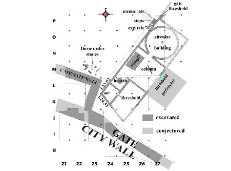
It was a slow process of searching for clues that started at the top of the hill, the Acropolis. Soon, a section of the northern defensive wall was exposed, followed by the discovery of a ramp leading up to the Propylon. Next, a Stoa with Doric columns was identified and dated to the days of Philip V based on a similar gallery built by Attalus II in Athens. 

A long wall and successive rooms were unearthed, making the archaeologists realize they had found the Palace of Philip V and Perseus, the last two kings of Macedonia. 

The first room they explored had all the characteristics of a kitchen, with a fireplace, much pottery, plates, vessels, and amphorae from the 3rd-2nd century BC. The walls were covered with a thick layer of plaster with traces of paint. Followed a room with columns and capitals, which was named Ante-room since it connected to a more important Tholos. For those who visited the Palace of Aegae in Greece, that space is very recognizable. On the other side of this Tholos lies the Entrance Hall, which in turn is connected to the Vestibule. This large room opened onto the Outer Courtyard via a monumental staircase. 

Keeping the layout of the Palace of Aegae in mind, the archaeologists projected the same series of rooms around the Inner Courtyard. The picture seems to fit perfectly. It also matches the Palace of Dimitrias, situated just south of Volos in Greece. The city was built by Demetrios Poliorcetes when he was king of Macedonia, i.e., 294-288 BC. 

Until now, and as opposed to Aegae and Pella, I had no knowledge of the Macedonian Palaces of Bylazora or Dimitrias. The destruction of the Palaces of Aegae and Pella by the Romans is well-documented. Dimitrias, however, was entirely dismantled, and it is assumed that the same happened in Bylazora, although it was never finished. 

Much more pertinent information with clear maps and unique details can be found in this lecture given by Dr.William J. Neidinger of the TFAHR.

[Pictures from TFAHR]

Sunday, April 25, 2021

The secret behind the Astragal game

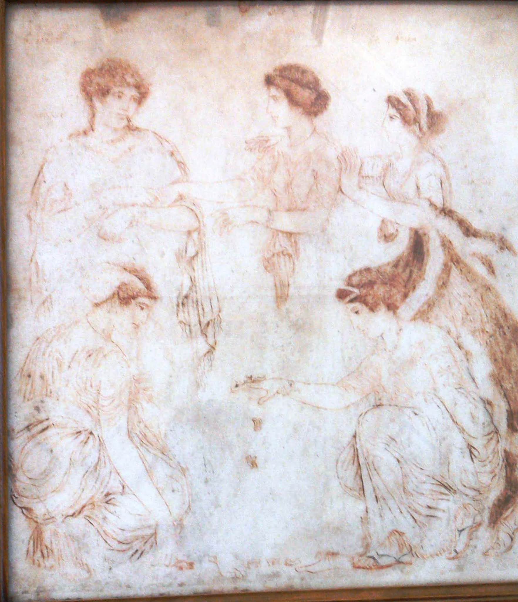
During my last visit to the National Archaeology Museum in Naples, I was fascinated by a simple sepia drawing representing girls involved in a knuckle-bone or Astragal game. It was displayed with other smaller colorful frescos and this picture obviously stood out because of its fine lines. 

It was a plain tuf slab painted with delicate black and brown strokes dating from the 3rd century BC and recovered from Egnazia in southern Italy

Initially, the knuckle-bones were designed for children and used just like dice having four sides rather than the usual six. 

It doesn’t look like a boy’s game but I am sure that it would have been familiar to Alexander. However, the secret is that these bones could also play a role to transmit secret messages as explained by Aeneas Tacticus.  This Greek writer, who Alexander must have been aware of, made headlines as being the first author to pen down a complete guide to securing military communications, including the best tactics to defend a fortified city. Also, the earliest hydraulic semaphore system is attributed to Aeneas Tacticus by Polybius. 

This means that this rather innocent toy could play an important role to send encoded messages. 

Earlier this year, Karawansaray Publishers shared an article on the subject and kindly quoted Aeneas Tacticus describing how to encode a message using these sheep bones. 

The most secret method of all for sending messages, but the most difficult, namely, that without writing, I shall now make clear. It is this. In a sufficiently large astragal bore twenty-four holes, six on each side. Let the holes stand for letters, and note clearly on which side begins Alpha and the following letters that have been written on each particular side. Then whenever you wish to communicate any word by them, draw a thread through them, as for instance, if you wish to express Aineian by the drawing through of a thread, begin from the side of the astragal on which Alpha is found, pass the thread through, and omitting the characters placed next to Alpha, draw through again when you come to the side where Iota belongs; and disregarding the characters following this, again pass the thread through where Nu happens to be. And again passing by the succeeding letters draw the thread through where Ei [the original name for Epsilon] is found. Now continuing in this way to write the rest of the communication, pass the thread into the holes in such a manner as that in which we just now wrote the name. Accordingly, there will be a ball of thread wound around the astragal, and it will be necessary for the one who is to read the information to write down upon a tablet the characters revealed by the holes. ... [to decipher the message (in reverse)] A piece of wood about 20 centimetres long perforated as many times as the letters of the alphabet, and the thread were then in the same way drawn into the holes. 

The marvelous drawing exhibited in Naples is a far cry from secret messaging as the ladies clearly enjoy their play. I was especially admiring the details of the lady at the bottom right in this picture. Not only are the folds of her dress standing out, but also the delicate line for her sandals and most of all her splendid long wavy hair!

Monday, May 11, 2020

Travelling in the opposite direction of Alexander the Great

It is 330 BC when Alexander is marching through the heartland of Persia. That same year, a very little-known Greek merchant named Pytheas started an astonishing voyage of his own in the opposite direction. There was much more happening on planet Earth than Alexander’s campaign in the east.

This Pytheas made such a name and fame that contemporaries and authors ended up moving his story to the lands of myths and legends that were discussed in belief and unbelief for centuries.

Our merchant from Massilia (modern MarseilleFrance) was also known as a skilled navigator, mariner, and astronomer. His treatise On the Ocean, unfortunately, has not survived but has been quoted extensively throughout antiquity by people like Diodorus, Eratosthenes, Strabo, Polybiusand Pliny the Elder. Each one of them interpreted and judged Pytheas in his own way, often reaching contradictory conclusions. Truth and fantasy went hand in hand and were so intertwined that nobody will ever be able to get to the bottom of the fact, I’m afraid.

Pytheas’ book was a kind of maritime log loaded with astronomical, geographic, biological, oceanographic, and ethnological observations that still catch the attention of modern scholars. The log also contained practical information with descriptions of the coastal landmarks and even astronomical notes.

The travel account was written in Greek around 325 BC. At that time, Nearchus was sailing from the Indus to the Persian Gulf to be reunited with Alexander, who had survived his death march through the Gedrosian Desert.

Pytheas traveled through uncharted territory as well. Besides, we can only speculate about the route he took from his hometown, Massilia. After sailing through the Pillars of Hercules (modern Strait of Gibraltar), he then proceeded along the Atlantic coastline of Spain and France. He probably crossed the English Channel somewhere in French Brittany. Britain was a well-known source for tin, amber, and gold that was exported via Gaul to the Mediterranean world. 

Once in Britain, the intrepid navigator probably continued along the coast of Wales and onward to Scotland. Here, Pliny mentions Pytheas’ arrival at the Orcades Islands, north of Britain. These islands are generally recognized as the Orkney Islands.

More challenging was his route onward, which is thought to have taken him as far north as Iceland and the Arctic Ocean, where the giant Hyperboreans from Greek mythology lived. Modern scholars do not agree about Iceland, which Pytheas called Thule, as mentioned by Strabo, but believe that the merchant reached Norway instead. In any case, he experienced the nearly continuous daylight typical at this high latitude during the summer months. 

Just one day sailing out of Thule, he reached what he called the “Congealed Sea” – a way to tentatively describe the frozen Arctic OceanStrabo describes the place as a sea lung, where neither earth, water, nor air existed but where all things were suspended together.

On his way back, Pytheas may have traveled down the east coast of Britain, past “Kantion,” which may refer to the Kentish peninsula. There is evidence that he continued along the northern coastline of Europe, maybe meeting the Germanic people and perhaps venturing to Heligoland (Helgoland), a valuable source of amber. Some scholars argue that Pytheas sailed to the Baltic Sea as far as the Vistula River, now in Poland. It is not known when he arrived back in Massilia, but it is generally accepted that it was before 320 BC when his book was first cited by the writer Dicaearchus, a student of Aristotle.

It makes me wonder whether Alexander was aware of this travel expedition when he planned his own conquest of the western Mediterranean and the territories beyond. Julius Caesar likely used the book to acquire information about Britain and further northern areas. Copies of Pytheas’ work probably sat on the shelves of the great libraries of Alexandria and Pergamon, where it could and would be studied freely.

Whatever ancient and/or modern scholars may think of Pytheas, we cannot dismiss the fact that he went on a journey to explore the world by direct observation, not unlike the young British young men who went on the Grand Tour in the 18th century.

Saturday, December 22, 2018

The Histories by Polybius, A new translation by Robin Waterfield

The Histories by Polybius (ISBN 978-0199534708) are far less known than, for instance, The Histories by Herodotus and cover an entirely different period. As a result, the author and his book merit being put in a well-deserved spotlight.

Few people have ever heard of Polybius, and it may be useful to introduce him with a short biography. Polybius was born ca. 200 BC, probably in Megalopolis, the capital of the Achaean League (a federal organization of the Peloponnesus). His father played a leading political role, and Polybius, at the age of thirty, was elected deputy leader of the League. But his life changed dramatically when Macedonia lost its independence at the Battle of Pydna in 168 BC. This had far-reaching consequences for the rest of Greece. The Achaean leaders were deported to Rome, including Polybius, who spent seventeen years in the capital.

However, as a highly educated Greek, he soon befriended Scipio Aemilianus, one of the most powerful men in Rome at that time. He also became friends with Prince Demetrius, held hostage in Rome, and managed to arrange his escape from the city in 162 BC in order to reclaim his place on the Seleucid throne.

Polybius accompanied Scipio during his campaign in Spain and went to Numidia, modern Tunisia. He tells us how he walked in the footsteps of Hannibal from Spain to Italy. In 149 BC, he was summoned to Carthage, where, using his diplomatic skills brought the Carthaginians to comply with the demands of Rome. Not for long, though, as two years later, Polybius joined Scipio again in his siege of Carthage. When that city fell, he traveled beyond Gibraltar to explore the coast of western Africa. For reasons that could not be determined, Achaea revolted against Rome in 146 BC and lost the battle; as a result, the League was dismantled, and proud Corinth was destroyed. Polybius apparently played an important role in the reconstruction of Greece, a gesture that was widely appreciated, as Pausanias tells us that many cities of the Peloponnesus erected statues in honor of their fellow countryman.

It is clear that Polybius led a very active life as a politician, general, and even as an explorer, and it makes one wonder when and how he found the time to write. Besides his Histories, he left us a study on tactics, a treatise on the habitability of the equatorial region, about the war of Rome against Numantia in Spain, and a biography of Philopoemen, a famous and skilled strategos of Achaea. Unfortunately, the largest part of his works has not survived.

Polybius’ Histories treat the rise of the Roman Empire in the Mediterranean in the period from 220 to 146 BC – a colossal job filling forty books of which only five have survived. Books 1 and 2 are basically an introduction to his work, leading to the battle for power between Rome and Carthage, which spills over into Book 3 with the victory of Hannibal in 216 BC. In Books 4 and 5, Polybius turns to the situation in Greece and the eastern Mediterranean before that same date in order to match the chronology in which he likes to report events. Of the following books, which are not necessarily straight history and treat, for instance of geography in Book 34, substantial excerpts also exist. From what transpires, he took the trouble to make a summary of his work in Book 40. So much precious information has, unfortunately, been lost over the centuries!

In his effort to explain what kind of constitutional structure Rome applied to conquer the world, it appears that in Book 6, Polybius developed a highly interesting theory about the recurrent cycle of government in which monarchy, aristocracy, and democracy alternate. In the same book, he described the constitution of Rome at length, giving us a unique insight into the great organizational skills of the Romans.

What makes Polybius stand out is his overall chronology reporting the events as they develop simultaneously in the eastern and western ends of the Mediterranean. It truly is a rare horizontal history and, what’s more, he is the only historian from the Hellenistic period whose work survived to such an extent.

Since the Punic Wars are treated in detail, I found this the best history I ever read without getting lost or confused one way or another in those repeated conflicts that lasted on and off for 118 years. To keep track of time, the year in which the events took place is handily quoted in the margin.

The translation made by Robin Waterfield is superb and reads with the clarity that is characteristic of him (see: Dividing the Spoils).

The book has a great Introduction without which the Histories would be very hard to understand. It also includes a handy chronology of the events covered in the book and a set of three maps, one of the Mediterranean and a detailed one for both Greece and Italy.

Friday, March 23, 2018

The fame of elusive Pelusium

When in 333 BC, Alexander took possession of Pelusium, situated on a branch of the Nile that has shifted since, it was a wealthy settlement as it contributed to his treasury with 800 talents (20 tons of silver and gold). It was his first stop in Egypt, as it was for all conquering armies before and after him.


Pelusium was not only the point of entry for invaders but also the departure point for Egyptian expeditions to Asia. In short, it was a place of substantial strategic importance and the second port of Egypt after Alexandria, as it served as a transit station for the goods coming from and going to the lands around the Red Sea.

Yet, despite its fame and importance in antiquity and the many sources, among which Herodotus, Polybius, Diodorus, Curtius Rufus, Arrian, Strabo, etc., the site of Pelusium, associated with modern Tell el-Farama has never been properly excavated. Antique sources describe the city as a bustling harbor with magazines and customs offices trading in salt, textiles, pottery, and fish. On the site, which is believed to be almost six kilometers long, we find the remains of a fortress and marble columns from a possible Roman Theater that closely resembles the one in Alexandria. There are remains of several necropolises, a hippodrome, fish tanks for garum, Roman baths with mosaics from the 3rd century AD, a stadium, many temples, and even a military installation.

However, the little we know about Pelusium is now threatened by the construction plans for a massive canal through the northern part of the Sinai Desert. This waterway is meant to bring fresh water to the city of El Arish, 60 kilometers from the border with Israel. Unfortunately, in that part of the world, nothing is simple. As early as 1991, archaeologists launched a project to survey the course of this canal to pinpoint any site that may be worth recovering before being destroyed by the dig works or, if possible, divert the route to save vast remains. It is no surprise that by 2010, both the canal and the archaeological project have been put on hold.

It seems that ancient Pelusium will not soon resuscitate from its ruins.

Wednesday, March 22, 2017

Pella and Gadara, two more settlements for Alexander’s veterans

When Alexander returned from Egypt in 331 BC, he marched along the coast of the eastern Mediterranean. How close to the coast may be subject to debate, but the fact remains that he had to send foraging parties into the hinterland. Alexander must have depleted much of the local provisions when he marched his troops through the region the year before, as did the fleet that supported him and his troops on their way to Egypt, especially when crossing the Sinai. This being said, it is very plausible that his foraging parties had to move further inland when he returned. To that purpose, they must have exploited the lands east of the Dead Sea, Jordan River, and the Sea of Galilee, and that is exactly where we find cities like Gerasa, Pella, and Gadara, which are said to be founded by Alexander.

The founding of Gerasa has been treated in an earlier blog (see:  Alexander founder of Gerasa). Some 45 kilometers north of that city lies the town of Pella (previously Pihilum) known to be named in honor of the city where Alexander was born. Pella flourished in Hellenistic times as it became a regional power in the maze of trade routes running through the city. It has been established that Pella was largely populated in Hellenistic times as it was a hub for merchants crossing the region (see: Apamea, heritage of Alexander). Under the rule of Seleucos, the city was renamed Apamea after his wife Apame.

After the death of Alexander, Gerasa and the neighboring territories were annexed by the Ptolemies in 301 BC. At some time during the third and second centuries BC, the Seleucids took hold of the area and undertook a thorough Hellenization till by 64-63 BC, it became a Roman province. The Romans, to properly govern Judea and Syria, created a Decapolis (see: Alexander, founder of Gerasa), a group of ten cities that shared the same language, commercial relations, and political status. Each city enjoyed a certain degree of autonomy with its own Semitic, Nabataean, Aramean, and Jewish culture. The members were according to PlinyDamascus (in Syria), Philadelphia (modern Amman in Jordan), Gerasa (now Jerash in Jordan), Scythopolis (now Beisan in the Jordan Valley, North Israel), Gadara (modern Umm Qays in Jordan) and once the capital of this Decapolis, Hippos (on the banks of Lake Tiberias in Israel), Dion (probably near Irbid in Jordan, but not yet discovered), Pella (in the Jordan Valley, northwest of Amman in Jordan), Canatha (now Qanawat in Syria) and Raphana (probably north of Umm Qays in Jordan, but not yet discovered either). As part of the Decapolis, these cities shared the common political, cultural, and commercial interests of the other members and enjoyed their Golden Age that lasted for about 150 years.

The Romans left their usual buildings, like theaters and temples, along familiar colonnaded streets in Apamea. It is hard to imagine in today’s desert-like landscape that these cities were blessed with fertile soil and plenty of water, making them favorite stops on the busy trade routes between Europe and Asia. Let us not forget that besides goods and agricultural skills, Greek culture and language widely spread.

Another 30 kilometers onward, we find the town of Gadara, today’s Umm Qays, near the northern border of Jordan with Israel and Syria in the hills above the Jordan Valley. Since Gadara emerged in the wake of Alexander the Great, as well as Pella and Gerasa, it shares most of its history. It became part of the kingdom of the Seleucids, and we know from Polybius that Antiochus III ruled here in 218 BC and that Gadara was coveted by both the Ptolemies and the Seleucids, who captured and recaptured it time and again, confirming the role it played on the trade routes with the east. The Seleucid kings renamed the city Antiochia or Antiochia Semiramis and even another Seleucia, as they turned the city into a center of Greek culture.

Gadara boomed under the Romans after Pompey conquered it in 63 BC. At that time, the reputation of the local poet Meleagros (131-61 BC) had already spread far and wide. He was a much-admired Hellenistic author who wrote an anthology of other poets – a true statement of the city’s high cultural level. Gadara certainly deserved its surname of “Athens of the East” when in the 2nd and 3rd centuries AD it became a center for philosophy, literature, and theater.

The ruins of Gadara are far less impressive than those of Gerasa, mainly since most of the city still lies underneath the old Ottoman village from the 18th-19th century that has been vacated in recent decades. The spooky streets and buildings are hiding the Roman living quarters. This settlement leans closely to the crumbling walls and has inherited its medieval name of Umm Qays

The very top of the hill has been carefully excavated and exposes many of the official buildings. It is always a delight to enter an ancient city over the Cardo, which here is paved with large blocks of black basalt. The Roman Theater on the right almost immediately calls for attention. It is entirely built of black basalt as well and offers seating for 3,000 people. This is generally called the West Theater, as there are remains of another theater on the north side of town, which has largely been dismantled by the locals and recycled for their own contemporary constructions, leaving an overgrown field. Unlike the usual eastern-oriented theaters, this theater is looking to the west so that the theater-goers would be sheltered from the strong eastern wind! The remains date generally from the first and second centuries AD and are overall in good condition. From the top tiers, one has a most wonderful view over this biblical land on the eastern bank of the Jordan River, where the Golan Heights and the Sea of Galilee shimmer on the horizon.

Back on the Cardo, one notices several vaulted spaces underneath the skene where once shops were set up. Even in antiquity, theater-goers could be tempted by food and drinks or other entertainment commodities!

Then the Cardo reaches the Decumanus, which has been well cleared and runs on for at least two kilometers to the west. Its black basalt pavement stands in sharp contrast with the white Corinthian limestone columns that separate the road from the sidewalk lined with shops of all kinds. The deep ruts in the pavement testify to the heavy traffic of carts with goods that were transported along the edge of this high plateau to nearby cities like Pella. In its heyday, this road ran all the way to the Mediterranean coast. Halfway there is an unknown sanctuary and a Nymphaeum next to still overgrown public baths from the 4th century.

Turning back, one encounters another large and very impressive Nymphaeum set in the same black-and-white stone combination as found on the Decumanus. To the right is an area called the Terrace Church, dating from the 6th century. This is a strange mixture of all kinds of Roman remains from the 2nd century, enhanced with columns from Byzantine and early Islamic times. It is not easy to figure out the pattern and discover a central square framing an octagonal space. Each corner of this octagon is marked by a black basalt column, and it is believed to have been an unusual inner sanctum. On the west side, there is a large entrance hall, and on the north side, another open space that looks like an atrium. This may have been a pilgrimage site for some important martyr, although no hard proof has been found so far. Like so many buildings in Gadara, this church was destroyed by the severe earthquake of 747 AD, after which the city was abandoned.

The Decumanus loses itself further east past well-preserved city walls embracing the skeleton remains of the Ottoman houses and their crumbling walls. There must be a hippodrome and a stadium out there somewhere, as well as an aqueduct, but apparently, not much has been exposed.

It is nearly impossible to look at Gadara or Gerasa beyond the Roman influence, for these cities originally did not have any Greek roots. Since they were founded by Alexander, they should be seen as a pure Macedonian concept. It is here that the first seeds of later Hellenism were planted, and this makes me wonder how much of the Macedonian influence went into the Alexandrias founded later on during Alexander’s campaigns.

Friday, December 4, 2015

Ecbatana, where Hephaistion died

Hephaistion died in Ecbatana in October 324 BC after being seriously ill with a high fever for about seven days. His symptoms may indicate a case of typhoid. When he seemed to have been over the worst and his appetite returned he is said to have consumed a whole chicken and a large bottle of wine. This was against his doctor’s orders, but Glaucias had left his patient to attend the games at one of the festivals organized for the entertainment of the troops. Alexander himself was at the theater when the news reached him that Hephaistion had fallen into agony and by the time he arrived at his friend’s bedside he had already died. The city was in mourning and its crenellations were shorn.

Today the city of Ecbatana has changed its name to Hamadan, literally meaning “the place of gathering”. It seems very few people remember Ecbatana’s name and fame from antiquity, once the capital of the Medes founded as early as the 8th century BC. After the conquests of Cyrus the Great in 549 BC, the city became part of the Persian Empire. After his death, it was re-conquered by the Medes but not for long since the new Persian king Darius I took it back in 521 BC (this victory is depicted in the large relief at Bisutun). Since then, the Achaemenid kings used Ecbatana as their summer residence, a custom that was imitated by later Seleucid and Parthian kings alike.

If we consult the Greek historian Polybius, we are told that Ecbatana was the richest and most beautiful city in the world. It had no walls, only the palace which was set on an artificial terrace had fortifications that were approximately 1,250 meters long. This means that the palace stood on a plateau of approximately 300x300 meters (as compared to Persepolis’ 450x300m). Five hundred years earlier, Herodotus, on the other hand, wrote that the city was surrounded by seven concentric walls in different colors with the most inner walls plated with gold and silver. People were dwelling around the wall, meaning outside the palace walls on the fertile plain. These are apparently the only ancient texts we have to go by, and in the contradictory and confusing descriptions, we may wonder whether they are talking about the city walls, the palace walls, or maybe even the walls of the citadel. It all seems to be jumbled together.

Polybius does mention, however, that most of the precious metals were stripped off during the invasion of Alexander, but I can hardly believe this especially if he means the palace walls. Further stripping is said to have taken place by Antigonus Monophthalmus and by Seleucos, which is more plausible in my eyes.

Arrian, in turn, mentions the citadel of Ecbatana where the captured Persian treasure was kept under the watchful eye of Harpalus.

I was quite surprised to hear that there were ruins of old Ecbatana left at all and I only see dusty hills behind a fence. It seems the French dug here first, but since 1995 Iranian archaeologists have been excavating the site with unclear results so far. They may have found only the Parthian level, meaning that the Achaemenid and the Median levels are to be sought much deeper – or as suggested in 2007, at another nearby location. The problem is that part of modern Hamadan is built right on top of the ancient site. Good luck to future archaeologists!

Alexander visited Ecbatana twice. The first time was when he dismissed his Greek allied contingents, sending them back home will full payment for their services and an additional 2,000 talents as a gratuity. He was, however, willing to hire any of these soldiers in his service and put them on his regular payroll, and a great number of volunteers did indeed enlist. Those who returned home were escorted by a mounted guard and once they reached the Aegean they were shipped to Euboea. At this stage, it is clear that Alexander had conquered Persia and considered the League war as ended; from now on his campaigns were a Macedonian affair.

Alexander’s second visit took place six years later after the lavish mass wedding ceremony at Susa when he was on his way to Babylon. This is when Hephaistion fell ill and died. His body was transported by Craterus to Babylon where the funeral ceremony was held in November 324 BC, hardly seven months before Alexander’s own untimely death.

At Ecbatana are the poor remains of a lion that is connected to Hephaistion, either once part of a monument built in his honor or his mausoleum. I had seen pictures of this lion at its present location, high on an appropriate pedestal but the monument was not part of our visiting program. I pleaded my cause with the local guide, who agreed to make a small detour.

The Lion definitely is Hellenistic, apparently one of a pair that was still lying around in the late 1800s and a favorite toy for the local boys who climbed on it for a ride on its back. The prospect of having to leave Hamadan without a proper tribute to Hephaistion was simply beyond me after having traveled thousands of miles to get here. So I was lucky after all. I am now at peace with the place they have granted this poor shapeless lion. Hephaistion definitely deserves better but this is all there is although the lion may date from Seleucid or Parthian times.

Tuesday, April 8, 2014

Was Hannibal superior to Alexander? No way!

There really is no way to compare Alexander and Hannibal, I know, but I lately watched a program about the exploits of Hannibal crossing the Alps with his elephants, in which it was mentioned that Hannibal achieved the greatest exploit ever by crossing the Alps. Is that so? How about Alexander crossing the Hindu Kush? This was simply too much for me and I went in search of some facts and figures to defend the case of Alexander.

I will not deny that Hannibal leading his army and most of all his elephants over the Alps in 218 BC (at the beginning of the Second Punic War with Rome) was a quite unique and daring undertaking, but there is no way this achievement could match or surpass Alexander’s march across the Hindu Kush roughly some one hundred years earlier.

The figures recorded by Polybius reveal that Hannibal traveled with 40,000 foot soldiers, 4,000 horsemen, and 37 elephants. Alexander on the other hand, having left Macedonia with 40,000 soldiers and 1,500 cavalry, lead an army of 100,000 men, an unknown number of cavalry and horses, and no elephants over the unforgiving heights of the Hindu Kush.

On top of that, there is no way to compare the Alps with the Hindu Kush. Once again I let the figures speak for themselves. The highest top of the Alps is Mont Blanc reaching 4,810 meters, while the highest summit of the Hindu Kush lies at 7,690 meters. Consequently, the passes over the respective mountain ranges are situated at quite different altitudes as well. Scholars have argued at length about the most probable route Hannibal could have followed. Based on the reports from Polybius and Livy, it is generally agreed that the lowest pass, the Col de Montgenèvre between Briançon in France and Susa in Italy was the most probable choice, located at 1,854 meters. Alexander on the other hand used the Khawak Pass at 3,848 meters in 329 BC when he moved his huge army from the Kabul Valley in Afghanistan to Bactria in the north. Two years later he crossed the Hindu Kush in the opposite direction to enter Pakistan, using the easier yet more famous Khyber Pass situated at 1,070 meters.

Of course, crossing the Alps by itself was an exploit and the Romans themselves felt they were a solid natural barrier. Crossing them with elephants was absolute madness (Hannibal was probably driven by his deep hatred for the Romans) and in the end it seems that only two dozen of them survived the expedition. Yet, that by itself is not enough, in my eyes, to place him above Alexander! His march is a heroic one in its own right, generally not stressed enough as it is very hard for us in the West to imagine what the overall travel conditions through the Hindu Kush range and passes and what its challenges are. Alexander’s men suffered dearly, especially in 329 BC as winter lingered on much longer than usual and the troops were often caught in blizzards where men and beasts froze to death if they dared stop moving. 

More often than not Alexander is forgotten in our western history while he opened up much of Asia. For ten years, his amazing campaigns lead him all the way to India across unforgiving deserts, wide and fast-flowing rivers, and daring mountain ranges of which the Hindu Kush definitely is the highest. The story of Hannibals elephants or the conquests of Julius Caesar in France, Germany, and Britain are much more familiar to us than Alexander’s challenging and daring march through Asia. That is not fair!

[Pictures from Wikipedia]

Sunday, February 28, 2010

Philip II of Macedonia by Ian Worthington

Philip II of Macedonia by Ian Worthington  (ISBN 0300164769). So many books and so many pages have been filled with all aspects of and opinions about Alexander the Great that in the process we generally forget his father, King Philip II. What a shortcoming! Personally, I always believe that if the world had not known Alexander, we would have talked about Philip the Great instead – maybe we still should… It is exciting to read that Worthington shares this idea with me, yet who am I, for I could never have assembled all the information he did! I wouldn’t even try!

When it comes to Alexander the Great, we have a handful of writers from antiquity who made the effort to tell us about his life and conquests, and although sketchy at times, there are great authors like Arrian, Plutarch, Diodorus and Curtius Rufus who put down their knowledge based on contemporary sources that are lost to us today. In any case, we have a rather solid base, certainly in comparison to Philip who went into history in the shadow of his son – unfortunately.

I’m extremely impressed by Ian Worthington’s research for it is nearly hopeless to find anyone who wrote about Philip in his days or even shortly after his death. The scarce sources are very fragmentary and very much influenced by their time frame. We are lucky to have large fragments by Theopompus of Chios, who visited Macedonia in Philips days, and by Diodorus who had to rely on earlier works. The chore of literature comes from Demosthenes in Athens, who grasped every single occasion to belittle and harshly criticize Philip – even if he had to make up his own version of the events. He utterly hated Philip, so we cannot trust his opinion too much, can we? Besides, Demosthenes speeches were oratory and not historical, and he made sure to turn the events to his own advantage. There is Plutarch’s life of Demosthenes in which Philip is being mentioned and finally later sources like Justin, Polybius (2nd century BC) and the geographer Strabo (1st century BC/1st century AD). But in the end, Philip’s campaigns remain very vague and hard to date. Philip deserves better. Had it not been for his father, Alexander would not and could not have done what he did.

Macedonia was a poor territory where sheepherders and farmers lived in constant war with one another. Philip took things into his own hands, creating a professional army, consolidating his borders with fortified cities, fighting, bribing and cunning his enemies in such ways they never knew what to expect. He turned gold and silver mining to a profitable business, built roads and canals, received ambassadors at his court to tell them what they wanted to hear but not acting accordingly. The unification of Macedonia was a very strenuous and lengthy project that in the end paid off very well. We tend to forget that it is Philip who created the first land state in history, Greece, replacing the obsolete city-state system. With the Peace of Corinth, he finally united all his previous adversaries, including Athens into one entity. What a formidable achievement that was!

Worthington has gathered all the available details to support each step. After Philip’s assassination, Alexander has all the elements to make the next move, and that is to invade Asia.

The book concludes with a number of Appendixes where the author takes a close look at several specific issues, such as The Question of Macedonian Ethnicity (very much in the news these days!); Macedonia before Philip II; Pella (and the Royal Palace); Philip’s Apparent Divinity (very interesting since Alexander’s divinity is under close scrutiny these days); and finally The Vergina Royal Tombs (including the recent theory that Philip’s tomb might not be his).

Personally, I find this book a real jewel. There is so much information there that Worthington had to dig out from time before time it seems, with all the references to the books and articles where he found it. The book is a 2008 edition and truly contains all the latest information available.

A precious source of information for all of us who want a better understanding of Alexander!