Alexandria's founded by Alexander

Alexandria's founded by Alexander the Great (by year BC): 334 Alexandria in Troia (Turkey) - 333 Alexandria at Issus/Alexandrette (Iskenderun, Turkey) - 332 Alexandria of Caria/by the Latmos (Alinda, Turkey) - 331 Alexandria Mygdoniae - 331 Alexandria (Egypt) - 330 Alexandria Ariana (Herat, Afghanistan) - 330 Alexandria of the Prophthasia/in Dragiana/Phrada (Farah, Afghanistan) - 330 Alexandria in Arachosia (Kandahar, Afghanistan) - 330 Alexandria in the Caucasus (Begram, Afghanistan) - 329 Alexandria of the Paropanisades (Ghazni, Afghanistan) - 329 Alexandria Eschate or Ultima (Khodjend, Tajikistan) - 329 Alexandria on the Oxus (Termez, Afghanistan) - 328 Alexandria in Margiana (Merv, Turkmenistan) - 326 Alexandria Nicaea (on the Hydaspes, India) - 326 Alexandria Bucephala (on the Hydaspes, India) - 325 Alexandria Sogdia - 325 Alexandria Oreitide - 325 Alexandria in Opiene / Alexandria on the Indus (confluence of Indus & Acesines, India) - 325 Alexandria Rambacia (Bela, Pakistan) - 325 Alexandria Xylinepolis (Patala, India) - 325 Alexandria in Carminia (Gulashkird, Iran) - 324 Alexandria-on-the-Tigris/Antiochia-in-Susiana/Charax (Spasinou Charax on the Tigris, Iraq) - ?Alexandria of Carmahle? (Kahnu)

Saturday, March 2, 2013

Exploring Olympos, next to Chimera

From the main road, I follow the signpost down to Olympos through the splendid Lycian landscape of pine trees amidst park-like grassland full of spring flowers. Olympos has been well-investigated by the archaeologists from Antalya, but in the heavy overgrowth of spring, it looks as if everything is still to be discovered. Luckily, plenty of signs guide me through the remains hidden in the thick bushes, brushes, and swamped reeds behind the dirt road leading to the pebble beach.

I start along the north side of the river with crystal clear water (that has not changed course since antiquity), noticing the remains of a bridge that once crossed it and seems to date from Roman times. Behind the dirt road, only vague footpaths run among the tombs. They are mainly vaulted family graves bearing Greek inscriptions about the deceased on the marble lintels above the entrance gate. It is fun in a way, for it seems like detective work to locate them hidden in the clusters of low trees, half buried in eons of soil and marshy deposits.

Back on the dirt road, I am directed towards a Temple through lush greenery. In a clearing, the five-meter-high temple doorway suddenly faces me. It has a beautifully decorated lintel with consoles of big acanthus leaves at each corner and unfinished pearl motifs around the sides of the door jambs. This portal belongs to a Roman Temple built in Ionic style, apparently between 161 and 180 AD, according to an inscription stating that it once held a statue in honor of Marcus Aurelius. I peep around the corner, but except for the entrance, there are hardly any walls to speak of, and the floor is a rubble of broken blocks that may be sorted out one day. Somebody took the measurements of this temple, however, and came up with 10.5 by 12.5 meters.


I jump over a few narrow streams, but I stop in my tracks at the sight of an aqueduct (a walled canal system according to the Turkish translation) running parallel with one of the rivulets. My path runs through the bottom of the canal, one meter wide by one meter high, I guess. How exciting! It runs straight, makes a sudden turn, joins up with a side canal, and runs on further into the thickets. I keep marveling at this centuries-old work of art that still carries traces of paint, and I reflect on how easy it would be to lead the spring water back through the bedding of this aqueduct.

I stop at the remains of an imposing Mausoleum on my left, built for three tombs and called the Lyciarch Grave, dating from the second half of the 3rd century AD. Originally, it was roofed with a vault that had collapsed. The rough outer walls now shelter only two sarcophagi, as the central and most beautiful one has been taken to the Museum in Antalya. Measuring 2.4 x 1.15 m and one meter high, the crystallized white marble is decorated with columns and band motifs in relief. The well-preserved lid shows a couple, a man, and a woman, lying down. I must have seen it in Antalya earlier this year, but I probably didn't pay too much attention. One of the billboards gives a translation of the inscription that was found on the tomb: "I, Lyciarch Marcus Aurelius Archepolis from Olympos, also known as Hoplon, son of Rhesimachos also called Diotimos (constructed) this grave for my dear father Rhesimachos, also called Diotimos and my dear brother Marcus Aurelius Menodoros, also called Rhesimachos, and for myself and for the persons that I determined in my will. There will be no permission for any other person to be buried in it. Otherwise, the burying person will pay 2,000 silver coins to the Sacred Treasury of the Empire". Five generations in all have been buried here together.

On the right-hand side of the U-shaped podium stands the so-called Hoplon Sarcophagus (one of the foremost families of Olympos), made of white marble with gray veins imported from Marmara Island, that has approximately the same measurements as the previous one. The longer side is decorated with three stylish garlands, and the inscription on the podium reads: "Hoplon from Olympos built this grave for his relatives, father and mother, himself, nephew Gagatis and his wife Melitine." Any other person will be fined and thrown out. No kidding! The sarcophagus on the left is of the chest type and not as well preserved. I'm amazed to learn that it is made of crystallized white marble when staring at this grayish-dark tomb, whose long side has been pieced together again. Its measurements are again comparable to the two other tombs in this Mausoleum.

My canal road takes me further into the bushes, and after a sharp left turn, the soil is rather swampy and muddy. I move cautiously between the reeds and yellow irises, following the sign "Mosaics." And here they are, pieces of a two-story building that may have been a Basilica or the Bishop's Residence built at the end of the 5th century AD. The rough walls show decorative brickwork, and I find plenty of mosaics representing birds and other animals on the floor of the asymmetrical rooms.

Returning along the channel to the main road, I glimpse slender arched windows resting on a polygonal wall of what once were the Harbor Walls on the other side of the river. It is hard to imagine that both banks of this now shallow stream are half hidden in the reeds, and sweet laurel was a sheltered mooring place for the ships sailing the Aegean! But it definitely is a unique photo opportunity.

I now reach the place where the Acropolis rises high above the city, but I find it far too risky to climb, even if the view over the beach must be worth it! In the shady thickets at the bottom of this hill, I come across a lonely sarcophagus dedicated to Antimachos. It is a typical Lycian saddle-back model from the end of the 2nd century AD. Nothing special or out of the ordinary, but finding it so unexpectedly in the middle of nowhere is exciting! The pseudo-door on the short end represents the entrance to Hades, the underworld, while the family tree motive on the corner plaster stands for eternity – a tradition that started around 3000 years BC, so it says.

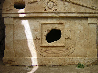
Right next to the beach and protected by an unkept, rough wooden fence, I see two splendid examples of vaulted sarcophagi – thoroughly cleaned and restored. The one facing me carries a relief of a galley – a rarity, I am told. The Greek inscription in the frame above states that the tomb belonged to Captain Eudemos, who sailed to Marmara and the Black Sea and had a good reputation. He had honorary citizenship of Chalcedon (today, part of Istanbul). The boat resembles a sponge fishing boat with a relief of Aphrodite on the keel, who is supposed to protect the sailors. There is another inscription next to the framed one saying:

"The ship has entered and anchored in the last port, for not to go out any more
For there is no more benefit from the wind nor from the daylight
After leaving the morning twilight captain Eudemos
Buried there his short-lived ship like a broken wave.


The second sarcophagus is less photogenic but carries a lengthy Greek text without explanation or translation. Such a pity, for it may have revealed interesting details or the reason why it was put in this protected place.

The beach view exceeds my expectations as the entire setting, with the river and the rock formations, is so different from what I have seen in Lycia before. On my left, to the North, I see modern houses and hotels leading to Kemer. Higher up the opposite southern hill lies the ancient Olympos city, quite an idyllic place with an arched rock enhancing the view. I take a break to enjoy the scenery before I trace my steps back on the dirt road.

I remember seeing a signpost pointing across the river towards the Theater, and I walked back to that point. The riverbank is steep and slippery, but I find the path running over boulders carefully laid for a daring visitor like me. On the opposite bank, I dive into the thickets again, hoping to find the Theater - and I do! This Theater from the first half of the 2nd century AD is definitely Roman and resembles the one in Phaselis, but is in much poorer condition, probably due to the earthquake of 141 AD and more so after the quake of 240 AD. Unfortunately, during the Middle Ages, much of the material was removed for other constructions. I enter through a promising vaulted paradox but find very scattered tiers of seats. Amazingly, the archaeologists could identify twenty rows of seats after all, but it helped that the Theater was carved in the bedrock.

I walk on in the general direction of the Harbor when suddenly I see a good-sized limestone sarcophagus above me. The billboard reveals this is the Tomb of Alcestis or Aurelius Artemias and family from the 2nd century AD. The reliefs are worn down, but I recognize a figure of Nike on each of the four corners. The garlands and figures of Eros that stand for the four seasons are better preserved. On the long side, I find Artemis and her husband saying their goodbyes when leaving this world. The short sides are in better condition. One side shows a standing man and a veiled woman, and the other a veiled woman with a mace-bearing figure of Heracles, hence the deduction that the female figure may represent Omphale, but more likely Alcestis.

Reading up on its history, I learned that Olympos was founded in Hellenistic times, and by 100 BC, it was a major city with three votes in the Lycian League. During the 1st century BC, it was home to many pirates who threatened the interests of the Roman Empire, culminating in the conquest by Cilician pirates. Their leader was Zeniketes, who introduced the cult of Mithras exclusively for men, demanding the ritual sacrifice of bulls for the soul to gain redemption and immortality. In 78 BC, the Roman proconsul P. Servilius Vata chased and captured Zeniketes, razing the city to the ground. After the final defeat of the pirates in a significant sea battle by Pompey, the city became Roman, and the land was sold to new settlers. Roman soldiers continued the cult of Mithras, which spread across the entire Empire. In many garrison cities, Mitraea ceremonies developed in which the bull-killing god was worshiped.

In 130 AD, Hadrian visited Olympos and the Granary on the river's south bank probably dates from this time. In the aftermath of the earthquake of 141, it was again Opramoas of Rhodiapolis who donated 12,000 denarii "for festivities in honor of Hephaistos and the Emperor." The peak of development was reached during the 2nd and 3rd century AD, for after that, the lower city was sacked by pirates, and the population entirely abandoned Olympos in the 6th century. A true story of conquests and conquerors!

Tuesday, February 26, 2013

Chimera's eternal flames

Driving east from Finike, I'm heading for Chimera and Olympos. I find the car park at the foot of the hillside, next to a small café selling refreshments as mentioned in the Sunflower Guide “Turkish Coast, from Antalya to Demre”, as well as the clean toilets and the booth to buy my entrance ticket.

Chimera, once ornated with a Temple of Hephaistos, the Roman Vulcan, and god of fire, is now known by its Turkish name Yanartaş, meaning “burning mountain”. This is where the famous Bellerophon defeated the Chimera, a mythical fire-breathing being, partly lion, partly goat, partly snake, with the aid of his winged horse Pegasus. The Chimera may have been an important religious place of pilgrimage, dedicated to the blacksmith god – the legend going back to 1200 BC at least. The Chimera is the place where gasses from the entrails of the earth escape through cracks and holes in the rock and spontaneously start burning when in contact with the outside air. It is said that in antiquity the flames were higher and brighter, an ideal beacon for the seafarers. Alexander definitely must have seen this "fire mountain" in the shade of Mount Climax where the waves bowed to him.

Once again, I am the first visitor of the day. Originally, I planned to visit Olympos first and walk up to the Chimera from there, but I think it is wiser to do the climbing before the heat of the day picks up. According to my Sunflower Guide, the trip should take me between 20 and 30 minutes, at first ascending over a track and then over a stepped, well-maintained footpath through pine forests, following the red and white flashes of the Lycian Way. This information is entirely correct. The Lycian Way runs over a distance of more than 500 kilometers all across Lycia. It is comforting to know that this is not an isolated trail and I am glad I took my walking stick to help me up the high steps.

It is a rather strenuous climb and in between my huffing and puffing, I take the time to admire the spectacular Lycian landscape while sipping my water. I try to catch the moment with my camera but the outcome is poor. Everything is green, the grass and the weeds, the trees on the hillsides, and the pine trees with shiny needles in the foreground. The sharp rock formations are dull gray and the overall view is hazy because of the moisture in the air left by the rain of these past days and which the sun is trying to burn off. Somehow I am reminded of the sugar rocks around Rio de Janeiro, just as steep but not as green as here, I would say. There are however plenty of flowers, white and yellow ones mainly but also big wild lilac anemones. When I catch my breath again I can even hear the many birds singing in chorus. How wonderful!

A big rock along the trail carries a red-painted message “400 m” and I wonder what it means. Have I climbed to a height of 400 meters, have I walked 400 meters of the trail, or it is still 400 meters to the first flames? It surely has something to do with the Lycian Way running over this path, but that does not solve this enigma. Well, whatever. I scramble and groan my way further upwards and quite suddenly I reach an open rock space where I see the first flames. I don’t remember what I had in mind but the flames are definitively brighter and bigger than I expected. Strange things in the landscape, that’s for sure!

Shooting my pictures, I am amazed to see how clearly the flames are burning with a soft hissing sound and I even notice a faint smell of gas. At times there are clusters of two or three holes next to each other with flames licking the blackened rock around them. Turning around and to my left now below the flames, I see the ruins of a Byzantine church that must be standing on top of the ancient temple dedicated to Hephaistos. In fact, all I can see are the walls and cupolas still carrying clear traces of paint, but the building is mostly buried in the debris and I cannot find any indication of Roman or Greek architecture. Around the lowest fire, there are some loose carved blocks lying around that may refer to the altar that once stood in front of the Temple of Hephaistos. Who knows?

By now more visitors are reaching the flames. Time for me to turn around! Going down is much easier although I have to move with care as the steps are higher than you would think. Back at the parking space, I wonder if I could have some tea. This is Turkey after all, isn’t it? Yes, I can if I can wait that is because they just started the fire. I look at a kind of wood-burning stove with a high stovepipe and three (tea?) pots hanging from the hooks around it. A strange contraption that I don’t try to figure out. I settle for ice cream instead.

Wednesday, February 20, 2013

Mount Nemrud, as close as you can come to the gods

The road to getting there is a unique experience as tension and expectations are building up all along the way!

As I'm approaching Kâhta in south-eastern Turkey,  I first glance at the mountains topped by the perfect conically shaped Tomb of Mount Nemrud. I have no idea what to expect, for I only know the pictures of the colossal heads from many a travel magazine. Kâhta isn't much; a few hotels and car rental companies - sum it up. Yet it's the last town of any significance before reaching my destination, Mount Nemrud. From here onward, it is impossible to travel by bus, and I have to board one of the smaller vans. This is where the actual climb starts, a winding dirt road with short stretches of asphalt. I pass through settlements of about a dozen houses amidst generally bleached land. Higher up from one of the hilltops, I view the immense surrounding landscape stamped by the Euphrates River, which, because of the many dams built for irrigation purposes, looks as wide as a succession of lakes. Occasionally I pass patches of cultivated land fed by a scarce mountain stream. I don't see a single soul, although the houses seem occupied.

When the van stops, I appear to be in a place called Karakuş, i.e., a kind of tumulus framed by two columns with an eagle on top keeping watch. This is the Tomb of King Mithridates II (124-87 BC). In the back of the tumulus, I discover another set of two columns that were once topped by lions. Halfway in between stands a lonely column carrying a relief of King Mithridates holding the hand of his wife, Laodike. Mithridates ruled over the Commagene Empire, just like Antiochus I, the builder of Nemrud, and his tomb is a discreet promise of what lies ahead. Since this is the first time I'm confronted with the Commagene, I  need to dig back into history.

This region was included in the Persian Empire from the 6th century BC until Alexander the Great's victory at Issus in 333 BC. After he died in 323 BC, this part of his empire fell to Seleucos I Nikator (see: In the wake of Seleucos Nicator I). When, in turn, the Seleucid Empire was conquered by the Romans in 189 BC, it didn't take long for new kingdoms to emerge. Commagene, one of the successors of the Seleucids, occupied the area between the Taurus Mountains and the Euphrates River. The kingdom of Commagene was founded in 162 BC. In 109 BC, Mithridates Kalinikos I, who ruled over the Persians and Macedonians (descendants of Alexander the Great), joined both countries into a mighty buffer zone between the Parthians in the east and the Romans in the west. The peak of this kingdom was reached under Antiochus I Epiphanes (69-36 BC), the successor of Mithridates and thus the builder of Nemrud. Eventually, in 72 AD, the territory was annexed by Emperor Vespasian to the Roman province of Syria.

A tributary of the Euphrates, the Cendere, is a wide but short watercourse that lies across my road. It has been bridged on its narrowest point. This is not just any bridge but one that dates back to the 2nd century AD, built by the Roman Emperor Septimius Severus. I am allowed to walk across the bridge on foot, a hugely gratifying experience! Imagine threading over a 2,000-year-old bridge. It makes you wonder about its role and purpose in this isolated and steaming hot place – it definitely commands high respect for the builders as far as I'm concerned.

The van drives on for another hour to stop at an idyllic mountain terrace with eating facilities situated amidst apple orchards. The view is superb, and I have no idea how much further or higher I'll have to climb, for it already feels like I have reached the mountain range. The black ribbon of our road winds away in the landscape and disappears beyond the horizon into the unknown. Picking up the drive again, the van rattles over occasional brick-paved or totally unpaved roads. On a steep hill, it suddenly comes to a final halt; this is the end. The last stretch has to be climbed on foot, although I still fail to see the colossal heads that must be out there somewhere. After half an hour of huffing and puffing, scrambling over high steps up the rough slope, I finally reach the top at 7,700 feet.

I arrived at the very foot of a clean conical heap of loose gravel, approximately 50 meters high and 150 meters in diameter, piled up on top of the existing mountain, presumably covering the Tomb of Antiochus. In fact, this cone has been built with the material left over from carving the giant statues and many friezes that I'm about to see.


On the east and west sides, I discover the enormous statues and heads I recognize from the pictures. On the east side, a row of styled sitting figures that originally stood 8-10 meters high is facing me, their decapitated heads resting at their respective feet. From left to right, I'm identifying Apollo (equaling Mithra, Helios, Hermes); Tyche, Commagene's goddess of fertility; Zeus (equaling Ahura Mazda); Antiochus in person (why settle for less!), and Heracles (equaling Artagnes or Ares). These are, in fact, all the most important Persian and Greek gods of Antiochus' empire, and it is generally accepted that he attempted to unify his multi-ethnic kingdom to secure his authority. On either side of this group of statues stands an eagle, the symbol of freedom. Next to it is a lion, a symbol of courage. An identical group of figures stands on the western side, all decapitated as well, but catching the full sunlight this time of day. Whereas the statues on the eastern side are decorated with Asian attributes, those on the western side show European accessories – a sign of Antiochus' goal of joining the East and West.

It is unclear whether the statues have suffered from the frequent earthquakes or if some odd archaeologist tried to blow up the pile of gravel to find the still-eluding tomb of Antiochus I. The path connecting the east and west sides runs along the northern slope, where several reliefs with unrecognizable artwork have been aligned. It appears they were fitted in the ground with a kind of wedge, an intriguing feature. On the west side, a few original reliefs are still in situ, representing King Antiochus in person together with Apollo on one, Zeus on the other, and finally, Heracles on the next one.

What a place, however, for a sanctuary! It's hard to come any closer to the gods, I think. The view from up here beats everything I have ever seen and surpasses any possible description. It is too grand, too wide, and too panoramic to comprehend. I take pictures, perfectly realizing that the eye sees far more than my camera, but the temptation is far too big. I'm genuinely standing on top of the world! Who says that's in the Himalayas? I doubt you'll have such a view from there! What a beauty.

The big attraction is visiting these altars by sunrise or sunset. The thought of witnessing the sun peeping above the horizon in the great silence and peace that comes with it must be awe-inspiring and rewarding. Yet, you will not be able to enjoy the exceptional panorama I've been treated to. Besides, to get here before sunrise, you'll have to be on your way before the crack of dawn, and if you want to arrive by sunset, you'll have to face a long, scary, and dangerous drive back in the dark. I'm not sure I would like that.

Saturday, February 16, 2013

More descendants of Alexander the Great in Pakistan?

After publishing my article about the Kalash People (see: The Kalash, a lost tribe of Alexander the Great?), I received a comment making me aware of the Burusho people, also living in northern Pakistan. This asked for some research, of course.


The Burusho or Brusho people live at the foot of the Karakorum Mountains in Northern Pakistan and their language, strangely enough, seems not to be related to any other. They are better known as the Hunza People after the main valley of Hunza where they live but they are also spread over the Nagar and Yasin valleys of Gilgit Baltistan.

Yet, they pretend to be descendants of the Macedonian soldiers that were part of Alexander the Great’s army that crossed the region in 326 BC. Stories like this one still circulate in much of today’s Afghanistan and northern Pakistan, but legend or not, the Burushos or Hunzas believe that it was a Macedonian soldier who founded the town of Baltit. Genetic evidence, however, reveals only a 2% component – very much like that of the Kalash people; they also have some East Asian genetics suggesting some ancestry from north of the Himalayas.  DNA research, on the other hand, shows that the Hunzas share ancestry with the speakers of Pamir languages (Afghans) and the Sinti (Gypsies). The strangest of all assumptions is that they may be related to the lost or imaginary kingdom of Shangri La! Time to tell tales. According to Dr. John Clark who lived among the Hunzas for nearly twenty years, the Burushos do not count their age only in calendar years but also in a personal estimation of wisdom, making them often reach ages of above one hundred!

It is obvious that during his thousands of miles-long marches, Alexander’s men have left many children behind. If you consider that this army counted an average of some forty thousand soldiers, I dare anyone to figure out how many children they generated. These offspring are not mentioned as such in our history books, but their presence obviously is non-negligible. Alexander arranged for 30,000 of such boys to be trained as “Macedonian” soldiers; on average, there must have been at least as many girls also. Basic math makes this total account for one and a half child per capita, but their numbers simply must have been much higher. We will remember that at his Susa wedding, Alexander officially granted a proper dowry to over the 10,000 soldiers in his army who had taken a Persian wife. No account exists for the many concubines or occasional affairs that must have occurred all along the road, producing, even more, future soldiers to swell the ranks of his army.

[picture from Wikipedia]

The valleys of Gilgit Baltistan are still too remote at present for serious scientific research, and I personally feel too insecure as well. We are already struggling with Alexander’s heritage in Central Asia and Pakistan is definitely no exception. Only time will shed more light on this possible heritage.

Monday, February 11, 2013

Still in the wake of Central Asia

As can be expected, my trip to Uzbekistan (read more under the Label Central Asia) in search of the footsteps of Alexander the Great in Central Asia is still an ongoing matter.

That is the reason why I went to Paris to see the collection of the Musée Guimet, something that has been on my wish list for the past thirty years or so. Guimet is specialized in Asian art, a vast territory, but evidently, I limited my interest to Central Asia, including Afghanistan, Pakistan and a small part of India and China as well. Being in France, all honors and merits go to the French, of course, with men like Joseph Hackin (1923-1937), Jules Barthoux (1926-1928), Dutreuil de Rhings (1890-1895) and Paul Pelliot (1906-1909). It must be said that in the early 20th century, the ruling King of Afghanistan, an art-lover no doubt, approached the French to carry out serious excavations in his country since he didn’t want to lag behind the archaeological finds made in the neighboring countries. It was only when the Soviet Union invaded Afghanistan in 1979 that these rewarding projects were put to a halt (Ai-Khanoum was one of those projects, with the disastrous results we know).

One of the absolute highlights in this Museum are in my eyes the Buddha’s, Bodittsava’s and other statues and stupa decorations from Hadda in Afghanistan which we owe to Jules Barthoux. The faces, postures and clothing of these statues are unmistakably Hellenistic and the true jewel is in my eyes the “Génie aux Herbes”, a spirit holding flowers in his lap. Another precious place is taken by the glassware excavated by Joseph Hackin on the site of Begram in Afghanistan also, with its blue, white and transparent fish-shaped vessels and the colourful painted glass beakers with scenes from Greek mythology and daily life. I had seen some of these items in the travelling exhibition Afghanistan: Hidden Treasures from the National Museum in Kabul a few years ago in Amsterdam, but that was only a selection of items – now here I find a lavish collection.

An entirely different chapter is occupied by the polychrome Chinese terracotta figures from the 7th and 8th century with dancing girls, musicians, girls playing polo on their horses and several terracotta Sogdian merchants with their horses or camels walking straight out of the desert dust. What I didn’t expect though is finding these exceptional Chinese terracotta statues from as early as the second century BC which look more Greek than Chinese - unbelievable!

Any description as detailed as I could make it will fall short of the beautiful artefacts exhibited at the Musée Guimet. A better impression can be obtained by flipping through my pictures on this link: Paris, Musée Guimet.

Saturday, February 9, 2013

Ulpia Serdica, the Roman name for Sofia

What to do when remains from antique cities are found right in the middle of a major modern city? The question is not new and the answer as always is a compromise between extra expenses and the urge to preserve ancient constructions. Sofia, the capital of Bulgaria is no exception.


For several years, archaeologists are excavating the Roman town of Ulpia Serdica, whose remains are located on top of the underground extension plans of Sofia. So far a Roman palace, baths and burial sites have been excavated at the intersection of what is believed two major streets. At least two more Roman palaces are waiting to be uncovered and parts of the Roman fortress and adjacent church from the 4th century have already been excavated and fully reconstructed. We should not forget that this Roman Ulpia Serdica was entirely built above the Thracian city from the first century BC.

The debate here as elsewhere has raged on for years. A major metro station was planned exactly underneath the historical site. At last the authorities have opted to preserve the remains where they are, be it at excessively high costs, of course. An underground museum covering 1.9 ha will be built and with the help of EU money they hope to create a centre for exhibitions and performances that will put Sofia on the map in competition with other major cities like Rome

In my humble opinion this may take quite a while to materialize, if ever they get that far …

Wednesday, February 6, 2013

Foreign Devils on the Silk Road by Peter Hopkirk

I have been fascinated by the cities along the Silk Road following a recent exhibition held in Brussels about the Chinese part and further to my trip through Uzbekistan where I inevitably winded up on its traces. Yet, I didn’t have an overall picture, especially since we generally talk about “The” Silk Road while in reality there are many – although all are intertwined to reach east or west one way or another.

Foreign Devils on the Silk Road” is subtitled “The Search for the Lost Treasures of Central Asia (ISBN 978-0719564482) – how appropriate! In his book, Peter Hopkirk collects and summarizes the handful of expeditions made over less than thirty years. Basically, Central Asia was shared by Tsarist Russia and the British Empire because of their presence in India.

The very first westerner to set out in the inhospitable Desert of Taklamakan was the Swede Sven Hedin, a scientific explorer, fluent in seven languages who visited the area in 1895 and in1899. Although he was neither a historian nor an archaeologist, but a trained geographer and cartographer, his meticulous studies turned out to be very useful for the brave explorers who followed.

Next arrived Aurel Stein, a Hungarian-born orientalist who became a British citizen. He hit a soft spot in my heart because he was fascinated by the campaigns and travels of Alexander the Great, spending much of his early years retracing Alexander’s routes and battlefields, and eventually his legacy in Central Asia. Stein started his fruitful and daring explorations of the Taklamakan Desert in 1900. One his most exciting finds in my eyes is, for instance, the wooden tablets with clay seals with figures of Pallas Athena and other Greek deities, but this is only the tip of the iceberg of his fertile harvest, of course. By the time he returned to Britain, it became clear that an entirely new civilization had evolved in the very heart of Central Asia.

Soon it were the Germans who set out on an expedition in 1904 to be led by Albert Grünwelde. Unfortunately, he fell ill and was replaced by Albert von Le Coq, a most capable man, much to Grünwelde’s dismay as he wanted to reap all the honors. The French were late to show up in Central Asia (1906), simply because they had been busy in Indo-China’s jungle where they discovered the unique site of Angkor. Paul Pelliot was a linguistic genius, speaking thirteen languages including Chinese (which none of his predecessors mastered). This knowledge was highly appreciated by the locals and opened many doors otherwise locked. The Japanese were among the strangest diggers, sending two scholar-monks in 1908 financed by a certain Count Otani in Kyoto. They were generally seen as spies although nothing could be proved. The Russians, in spite of their priority location only made occasional incursions of no consequence. The very last visitors were the Americans in 1923, with the orientalist Langdon Warren who discovered a lost part of the Chinese Wall. By 1925 the free-for-all to take in this meanwhile well-mapped desert was all over, the first hostilities between China and Britain exploded. China closed all doors to foreign visitors.

To make this story complete, Peter Hopkirk has followed the road taken by the vast quantities of colorful wall paintings, gorgeous sculptures, precious manuscripts and other artifacts from the Silk Road. In fact, they are scattered among many different museums worldwide. Hedin’s collection has found a place in the Ethnographical Museum of Stockholm, while Pelliot’s artifacts are exhibited at the Guimet Museum in Paris. Stein’s treasures were generally split between the National Museum in Delhi and the British Museum in London. The German collection gathered by von Le Coq got its own museum in Berlin, unfortunately heavily bombed by the allied during WW2 destroying the biggest fresco’s that had been cemented in its walls. Smaller frescos, other artifacts and manuscripts could luckily be saved and are now part of the largest and most imaginative display at the Dahlem Museum in Berlin. On the third place comes the Japanese collection that originally was kept at Count Otani’s villa, but was later partially sold. A selection of the treasure ended up in Seoul, packed in the storerooms of the National Museum. Another part travelled to Manchuria from where it was probably removed by the Russians in 1955 when they handed this land back to China. Some pieces, however, are on display at the Tokyo National Museum. Finally and as a matter of course, The Hermitage in St Petersburg has its own display of the Silk Road treasures spread over eight rooms.  

It is amazing how much information has been gathered in this relatively small book, for the story is not complete yet. There is a special chapter dedicated to the early discoveries of manuscripts written in previously unknown languages and found accidentally by local treasure hunters. These documents among which fifty-one birch-bark leaves made their way to Calcutta and were found to be written in Sanskrit using the Brahmi alphabet in the 5th century. This made it one of the oldest written works to survive anywhere. A vivid interest from western scholars set a machinery in motion to find more of such manuscripts. There was money to be made and local forgers discovered that they could get away with their loads of faked manuscripts, even inventing unknown characters. To increase their production they didn’t refrain from using block printing. Some orientalists accepted these documents as originals, but Stein was one of the skeptics and he got to the bottom of the story, exposing the mastermind. A good deed that was not fully accepted by those who strongly believed they would be the first to decipher this new “unknown” language. Yet, all the news was not bad, for eventually the long-lost language of Khotanese was discovered.

Today the manuscripts from the Silk Road are divided between the British Library (Chinese, Sogdian, Uighur and Tangut works) and the India Office in London (Tibetan, Sanskrit and Khotanese). The thirteen thousand Chinese manuscripts and books are now neatly stored on the shelves of the British Library, an honorary place I would say.

After reading about this history of the Silk Road, the Taklamakan Desert and Central Asia, in general, it is hard not to be interested in digging any further. It certainly has sharpened my interest!

Saturday, February 2, 2013

From Thutmosis III to Alexander III

History, as it is generally taught in our schooling system, is a mere succession of names and dates, of kings and battlefields, of peace treaties and foreign invasions. It usually starts with rough sketches of prehistoric times, to be soon followed by the Sumerians, Babylonians, Egyptians, Greeks, and Romans, till after the separation of east and west we soon get to the Middle Ages. In these dull lessons, each civilization was compartmented, one making place for the next. This misconception, unfortunately, is one that we carry along for the rest of our life. How wrong this is!

It is not so long ago that I discovered that rather than a vertical list of events, history is an exciting world spreading horizontally, overlapping east and west where each kingdom ultimately "borrowed" and used knowledge from their enemies in newly conquered territories. Since then, I keep marveling at this ever expanding ancient world.

Oliver Stone in his Alexander movie puts a remarkable idea in the mouth of Aristotle: that of looking at the Middle (Mediterranean) Sea as a frog pond. I think this is a fairly truthful picture, as “frogs” from all the harbors and cities bordering the Mediterranean jumped back and forth over the centuries. We have no idea of the intense traffic of ships ferrying goods (and ideas) from one place to the next, or sailing up main rivers to reach further inland destinations. It was not all pillage and warfare, there definitely was commerce, the very keystone of a flourishing economy. This is something every king or citizen understood and worked for.


It so happened that I was confronted with Thutmosis III, pharaoh of Egypt from 1479 BC to 1425 BC reigning partially in the shadow of his co-regent and aunt, the exceptional Queen Hatshepsut. As strange as it may seem and although Thutmosis III lived more than a thousand years before Alexander the Great, he got my undivided attention when I learned about the new equipment he used in his army and the talent he developed in his conquests. Immediately, I made the link with Alexander who is never far away in my thoughts anyway.

There is the case of the Battle of Megiddo when Thutmosis fights against rebellious Canaanites led by the King of Kadesh. Here, Thutmosis used the composite bow for the first time and he was able to push the Canaanites back inside the city walls. As a consequence, Megiddo was kept under siege for seven months and when the city finally surrendered, Thutmosis had to solve another problem: how to govern a city so far away from his native Egypt. He decided to take with him all the children of the noblemen in order to give them a proper Egyptian education; they would eventually return to their hometowns as true Egyptians. By doing so, he obviously kept the elders and nobles under control. Inevitably this action reminded me of Alexander who created an army of 30,000 Persian boys, sons of prominent leaders and members of the local nobility, to be drilled and educated the Macedonian way. His goal was the same as that of Thutmosis: to control the influential class of natives and using the young men to his own benefit. Maybe that was a generally accepted procedure but even in antiquity historians presented Alexander’s action as an exceptional move and even as an innovation.

[Click here to read two interesting article published in Ancient History about this battle of Thutmosis and the site of Megggido]

The other fact that made me link Thutmosis to Alexander was Thutmosis’ attack on Mitanni after having taken control of Syria. The pharaoh sailed from Egypt to Byblos where he disassembled his boats and took them with him knowing that he had to cross the Euphrates River later on. At the banks of the river, he had his ships reassembled to put his men and horses across. Amazingly enough, the pharaoh took the Mitannian King entirely by surprise for he was not expecting an invasion at all. Mitanni had no defense line or walls, they only could try to stop the Egyptians from crossing the Euphrates – a futile attempt as it turned out. This story reminded me of course of Alexander crossing the many rivers in India where he regularly dismantled and reassembled his ships. I thought this was a novelty but now I hear that the Egyptians used the same technique tens of centuries earlier! Of course, this doesn’t make Alexander less of a genius in my eyes for after all there is still a difference between knowing the technique and implementing it. Maybe the very idea had been forgotten meanwhile?

So much of the knowledge from the ancients has been lost over the centuries that we will never know how much they really knew and how much information was exchanged between the different civilizations.

[Picture of Thutmosis III at the Temple of Karnak]

Wednesday, January 30, 2013

Lost World of the Golden King by Frank Holt

Lost World of the Golden King, In Search of ancient Afghanistan by Frank Holt (ISBN 978-0-520-27342-9), is the latest book by this author, who has an unparalleled knowledge of Bactria, a country often neglected by and unfamiliar to most historians.

I totally enjoyed his earlier books: Into the Land of Bones, Alexander the Great and Bactria and Alexander the Great and the Mystery of the Elephant Medallions, as no one knows Bactria more intimately than Frank Holt. He was my mental guide and support source when I visited Uzbekistan (see several articles under the label: Central Asia), so I couldn’t skip reading this latest update of his.

As always, his work is exact and consistent. After Alexander’s conquests in 329-327 BC, the country kept many of its invested Greek influences, eventually giving birth to the Graeco-Bactrian kingdom, followed by the Indo-Bactrian rule. However, after repeated and devastating attacks by its nomadic neighbors, the empire of “a thousand cities” vanished, and from the tenth century onward, only the name of Bactria survived. We had to wait till the eighteenth century when a Greek coin was unearthed, and the first explorers started their search.

Frank Holt follows them step by step, all through the 18th and 19th centuries, analyzing their assessments and holding their conclusions against today’s still sparse knowledge about the Bactrian Kingdom. Not all the coins carry an inscription with the name of their Basileus, and those who do so don’t specify if we are looking at Eucratides I or II, Demetrius I or II, or Diodotus I or II, while on the other hand, we still have no way to put them conclusively in their correct chronology. The studies of these earlier explorers have merit, of course, but archaeology has evolved since then, new techniques have been applied, and the fundamental research of numismatic evidence has progressed.

Meanwhile, one of the “thousand cities” was located and excavated extensively by Paul Bernard (1964-1978) till modern wars put everything on hold and destroyed his painstaking work. By now, Ai-Khanoum, at the far northern border of today’s Afghanistan, has made headlines, and most of his precious finds have found shelter inside the walls of several museums (see the exclusive and still traveling exhibition, Afghan Gold Treasure)

Frank Holt uses the excavation results and artifacts from Ai-Khanoum to reconstruct as much as possible of Bactria, whose most famous king was Eucratides. His huge golden “Eucratidion” was the very first coin that rose from Bactria’s ashes. Sporadic texts and inscriptions and the various hoards add further information and raise more questions.

The reader will get a fresh look at Bactria, its kings, and its heritage. Besides a whole chapter about the mining and minting techniques, including the knowledge involved, Frank Holt’s book offers a wealth of information about every possible aspect of life after the campaign of Alexander the Great in the furthest northeastern corner of his empire.  

Sunday, January 27, 2013

Latest find at Stratonikeia, Turkey

Turkey is an everlasting source of new discoveries. The country has such a rich past, of which only a few tourists seem to be aware, and then only with names like Ephesos, Miletus, Priene, and maybe Didyma or Halicarnassus, modern Bodrum. But there is so much more with constant new finds, some more spectacular than others. 

A while ago, I wrote about the amazing sarcophagus that was unearthed in the area of Milas (see: Sensational Archaeological find near Milas), and today it is the turn of Stratonikeia, roughly halfway between Milas and Muğla. Stratonikeia was part of Caria, a generally unknown kingdom, although in its heyday it was ruled by none less than King Mausolos, the builder of the Mausoleum of Halicarnassus - one of the Seven Wonders of the World.

During their seventeen-month excavations, archaeologists have uncovered part of a road flanked by columns that led to the gate in the city walls. These walls are estimated to be 3,6 kilometres long and for now, a stretch of 400 meters has been exposed. It seems that the walls were restored by King Mausolos some 2,400 years ago.

[Photo: AA, from Today's Zaman]

Main find in the area was this huge 2,000-year-old Hellenistic bust of a king that stood one and a half meters high and is two metres wide, showing features of a bull’s head and a goddess – signs of wealth and power. Previously, a chariot had been discovered, as well as a 1,500-year-old Byzantine mosaic. All in all, 460 artifacts, both Roman and Byzantine, have been collected by the archaeological team and are now transferred to the nearby Museum of Muğla.

After full restoration, the wall will be accessible to visitors, and so will the Museum once the finds have been treated appropriately.

For a great overview of Stratonikeia, please refer to this link at Peter Sommer Travels.