Monday, October 31, 2016

Locating Alexandria Nicea and Alexandria Bucephalus

For what it is worth, a monument in honor of Alexander has been erected in today’s Pakistan at the very spot where he and his army camped before his Battle of the Hydaspes. The exact location for this battle seems to have been pinpointed at Mong Village in the Punjab. According to local traditions, it was built on top of Alexandria Nicaea, a city founded by Alexander to celebrate his victory over Porus in 326 BC.


The Greek Ambassador in Pakistan officially laid the first stone of this monument on 24 May 1997, and the building was set in a mixture of Greek and modern styles. The intention was a good one, of course, but construction has reached a standstill, and today all doors are locked. The governments of Pakistan and Greece have abandoned the project, which could have attracted many tourists. The few visitors, if any, can no longer genuinely enjoy the decaying map of Alexander’s conquests at the center of the roof. Alexander certainly deserves better!

So far, archaeological excavations have yet to confirm the exact location of Nicaea, and the search is made particularly difficult because the landscape has changed over the centuries. Sir Aurel Stein, who closely explored the area at the beginning of the 20th century, believed that Alexander would have crossed the Hydaspes River near modern Bhera, close to the village of Mong. His conclusion is based on his analysis of the topography, the river orientation, and other natural features like the nearby salt cliffs, which all match the descriptions from antiquity. What may carry more weight is the fact that the people of Mong claim that theirs is indeed the Hellenistic city of Nicaea. More often than not, the legend may be closer to reality than we like to admit.


Not far from Mong, but on the other side of the Hydaspes (Jhelum) River, the city of Phalia also has a legend of its own as their residents claim that the city is named Alexandria Bucephala after Bucephalus, Alexander’s horse, who died here around the time Alexander was fighting Porus. They even erected a statue in honor of Alexander’s faithful mount in the middle of their city. It is sad to hear that the search for Bucephalus’ grave has been given up and seems no longer to be of interest to the local population.

All in all, the above statements about Alexandria Nicaea and Alexandria Bucephalus locations are far too vague to be truly conclusive. Still, at least the achievements of Alexander and the memory of his dear Bucephalus have not been forgotten – this despite his short-lived passage through Punjab 2,500 years ago.

Friday, October 28, 2016

Unique inscription found at ancient Teos

Teos is one of those little shrines that is often overlooked by the casual tourist, but that deserves a place among the many interesting remains spread all over Turkey. Today, Teos is a quiet fishermen’s village some 50 kilometers from Izmir.

Herodotus tells us that the site of Teos is located in the mildest places on earth, and the amazing fact is that it has provided most of the Anatolian inscriptions (about 400) giving a very detailed picture of daily life during Hellenistic and Roman rule.

Excavations started again in 2010 and the exciting news is that a 2,200 years-old inscription has been uncovered, being the most comprehensive rental agreement in history. It tells us how students of the local gymnasium between 20 and 30 years of age, the so-called Neos, received a substantial inheritance from one of the city’s inhabitants. This person donated his land to the Neos, including all structures, the slaves, and its sacred altar. In order to get some income and to cover the expenses for exploiting the parcel, the Neos rented the land. It was exempt from taxes because the parcel was accepted as being “sacred”. The agreement gives the names of the renter as well as that of his father. In order to be valid, the agreement had to be endorsed by a guarantor and had to be signed by six witnesses. In the present case, three of the witnesses happened to be top administrators of Teos.

This is the only inscription found so far that states the structure of the gymnasium and the fact that the Neos were allowed to own property. Half of this inscription is about the punishments the renter would face if he does not pay his annual rent, does not maintain the buildings, or does not properly manage the land. The Neos also vowed to inspect their property at least once a year.

It is interesting to note that these Neos served as civil servants in politics and in assemblies.

During the 3rd century BC, many important philosophers, poets, musicians, and singers formed a Dionysus Union attracting people like Anacreon, Epicurus, and Antimachus.

Monday, October 24, 2016

Tracking Alexander from Tyre to the Euphrates

When reading any of the Alexander histories, the routes he followed seem to be clear-cut and leave no room for any doubt at all – that is until we actually try to walk in his steps with a map in hand. Many stretches are quite obscure while others are, let’s say, not too obvious. Historians have a tendency to stick to the facts and when nothing noteworthy is happening between point A and point Z, they simply skip every step or stop in between. This is the case when Alexander leaves Tyre for Thapsacus and Arrian simply states that he marches “inland”; a straightforward route until you try to figure it out.

In antiquity, the traveler would generally follow rivers, skirt mountains and deserts, look for arable lands able to provide enough food, and spot wells for drinking water when there is no river on the way. When this is not possible, one has to be inventive. A good example of such creativity is, for instance, when Alexander has his fleet accompanying him along the desert of the Sinai; another one when he returns from Egypt to Tyre and where his army had widely depleted the rare agricultural provisions on their way south a few months earlier and he made use of his fleet once again.

From Tyre, scholars are generally torn between two possible routes leading the army inland. The first would retrace Alexander’s steps north to near Antioch-on-the Orontes along the coastline and from there turn east towards the Euphrates as Cyrus the Younger and Crassus had done, using the fleet to support his provisions. The other possible road, which I prefer because the region was more fertile in antiquity, runs east to Damascus and from there north to Homs, Hama, Apamea, and Aleppo. Or, after all, Alexander may have used a combination of both routes – why not?

Damascus is incontestably the oldest inhabited city in the world and against all odds, I am looking for traces of Alexander but find none. That is not surprising since he only passed through the city in 331 BC; there was no siege or resistance apparently. In fact, there is nothing left that could refer to Hellenistic times, as all traces generally have been erased and supplanted by Roman constructions anyway. The Romans, however, used Greek and Aramaic foundations when they laid-out Damascus, covering an area of approximately 1,500 x 750 meters, inside its protective walls. Damascus counted seven city gates, but only the Bab Sharqi on the east side has survived. This city has been discussed in detail in my earlier blog, Damascus after Alexander.

Even the modern road north from Damascus skirts the eastern flanks of the Lebanon Mountains. The countryside looks uninviting and a pretty barren stretch of some 200 kilometers that Alexander must have tackled stubbornly as always, although the land may have been more fertile in his days.

Beyond Homs, he must have aimed for Hama which lies on the Orontes River and is today one of the largest cities in Syria after Aleppo, Damascus and Homs and an obvious stop for anyone traveling between Damascus and Aleppo. Under Hellenistic rule, the city prospered since it laid on the trade routes between Greece and Asia. Hama is best known for its spectacular large wooden waterwheels – a Roman/Byzantine invention so ingenious that you have to see them in order to fully grasp their significance (see: Hama and its ingenious norias). Known under their Arabian name as norias, their earliest traces are found in a mosaic dating from 469 AD but they may have been used earlier on.

From Hama, the modern road heads straight for Aleppo without being hampered by the desert but Alexander must have stayed closer to the floodplains of the fertile Orontes River for the first stretch of his route at least and would, inevitably, have come to Apamea (see: Apamea, heritage of Alexander).

Leaving Apamea, Alexander must have veered to the northeast across a mostly desert landscape to reach Aleppo, almost one hundred kilometers away. It is not impossible that previously to his march, he organized water depots along the way.

The modern city of Aleppo has been built right on top of its antique remains, meaning that there is very little to see from when Alexander was here in 331 BC. His successor, Seleucos called it Beroea in memory of the city by the same name in Macedonia. It became the center of gravity of the Hellenistic colonization till it was conquered as the rest of Syria by Pompey in 64 BC.

The most striking feature in Aleppo is unmistakably its Citadel situated at the center of the old city that was surrounded by a five kilometres-long wall counting seven entrance gates. To my knowledge, no Greek/Hellenistic remains have been uncovered although excavations have reached the layers of the neo-Hittite period. Yet it seems that friezes belonging to a temple dedicated to the god of storm Hadad dating from the third millennium BC have been discovered.

This partially manmade hill that is crowned by the famous Citadel rises some fifty meters above the city and measures respectively 450 and 325 meters across since it has an elliptical shape. Originally the entire hill was covered with large blocks of whitish limestone that were very difficult to climb; some of these slabs are still in situ. The mound is surrounded by a moat, 22 meters deep and 30 meters wide, which has been added in the 12th century. The inside of the Citadel is a town on its own with a hammam, a number of mosques, a palace occupied by the sons of Saladin and even a theater that is still being used. All this is obviously a very far cry from what Alexander may have found, but the panoramic view over the roofs of Aleppo cannot have been too much different, except for the presence of minarets and mosques.

Alexander arrived at Thapsacus by mid-summer 331 BC and had two (pontoon) bridges constructed over the Euphrates which, according to historians was a good 700 meters wide at this spot. There have been endless discussions about the location of this city, which has been placed at Al Raqqa, Dura-Europos and even at Deir-Ezzor further downstream. Based on the facts related by Xenophon and Eratosthenes, however, all evidence points towards Carchemish on the Turkish-Syrian border. It seems that, except for a few towering walls, there is very little left of old Thapsacus because after the construction of yet another dam the river has turned into a lake and the scant remains are nothing more than an island in the middle of the Euphrates. It is so sad to find such a historical place swallowed by the waters after centuries of survival!

It so happened that my first view of the Euphrates River was near Birecik, Turkey, on the road from Gaziantep to Sanliurfa, i.e. about 30 kilometers north of the place that has been identified as Thapsacus. Crossing this majestic, wide, blue and fast flowing river over a modern bridge, confirmed that I was truly entering Mesopotamia, the land between Euphrates and Tigris from my history books. The depiction of this being the Fertile Crescent eludes me, for the land is desolate and barren and the houses on the eastern river bank are nothing more than square colored blocks piled up against a sandy hill.

Based on Darius’ earlier crossing of the Euphrates before the Battle of Issus, it may have taken Alexander five days to move his entire force to the eastern bank. The logistics of such an operation are never discussed in detail, neither here nor at any other major river like the Nile, the Tigris, the Oxus, the Jaxartes or the Indus for that matter, but the operations much have been colossal and terribly well organized!

The modern flow of the Euphrates cannot be compared to what it was in Alexander’s days, mainly because of the many barrages that interfere, but it remains a very rewarding experience to follow the river further downstream along the Lake of al-Assad to Rasaffa, Al-Raqqa, Halabia, Deir Ezzor and finally to Dura-Europos. These basically were all Roman forts at the edge of the empire but most probably were first settled by Seleucos a few decennia earlier. Contemplating the river from among the reed fields in the near silence on an early winter evening was one of my greatest experiences. In the tiny villages in between, time has come to a standstill.

Another memorable moment was at Halabia where I climbed up to the remains of a Roman fort. From this strategic location, I could look up and down the Euphrates beneath me as the soldiers had done some 2,000 years ago. From this vantage point, I was reminded of Alexander when the occasional car crossed the rickety pontoon bridge with a resonating sound in the quiet evening air. History was simply unfolding at my feet! I was wishfully thinking to look for Thapsacus around there. 

Thursday, October 20, 2016

Another look at the exchange of knowledge and goods between East and West

Although China has come closer to us in recent decennia, the country remained isolated for most of its history. Few people realize that in the wake of Alexander’s expansion beyond the heart of Central Asia, an opening was created. After all, in 329 BC he founded the city of Alexandria Eschate (very appropriately being Alexandria the Furthest), the later Khojend in modern Tajikistan.

Yet, even Alexander and his successors were not the first to penetrate into China or Seres as Strabo calls the country. A few years ago, I learned about prehistoric mummies that were found in the Desert of Taklamakan. These were blond-reddish-haired people and their clothing included tartans, a clear hint of Western European origins. This discovery seems to have remained a fact on its own, as I found no hint to link this migration corridor to historians on which Alexander could have relied, but altogether might have known? As so often, it is not because this fact has not been documented that it did not exist. It sounds rather logical that if people were able to move as far east in prehistoric times, to even doubt about Alexander’s knowledge of this route and destination.

Anyway, putting my thoughts about these Western European people on the side, the Greeks in Central Asia were there to stay for the next three centuries following Alexander’s conquest. Seleucos established his empire in that area, which later on was taken over by the Graeco-Bactrian kings who steadily expanded further eastwards. The leader in this expansion certainly was Euthydemus I (230-200 BC), who even went beyond Alexandria Eschate. He may have gone as far as Kashgar in the region of Xinjiang, as reported by Strabo.

Around 130 BC, it is known that embassies of the Han Dynasty went to Central Asia as the Chinese emperor Wudi was interested in the sophisticated civilizations of Ferghana, Bactria, and Parthia. Numerous embassies left every year to these countries and it has been documented that more than ten such missions were dispatched every year to Parthia, Seleucid Syria, Chaldea, and north-western India.

Ensuing contacts followed when the wealthy Romans became interested in the precious silk that was supplied through the Parthians as early as the first century BC, causing a serious outflow of gold. The Roman historian Florus is one of the few to mention the numerous Chinese envoys who visited Augustus (reigned from 27 BC to 14 AD). The expensive land route, by now appropriately known as the Silk Road, was soon to be supplanted by a prosperous maritime route through China-controlled ports in Vietnam, India, and Sri Lanka on one end, and Roman-controlled countries like Egypt and the Nabataean territories.

Much of this period of history was well documented in China, like, for instance, that of a Roman delegation arriving in China by this maritime route in 166 AD but fewer testimonies have survived in our part of the world, and consequently much of this Silk Road sank into oblivion till it was revived by the tales of Marco Polo.

Monday, October 17, 2016

The huge Temple of Hadrian at Cyzicus

Cyzicus was conquered by Alexander and he is said to be responsible for connecting the island to the mainland. One of the main buildings for which the city is known is the huge amphitheater with a diameter of 150 meters built by the Romans in the third century BC. It was intersected by a stream, making it particularly fit for naval battles – the only one of its kind in Turkey that has survived until 1444 when thirty-one of its immense columns were still in place.


Recent excavations are centered around the huge temple built by Hadrian, which is 161 meters long! It ranges among the largest temples in Anatolia, but repeated earthquakes have damaged the building considerably. At present, archaeologists try to determine the full measurements of the temple and the remains of its superstructure. Over the centuries, unfortunately, the marble of the temple has been fueling many lime kilns and during the Middle-Ages the area was used as a cemetery.

So far, however, many of the temple’s construction elements have been recovered, like marble roof tiles of 105x85 cm, marble gutters with lion heads, columns of 2.25 meters high, the head of an unspecified king, a large Roman capital measuring 1.9 meters in diameter, 2.5 meters high and weighing some 20 tons, and more. Nearby a tomb with inscriptions has been uncovered containing the remains of 10 people among their grave gifts, as well as two lime kilns.

This all sounds very promising and I am looking forward to the results of the latest excavations!

Thursday, October 13, 2016

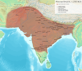
Transition between two great rulers, Chandragupta and Asoka

Chandragupta’s death did not mean the end of the Mauryan Empire, which was to flourish for another four centuries. The most famous ruler was to be his grandson, Asoka, but we cannot ignore the binding role played by his son Bindusara.

[Maurya Empire at its maximum extent]

Bindusara came to the throne in 297 BC, six years after the death of Seleucos. Still, the friendly relations between the Seleucid and Mauryan empires were not interrupted. In 280 BC, Seleucos I was replaced by his son Antiochus I while Megasthenes, his ambassador at the Mauryan court, was replaced by Deimachos. Unfortunately, very few of the new envoy’s records have survived.

There are some speculations that Bindusara’s mother might have been Greek or even Macedonian because his father had made a marriage alliance with Seleucos. Yet there is no hard proof for this theory.

There is, however, an exciting anecdote worth to be mentioned about the relationship between Bindusara and Antiochus, whether it is true or not. Nothing being sweeter than figs, Bindusara apparently begged Antiochus to send him some figs and, while he was at it, some raisin wine as well; he added that he would like him to buy and send him a professor. The irony of the situation cannot have escaped Antiochus, who sent him the figs and the wine but told Bindusara that he could not oblige him with his last wish since it was unlawful for Greeks to sell a professor.

Otherwise, nothing much has been recorded about the reign of Bindusara. He seems to have followed his father’s footsteps and worked on consolidating his empire rather than expanding India further. It also transpires that Chanakya, the famous and highly competent minister of Chandragupta, continued to serve his son with the same dedication.

It is certain, however, that Bindusara maintained peace during his 25 years of kingship and managed to keep the empire together for his son, Asoka. He died in 272 BC at the age of 48.

All these events, it should be said, evolved at a time when the wars of succession for Alexander’s Empire finally settled down.

Monday, October 10, 2016

The Battle of Eurymedon

The Battle of Eurymedon is quite a revelation, for I never heard of it before. I drove along this river on my way from Aspendos to Selge, not knowing that an important fight had taken place here about one hundred years before Alexander marched through this area (see: Selge welcomed Alexander).

After all, my lack of information may not be so surprising as this battle occurred near the end of the Delian League. This was an alliance of various Greek poleis that took shape shortly after the Persian invasion of 480-479 BC and ended at the same time the Peloponnesian War did in 404 BC and which was mainly fought between Athens and Sparta.

The Delian League obviously takes its name from the island of Delos, where the league’s treasury was kept and where the members met on regular set occasions. It is common knowledge that this league was created to take revenge for the Persian invasion of Greece. Still, it also aimed to liberate all the Greeks under Persian domination and guarantee the freedom of the Greek cities.
  

Towards the end of the Delian League, the Athenian statesman Cimon was instrumental in creating Athens’ powerful maritime empire. He was the hero of his time after fighting at the Battle of Salamis. It was a small step to be promoted Admiral and lead the fleet of the Delian League with 300 triremes, of which 200 were Athenian. This was in 466 BC when he set out along the Carian and Lycian coasts to expel the Persian garrisons and to bring those liberated cities into the league.

After taking Phaselishe set sail for the Eurymedon River, today’s Köprülü River, to annihilate the 200 ships' strong Phoenician fleet that had occupied the river together with several reinforcements from Cyprus. This was Cimon’s most famous battle, and his victory here proved to be definitive. In this phase, he seems to be a precursor of Alexander!

It would have been nice to know where exactly this battle took place, although the mouth of the river near Aspendos sounds to be favorite.

Thursday, October 6, 2016

Perge’s Western Street reveals more statues

Each time I visit the Archaeological Museum of Antalya, there is something new to be seen. The Museum is expanding continually and just recently an entirely new section centered around the Western Street of Perge has been added.


The wealth of Perge seems to be endless and the latest discovery of a more than life-size statue of Emperor Caracalla has made the headlines. Caracalla, whose full name was Marcus Aurelius Antoninus, seems to have been very fond of Perge and his 2.2 meters high statue is the largest ever found. It stood at the junction of the Western Street and the Northern Bath to enhance the so-called Caracalla Fountain. The emperor only misses his right hand that is supposed to have held an unknown object above his head. He still wears the insignia of the eagle and the Medusa head; his head was crowned with a Corona Civica, a series of oak leaves woven into a crown.

Other finds include statues of Aphrodite, Tyche, Nemesis, Asclepius, Helios and Selene, beside those of a snake, a horse, a man and a woman.

Excavations at Perge have been ongoing for the past 70 years now and it is quite amazing that the flow of discoveries is still so enticing. 

Saturday, October 1, 2016

Alexander in hot pursuit of Darius

Talking or writing about Alexander is generally centered on his major battles with a few rare exceptions for his generalship. What keeps fascinating me, however, are all the in-between stories that link his major achievements. At times, it feels like reading between the lines while in fact, no moment of his life was ever dull or uneventful.

One such less-known but extremely exciting period in Alexander’s life is his chase after Darius. Fleeing from the Battle of Gaugamela, the Persian King had elected residence at Ecbatana, the Achaemenid summer capital. When Alexander was at about three days march from that city he learned that Darius had left five days before heading for Bactria, taking with him the available treasure of 7,000 talents and a force of 6,000 infantry and 3,000 cavalry. Before starting his merciless pursuit, Alexander had to settle a few pressing matters like dismissing the Greek allied contingent and the Thessalian cavalry that had finished playing its role in the League War. He also instructed Parmenion to transfer the treasuries from Persepolis and Pasargadae to Ecbatana.

Once that was taken care of, Alexander elected his Companions and the mercenary Cavalry, as well as the advanced scouts, the Macedonian heavy infantry, the archers, and the Agrianes to accompany him on this manhunt. Yet his advance was so rapid that many of them dropped out as they were unable to keep up the high pace; many horses were also worked to death which makes me wonder about the number of horses he took as spare. But everything and everybody had to yield to Alexander’s determination and he reached Rhagae in eleven days, a distance of some 390 km if he took the shortest route via Qazvin.

On the way, Alexander met many of Darius’ soldiers who had deserted and either returned to their homes or surrendered to him. Darius had passed Rhagae a while ago and since Alexander could not catch up with him at this stage, he gave his troops a five days rest. I don’t know much about horses but I am aware that they cannot gallop for an entire day and also that they need a rest after about four days of continuous riding. The break evidently was not a luxury stop but a mere requirement if he wanted to continue.

From Rhagae (modern Rey) it would have taken Alexander a full day to reach the (South) Caspian Gates according to Arrian, but Donald Engels (see: Alexander the Great and the Logistics of the Macedonian Army) says that he stopped short of the gates proper. He is certain that Alexander chose for Airan Kief (modern Eyvanekey), some 13 km before the gates because the nearby village of Aradan provided the only source of fresh water for his men and horses. His light infantry must have marched all night long till noon the next day, taking advantage of the long daylight hours of summer. At Aradan, Alexander met two important Persian leaders who had deserted their king. They reported that Darius had been seized and arrested by his own commander of cavalry Nabarzanes, supported by Bessus, satrap of Bactria, and Barsaentes, satrap of Arachosia and Drangiana. The news rekindled Alexander’s resolution and he was in the saddle again, this time only escorted by his Companions, the advanced scouts, and a picked body of his toughest infantry. The remaining part of the army was put under Craterus’ command and was to follow on at their own pace. Alexander traveled extremely light; his men only carried their weapons and rations for two days.

They galloped all through the night till noon the next day when they took a brief rest. Soon, they all mounted again for a second all-night march, and at first daylight, they reached the camp mentioned by one of the defectors Alexander had met a few days earlier. The place, probably southwest of Samnan was deserted, the enemy had moved on. The locals confirmed the defector’s story. They also mentioned that Darius had been put in a covered wagon and that Bessus, since he was related to Darius, had proclaimed himself to be the new king.

Without any further delay, Alexander threw himself again in this hot pursuit. His men and their horses were very much exhausted by the demanding marches, but Alexander drove them on nonetheless. I wonder how many times he and his men had to change horses to keep up this high pace. After yet another night and morning march, they reached a village where Darius and his capturers had stayed the previous day. His advanced intelligence informed Alexander that there was a shortcut which unlike the main road from Samnan to Ahuvan avoided the mountain pass; it ran however through uninhabited territory and was totally lacking water. This was not going to stop Alexander, of course, and he ordered the locals to guide him through the stretch of desert.

Being aware that his pace was beyond that of his infantry, Alexander decided to dismount some 500 cavalrymen and replaced them with the toughest and fittest officers of his infantry and other units. They were to keep their own arms and equipment. The remainder of his troops were to follow the road Bessus and his followers had taken.

Alexander set off at dusk, riding through the desert at raging speed covering some 68 km overnight, and finally caught up with the Persians near Damghan at dawn. Most were struggling along unarmed and fled as soon as they saw that Alexander in person was on their tail, a few attempted to fight but soon gave up since any resistance was useless. Bessus and his friends were not inclined to abandon Darius so quickly, but when Alexander was nearly on top of them Nabarzanes and Barsaentes struck him down without any reverence and made their escape. Darius died shortly afterward.

This is the pursuit based mainly on Arrian as Curtius spent more ink describing the corruption and conniving at Darius’ court. Curtius also provides more details about the murder of Darius and how the wagon with his body was found off the main road. A Macedonian, driven by thirst stopped at the nearby river where he found the wagon with the wounded horses still harnessed. Wondering why the animals had been stabbed he came closer and heard the groans of a dying man who turned out to be the King of Persia. It remains uncertain whether Alexander found him still alive or not. In any case, he is said to have shed many tears, taking off his own cloak to cover the body of Darius and ordering it to be taken to Persepolis for a proper burial. 

The Macedonians had covered almost 350 km in six days over difficult desert terrain, meaning that they rode at an average speed of 53 km a day in hot mid-summer temperatures through a country that was largely desert. Much of the riding was done at night and the horses could easily trip over loose rocks and step into unavoidable pits, for how much visibility was there if any? How alert were the riders still after a night and a morning on their unsaddled horses? And look at that last 68-km-run to Damghan which was covered between dusk and dawn! I wonder whether such achievements were ever repeated in history.

It is quite striking to discover that when following Alexander’s pursuit on the map of Iran his route coincides entirely with the modern road linking Tehran to Damghan which runs in the shadow of the Elbruz Mountains along the very edge of the Great Salt Desert or Dasht-i-Kavir. Yet this is also the layout of the ancient Persian Military road and would explain, at least in part, why Alexander was able to move at such a high speed. Unfortunately, the caravanserai that dotted this route every 40 km or so cannot have been of great help for him and his men as I doubt they would have the hundreds of spare horses that were needed. This route was later known as being part of the Silk Road.

Alexander definitely wrote history here, nothing short of any of his celebrated battles or other exploits. This is, however, one of the details often overlooked by historians or by the general Alexander public.