It was so exciting to find this information on Judith Weingarten’s weblog. She always does an excellent job digging out the unthinkable and/or the unexpected. This time she got my undivided attention with her latest article about what is probably the world’s oldest topographical map found in Egypt.
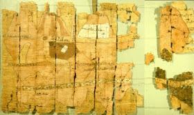
Fragment of Turin map. Photo credit: J. Harrell (via Wikipedia)
This map, which is drawn on a 2m80 long papyrus dates back to 1150 BC and seems to be made by a certain Amennakhte, a scribe who was preparing a quarrying expedition into Egypt’s Eastern Desert. It covers an area of 15 kilometers with the exact location of the quarry from which a grayish-green stone was extracted. In the same area, we can find a gold mine, a small settlement and a temple dedicated to Amon. What makes this map so special is the labeling of the roads and the indication of the distances from one site to the other.
If you want to investigate further on this captivating subject, please click on Judith Weingarten’s weblog for she gives you lots and lots of extra reading material about Egypt’s link with the Red Sea and the harbor of Punt that was only recently located thanks to the wall carvings found in Queen Hatshepsut’s tomb.
A thorough story, as she always manages to tell us. Thank you, Judith!
PS. I can’t help wondering what kind of maps Alexander the Great may have had and used during for campaigns …

No comments:
Post a Comment