Monday, April 29, 2013

Andriake, port of Myra

The site of Andriake lies just across the road from Myra. Driving up, I can’t miss noticing the huge Granary that Hadrian built: 65 meters long by 32 meters wide, a real eye-catcher! It is now marshy land, and it seems nothing much has been done to revive the ruins when I stopped here in the Spring of 2008, but there is enough to entice me.


The road ends at the harbor from where the day tourists are taken by glass-bottom boats to visit the sunken remains on the north side of Kekova Island, which I saw when I sailed the Lycian Coast with Peter Sommer Travels. There is plenty of activity in the local dry docks where seasoned craftsmen are hammering and soldering to get their vessels in shape for the upcoming season. I walk through the sand that the Lycian winds have blown into Andriake harbor over the past centuries, turning it into a swampy area with plenty of waterfowl.

It is easy finding the Granary that Hadrian built here when he visited Myra in 131 AD, although there is no actual path leading to it. After passing the remains of uninspiring walls amidst the bushes, I come to an open space revealing the building on the higher side of the slope. This Granary or Horrea is composed of nine successive rooms that could hold 6,000 cubic meters of grain. Each chamber inside the building is connected to the next, while each has its own wide entrance door to the outside also. There must have been massive locks on these doors, considering the empty space in the side wall where the bolt fitted in. The façade and the partition walls are built with rectangular blocks, but the more sturdy polygonal technique was used for the back wall. Looking closely, I discover the bust of Hadrian and his wife Sabina still in place above the central room. Between the square guardhouses that frame the façade at each end, I also find the reliefs depicting the dreams of the warehouse keeper who served here in the 5th century AD. One of the door lintels shows a relief of shields and spears. Protruding blocks may have held decorative statues between the windows above (that must have provided the necessary ventilation).

Andriake does not look much today, but in antiquity, it was a chief port for Egyptian vessels on their way to Rome. Egypt was the breadbasket of the Roman Empire, so Andriake was a major transshipment port for grain from Alexandria. Like the bay of Iasos in Western Turkey, Andriake harbor could be closed off by a strong chain.

As I walked on, I reached the Agora or Plakoma, surrounded by shops on three sides. What strikes me here is the vast underground cistern half hidden under the large white slabs of the Agora floor where the city stored its fresh water. I see nothing more than a partial pavement half hidden under the low bushes, with gaping openings to the entrails of the cistern. I move around with caution, carefully avoiding these pitfalls.

Some more walls and buildings look like Basilicas and baths, but I need help to figure them out correctly in this overgrown terrain. From my readings, I remember that there must have been statues here to honor Germanicus and his wife Agrippina, who visited Myra in 18 AD, but I’m not sure where.

I leave the rest of the city with its hexagonal tower, its mixture of polygonal and rectangular walls, and the necropolis with Lycian sarcophagi higher up the hillside for what it is. I have seen enough for now.

Saturday, April 20, 2013

Damascus after Alexander

Whether Alexander was in Damascus, either after the Battle of Issus or on his way from Egypt to Gaugamela, is a debate on its own which I will not tackle here. For now, I’m interested in Damascus after the disintegration of Alexander’s Empire and the imprints left by his successors and the Romans afterward.

After Alexander died in 323, the main competitors in Syria BC were Seleucos and Ptolemy, two of his generals who fought for their share of his empire, during which Damascus regularly changed hands. Seleucos I Nicator established his capital in Antioch-on-the-Orontes, today’s Antakya in Turkey, whereby the power of Damascus was annihilated. Later on, however, Demetrius III Philopator rebuilt Damascus according to the Hippodamian plan and renamed it Demetrias

But in 64 BC, Roman Emperor Pompey conquered the western part of Syria and occupied Damascus. He added the city to the others belonging to the Decapolis ( a group of ten cities on the eastern edge of the Roman Empire) as he considered it an important center for Graeco-Roman culture. In 37 AD, however, Caligula gave Damascus to the Nabataeans simply because he didn’t know what to do with it. So it happened that the Nabataean King Aretas IV Philopatris ruled Damascus from his own capital, Petra, till, in 106, the kingdom was finally added to the Roman Empire. Damascus fell under the supervision of Rome, and in 222, it was promoted to “Colonia” by Septimius Severus. The city prospered during the Pax Romana and acted as a caravan stop on the trade routes from southern Arabia, Palmyra, and Petra to and from the Silk Road to China. Damascus was the turning point for all the high-demand luxury goods in Rome.

It is a rainy day in Damascus when I finally leave the souks, which are darker, dirtier, and stuffier than the bazaars of Istanbul. I’m happy to see familiar Corinthian columns and Roman arches from the 2nd-3rd century amidst the many stalls with fruit and vegetables seeking shelter under white and bright blue tarps – a bothersome factor in my photographic eye. The open space after the souks looks confusing, partly because of the merchants offering their goods and partly because of the ruins that don’t match any pattern. The traffic of cars, carts, scooters, and many people with heavy plastic bags fills the square in a hectic cohesion. You don’t know where to look to move across to the opposite side.

The opposite side is, in fact, the exterior wall of the Umayyad Mosque that matches the old 385 x 305 meters precinct that held the colossal Roman Temple of Jupiter. The massive limestone blocks on the lower part are unmistakably Roman. Obsolete entrance gates have been blocked, often leaving only the refined earlier frame decorations. On top of the eastern wall is a Babylonian feature, the so-called merlons, a step-pyramid-like architectural decoration. Each corner of this precinct used to have a defense tower, but when the temple was turned into a mosque, only two towers remained, serving as the base for its square minarets: the Cat Bey Minaret and the Eesa Minaret. This last one is the tallest and is also called the Minaret of Jesus because many Muslims believe that Jesus will appear here on the Day of Judgment. Later, a third square minaret was added, the Arus-Minaret, i.e., the Minaret of the Bride.

Today, the mosque has its own entrances, the most beautiful one reserved for the male believers, whereas the women have to use the side door. Curious tourists like me are led to the back door, of course. The famous Umayyad Mosque occupies a prime spot as it was erected on top of the old Temple of Hadad (1000 BC), the local Semitic god of storms and lightning. Under Roman rule during the first century AD, a new temple dedicated this time to Jupiter was built right on top, making it the largest sanctuary in the east. In Byzantine times in the late 4th century, the Christians replaced the temple with a cathedral consecrated to John the Baptist, and it is said that his head is kept inside in its own precious shrine. 

Nothing changed much after the Muslim conquest of 636 as the believers simply shared the cathedral, the Muslims using the eastern side of the church, and the Christians praying on the west side. But this arrangement changed during the reign of Caliph Al-Walid I of the Umayyads. He thought that the church had become too small for his congregation, and he concluded an agreement with the Christians to purchase their cathedral before taking it down. And so it happened that between 706 and 715, the present mosque was erected. The construction was inspired by the Mosque of Prophet Mohammed in Medina. It became a place for personal and collective worship, religious education, political meetings, administration of justice, and helping the sick and poor. It sounds strange to hear the Caliph asking the Emperor of Byzantium for 200 skilled craftsmen to work on the decoration of his mosque – a Muslim asking a Christian for works of art – but that’s what he did. The Caliph’s request was granted, and the result is this construction that definitely shows Byzantine influences. In the end, thousands of craftsmen were involved, including Byzantine, Coptic, Persian, and Indian. In those days, the mosque was the most impressive and the largest in the Islamic world. It was considered as being one of the wonders of the ancient world.

I know the inner courtyard and mural mosaics only from pictures, and I’m totally unprepared for what I’m about to see. The vast inner square is surrounded on three sides by an arched gallery supported by a mix of pillars that mostly lost their marble covers and by Corinthian columns. The fourth side runs the entire length of the mosque itself. The stunning mosaics representing paradise or possibly the oasis Ghouta made by the Byzantine craftsmen cover the upper part of the gallery's walls. The quality of their work is absolutely superb. They used a combination of colored glass, stones, and marble enhanced with pieces of silver and gold to depict idyllic houses amidst lush green trees and plants along an imaginary stream. It was considered the largest mosaic in the ancient world, covering over 4,000 m2. The four-meter-high wall below the mosaics has generally lost its veined marble, leaving sore holes where the marble plates once were fixed to the rough wall. A separation band decorated with reliefs of vines and grapes separated the marble part from the mosaics, but only a few fragments survived. Because of that strong Byzantine influence, I often feel like walking in Istanbul instead of Damascus!

The octagonal Treasury rests on shortened Corinthian columns in the corner of this vast courtyard. Its walls are entirely covered with mosaics similar to those on the walls and applied on a gold background typical in Byzantine art. It dates from the same time as the construction of the mosque. The libation fountain, however, is more recent and definitely is pure Islamic with its elegant curved roof.

I am very much impressed by this space. The rain has stopped by now, and a shy sun is trying to light up the courtyard adding sparkles to the mosaics, but it is mainly the reflection of the entire complex on the wet marble floor that is so unique. I would never have thought that rain could add so much to the beauty of the place!

By now, it is time to turn to the magnificent Umayyad Mosque itself, whose outside walls match exactly the Roman Temple of Jupiter, 157 meters long and 100 meters wide. The façade carries a Byzantine design, especially around the main entrance, decorated with similar mosaics to the surrounding walls. The mosque is crowned with a cupola with nothing Islamic but looks rather Byzantine. A very unusual but pleasant combination.
When I step inside, the actual size of the mosque really hits me. It’s enormous and surpasses any mosque I’ve seen before. I even find it more powerful and spacious than the Aya Sophia in Istanbul, for instance; this may be due to my mental match with the earlier Temple of Jupiter or the rectangular shape of the sanctuary, which automatically creates an optical space. The prayer hall is divided into three aisles, supported by tall Corinthian columns reused from the previous Temple of Jupiter and from the Church of Mary in Antioch-on-the-Orontes. The interior reminds me of our Christian churches, but here the columns support long wooden beams and a row of short columns on top of them with small arches above the larger ones underneath. I wonder if the Roman temple had a similar wooden ceiling – it could be.

This was one of the first mosques using this kind of layout (the other was the Al-Aqsa Mosque in Jerusalem), where the visitors could easily see the mihrab, the minbar, and each other. The interior is generally kept all white, with here and there a few mosaics and geometric motives. This Umayyad Mosque has been rebuilt several times after severe fires broke out, in 1069, 1401, and 1893, the last one damaging most of the large mosaics. What we see today has been partially restored.


Here, Muslim women generously can move freely through the entire left aisle with a special corridor leading to the shrine of John the Baptist and the baptismal font. The men can wander through the largest part, the central and right aisle. In this case, the tourists are genuinely privileged, for they can walk freely throughout the mosque. According to one of the legends, the head of John the Baptist was found when the Christian cathedral was demolished, complete with skin and hair. It has been placed in a wrought shrine, and since it is supposed to possess magical power, people still flock around the shrine to touch the metal grille surrounding it. The floor is, as usual, entirely covered with carpets muffling the sounds, which adds to the serenity of the place. Through an open door, I catch a glance of the courtyard, a contre-jour picture framing a couple of women staring outside. Such a peaceful scene.

In fact, there is nothing left in Damascus that could refer to Hellenistic times, as all traces generally have been erased and supplanted by Roman constructions anyway. We know, however, that the Romans used Greek and Aramaic foundations to lay out Damascus, covering an area of approximately 1,500 x 750 meters inside its protective walls. Damascus counted seven city gates, but only the Bab Sharqi on the east side survived.

Although built according to the Hippodamian plan with straight streets and crossroads, only one such street remains: the “Street Called Straight” or “Via Recta,” running east-west through old Damascus from the Bab Sharqi Gate to the Suq Madhat Pasha Gate, actually 20 meters north of the Bab al-Jabiya Gate at the western end. However, in those days, the street was 26 meters wide and 1.5 km long, flanked by covered porticos with shops. I think it must have looked prettier than the modern souks! Today’s Via Recta is much narrower and lays 4-5 meters above ancient levels.

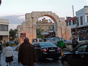
The monumental Roman arch (or Gate of Sun), approximately 700 meters west of Bab Sharqi, was excavated in 1947 and reconstructed at the present street level, on the exact spot where the Decumanus (now Via Recta) and the Cardo (north-south road) met. On both sides of the Via Recta, remains of the dug-out Roman columns have been put back in place – a very revealing sight! The city gate has kept its Roman features with a wide central arch for cart traffic and two smaller arches on each side for pedestrians. The ancient city walls are generally well preserved, but it is hard to figure out which parts are still Roman and which have been added later. They are a complete mixture of stones, bricks, blocked entrance doors, and opened windows from the houses built against the wall afterward.

This summarizes the Greek and Roman remains of the city. More ruins must be hidden five meters underground, as the excavated city gate and columns along the Via Recta have proven, but if or when future digs will be considered and carried out is a totally different story. Today Damascus has 1.7 million inhabitants, and the very core of the city (within the ancient walls) is very densely populated. I can’t see by what magic archaeologists will ever be able to map out the remains of so many superposed layers of occupation spreading over hundreds of centuries. Not anytime soon, anyway.

Tuesday, April 16, 2013

Apamea, heritage of Alexander

If we believe ancient Egyptian, Ugarian, and Hittite texts, Apamea goes back to 2000-1000 BC. Under Persian rule, it was called Pharnake. Still, the city entered my field of interest with Alexander the Great, who left a garrison behind and renamed it Pella after his hometown. The name Apamea appeared in 300/299 BC when Seleucos, a successor of Alexander, created one of the grandest cities in the east.


We have to go back to the mass wedding in Susa in 324 BC when Alexander arranged a mixed wedding party for about one hundred of his close friends and generals to bring Greece and Persia together. Seleucos' bride was to be Apame, the daughter of Spitamenes of Bactria. This union must have been happy, for it is the only one to survive Alexander's untimely death in 323 BC. Apame accompanied her husband during all of his expeditions and campaigns, which could not have been very comfortable traveling. In any case, after conquering the east, Seleucos decided to move the capital of his empire from Babylon to Antioch-on-the-Orontes, today's Antakya, Turkey. The region pleased him so much that he decided to dedicate another beautiful city over Pella, which was founded initially for Alexander's veterans. He renamed it Apamea after his wife. Apamea became his most important city, together with Antakya mentioned above. Laudetia, as Antakya was known by Seleucos, was named after his mother. Seleucia-on-the-Tigris was named after himself – yes, his empire reached all the way from the Mediterranean to the Indus! Seleucos truly moved in Alexander's footsteps!

The location of Apamea is worthy of Alexander, high above the fertile valley of the Orontes River, right on the junction of the busy road that connected the east with Antioch. Approaching today's town of Afamia, the visitor will see antique Apamea atop a trapezoidal hill just behind the new settlement – shining like a crown jewel. Vast parts of the 16 km-long city walls from the 2nd century BC and more than one hundred watch towers can still be seen, sometimes reaching as high as 10 meters. Apamea, I'm told, is four times the size of the more familiar Palmyra.

Pompey showed little consideration for Apamea when in 64 BC, the city became part of the Roman Empire. Yet it rose again and peaked at the beginning of the 1st century AD when the total population ran close to half a million (of which 380,000 were slaves), counting 40,000 horses and 500 fighting elephants. Unfortunately, Apamea was entirely destroyed during the cataclysmic earthquake on 13 December 115 AD (an estimated 7.5 on the scale of Richter).

This was the time to reform Apamea from a typical Hellenistic city into a Roman one. We may owe it to Emperor Trajan, who resided in nearby Antioch-on-the-Orontes at the time of the earthquake and nearly lost his life in the disaster, to rebuild Apamea. He kept the original Hippodamian plan which fitted the known Roman pattern anyway with a Cardo and a Decumanus. Apamea was enhanced with bath houses and public fountains, and near the original Hellenistic Agora, a new temple was dedicated to Belos or Baal. Near the city walls, a vast theater was built on the prior Hellenistic foundations, and it equaled the theater of Ephesus with a seating of over 20,000 persons! Roman/Byzantine Apamea lasted until it was conquered by the invading Muslims in 636 AD.

I have great expectations when I finally visit Apamea. For years, I have been in awe of the magnificent columns and mosaics that are the showpieces at the Archaeological Museum in Brussels. There, I saw the spiral columns for the first time, and when I met them later on in Sardes and Ephesus, I mentally kept calling them "Apamea columns." It is worth mentioning that the area was first excavated by Belgian archaeologists in the 1930s, and the restorations started in the 1970s – hence the museum pieces.

I enter Apamea from the north, next to the Antioch Gate. I immediately stop in my tracks since what I see is a Hellenistic city gate, two round towers just like the better-preserved ones that guard the entrance to Perge, Turkey – definitely a piece of the heritage left by Alexander through Seleucos, of course.

Turning to the south, I face the most impressive Cardo Maximus, once a busy commercial through road and as Roman as you can find. And amazing it is: nearly two kilometers long and 38 meters wide, lined initially with 1200 columns, of which 400 are still standing, each approximately 9 meters high and generally crowned with Corinthian capitals. The spiral columns, I expect, show up further down the road next to the Agora; till then, they are just plain.

On my left, behind the colonnade and paved sidewalk, stand well-preserved facades of shops, up to the first floor with decorated window and door frames – ready for use, it seems. The pavement of the Cardo is pretty much intact and clearly shows the traces left by the many carts that delivered the goods up and down the street.

The Cardo, which almost resembles a boulevard, is crossed by two Decumani. The first crossing is marked by a 14-meter-high votive column resting on a triangular base, smack in the middle of the straight road – something I haven't seen anywhere before. Walking over this centuries-old pavement flanked by these giant guards looking down on you is quite something! The gray clouds blend with the gray weathered columns and contribute to the melancholic atmosphere.

Further, down the Cardo, I find the Roman Baths built by Emperor Trajan (116-117). They are positioned so the water can flow down with gravity from the city walls. They were rebuilt and renewed time and again until the 7th century and were still functioning during the rule of the Ayubbids and Mameluks. Excavation works are underway, and earthen water and sewage pipes have recently been exposed. A little further on, I recognize the inevitable Nymphaeum, and behind it, I discover the public latrines fit to receive 80-90 people – a cozy place. Closer to the city center stands a column decorated with a relief of Bacchus carrying the thyrsus staff and framed with vine motives. This was once the basis of an arch signaling the entrance to a side street.

Finally, I reach the immense Agora (300 x 45 meters), where the typical spiral columns along the Cardo replace the otherwise unfluted ones. For me, this is how Apamea should be! After closer scrutiny, I noticed that the spirals twist alternatively to the right and to the left, which from a distance make a V-pattern creating a zigzag effect. Apparently, they date back to 166 AD. Three of these columns have a console holding a statue of Antoninus Pius, Lucius Verus, and Marcus Aurelius Antoninus. Another one carried a statue in honor of Lucius Julius Agrippa, a leading citizen of Apamea, set up by Quintus Munatis Marinus, who had the title of Beneficiarius as he helped to rebuild the city after the devastating earthquake of 115 AD. Further West are the remains of the famous Temple of Zeus Belos, known for its oracles and heavily visited by the believers, which included Emperor Septimius Severus. This temple was used without interruption till Christianity took over in 384-385 AD.

This is where I have to end my visit. The day is hiding behind the lead-colored clouds, and I deeply regret that I cannot take a picture of the golden sunrays illuminating these majestic colonnades. It is too late to walk down to the famous and grand theater at the end of the next Decumanus.

Apamea is a top location to visit as the remains from Hellenistic and Roman times are so vividly present. As I mentioned above, the city suffered heavily from the Muslim invasion, leading to its wealth decline. During the 7th century, however, Apamea knows a short revival with the coming of the Crusaders. In 1106 Prince Tancredi from Normandy arrived at the head of the First Crusade – later to be promoted to Prince of Galilea and Regent of the Princedom of Antioch. In 1157 and again in 1170, northern Syria was hit by a series of severe earthquakes, destroying Apamea and cities like Hama, Emesa (Homs), and Antioch-on-the-Orontes (Antakya).

It is certain that even in antiquity, Apamea appealed to everyone's imagination and received many important guests. Cleopatra VII stopped here on her way back from the Euphrates when she accompanied Marc Anthony on his campaign against the Armenians. Septimius Severus arrived in 179 as Legatus of the Fourth Scythian Legion, and later, in 215, Emperor Caracalla paid a visit on his way home after staying in Egypt. And now it is my turn!

At the foot of this marvelous city lies a caravanserai built around 1524 by the Ottomans, where merchants and pilgrims could rest and spend a night on their way to the Orontes Valley. The building has recently been restored and serves as a museum for the finds from Apamea, mainly grave steles and mosaics from private houses, among which the exceptional mosaic of Socrates and the Wise Men. However, the largest and probably the best-preserved mosaic is to be found in the Archaeological Museum in Brussels.

[Click here to view all the pictures of Apamea]

Saturday, April 13, 2013

Deir Ezzor on the Euphrates in Syria

Deir Ezzor is one of those cities whose foundations go back to the third millennium BC, the days of King Sargon I, till it fell in the hands of King Hammurabi (reigned 1728-1686 BC), followed by the Assyrians, the Chaldeans, and the Persians. It is located some 450 km northeast of Damascus on the banks of the Euphrates River. 

When Alexander the Great marched through Syria, Deir Ezzor became part of his empire. After his death in 323 BC, the country was ruled by Seleucos, one of his former generals. In Roman times this green oasis was a crossroad on the trade route that connected the Mediterranean Sea with India. We may not forget to mention Queen Zenobia who in the third century fervently opposed the Roman presence and occupied the city. 

By the fourth century, Deir Ezzor fell under the rule of Aleppo and afterward became part of the Ayubbid and the Mamluk empires. Tamerlane (read more under the Label Central Asia) and his Mongols totally destroyed Deir Ezzor in 1401, after which the city sank into the desert and disappeared.  

It is only in recent years, when oil was discovered in the region that Deir Ezzor was revived, and this is what we are seeing today.
The confrontation with the Euphrates River is always an exciting experience. The river was used as a frontier line for eons and still is – in fact, the other side (east) is where Mesopotamia starts. The French, who arrived here end of the 19th century built a narrow suspension bridge, a mini San Francisco Bay bridge, executed by nobody less than engineer Eifel! Recently, a wider modern bridge has been built for motorized traffic. It is an unforgettable adventure to cross this old bridge on foot as it is now reserved for pedestrians and to feel the soft swinging movement caused by our steps. The strong current of the Euphrates is clearly visible from up here and setting foot on Mesopotamian soil for just a short moment is definitely worth the detour. 
 
This is the story in a nutshell. Unfortunately, no traces have been found of Alexander’s presence here – not yet at least.

[Click here for more pictures of the cities along the Euphrates]

Wednesday, April 10, 2013

Valley of the Thracian Kings, Bulgaria

In my opinion, there are other and more urgent priorities in Bulgaria than to stimulate tourism and archaeological projects, but the Deputy Prime Minister and Finance Minister apparently think otherwise. They have decided to spend 3,5 million Leva (approx. 12,25 million Euros) on the entire project. 

A share of 3,5 million Leva (approx. 1,75 million Euros) is allotted to boost tourism in the Valley of the Thracian Kings in the Kazanlak area and study a Thracian tomb near the village of Buzovgrad. One million Leva will go towards archaeological studies, two millions towards infrastructure, and 500,000 Leva to improving water supply and sanitation. Bulgarian authorities hope that the Valley of the Thracian Kings will be added to UNESCO’s list of protected cultural heritage since they plan to link ten Thracian tombs together.

These Thracian tombs deserve much more attention than they are getting presently, for they are so unique! Several years ago, I had the opportunity to visit the Kazanlak Tomb, and I was very disappointed to learn on the spot that I only would see a replica. The original tomb was sealed off to protect it from outside influences; the inside air was kept at a steady temperature to guarantee the highest possible conservation level. A very understandable measure, of course, but utterly disappointing when you come all the way to see a mere copy. I hope this new project will enable the curious visitor to see part of the magnificent original wall paintings. 

This was several years ago after visiting an exhibition about the history of Bulgaria. It was an overwhelming experience, and I remember how I stared at the map of Bulgaria in an unsuccessful attempt to recognize any of the cities. All I could match with my memory was the capital Sofia and the town of Plovdiv because this was ancient Philippopolis founded by Philip II of Macedonia. The country was bordered in the north by Romania and in the south by Greece. Its eastern frontier touched the Black Sea, that much I knew, but that was about all. The exhibited artifacts were stunning, reaching back as far as 8,000 BC. This date was so abstract that I thought I was walking in circles when I arrived at the showcases with pieces from 800 BC! The artifacts showed such a high level of craftsmanship, an eye for details, and delicate and intricate work of precious metals, wood, bone, etc., that I was utterly baffled. I had no idea. 

This led me to visit Bulgaria to know more of its history, and one of the highlights for me obviously was Kazanlak, a city founded in the 7th century BC by the Thracians with a unique tomb that was discovered by chance in 1944 while digging around the Roman Baths built on top of it. The word “kazan” literally means “still,” very much like the stills used till recently in the rose industry.

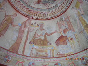
The Kazanlak Tomb, built during the 4th/3rd century BC, was smaller than I expected and counted three separate rooms: the entrance where the guests gathered for the funeral; a corridor with a pointed arched ceiling that reminded me of Agamemnon’s tomb although this one was painted; and finally the inner chamber where the walls and the circular ceiling were covered with frescos as well. The quality of these paintings clearly showed Greek influence yet executed conforming to Thracian traditions, how amazing! A novelty in those days was the perspective achieved by creating the light and shade effect. 

The Thracians could take up to six wives, and their favorite, generally the youngest one, was “allowed” to accompany her husband to the hereafter – a definite honor. Depends upon your opinion, of course. They considered that dying was a happy event because babies cried when they came into this world, meaning that the place they just left must simply be a better one. This is why the deceased is represented accompanied by his favorite wife and several highly prized horses. 

Evidently, there are many more tombs to visit, like the one of Buzovgrad mentioned above but also, I suppose, many others. The ones coming to my mind are the Ostrusha Tumulus near Shipka that counted six rooms. Also, the still sealed As mentioned before, a few remarkable tombs definitely deserve close attention. However, the Kazanlak Tomb is understandably closed to the public, who can visit a substitute replica next door.  from the 5th century BC. It contained a stunning massive gold vial in the shape of a gold mask like those discovered in Mycenae and Macedonia. However, this one was made from a much thicker sheet of gold. Finally, the Kosmatka Tumulus contained a splendid temple with an impressive façade where King Seuthes III, the founder of Seuthopolis, was buried in the early 3rd century BC. His magnificent head made of bronze shows a good-looking man, inspiring intelligence and nobility, indeed not the traits of a barbarian as one might think. 

In fact, I can’t wait till these unique tombs and tumuli are entirely made accessible to the public, another priority to put on my list!

Saturday, April 6, 2013

Roxane’s tomb linked to the Lion of Amphipolis?

Much sooner than I expected, there is a sequel to my short article “Has the tomb of Roxane and young Alexander been located?” In spite of financial shortcuts, it seems archaeological work on this site has not been halted.

We all known that it was Cassander who, as king of Macedonia, sent  Queen Roxane and her son by Alexander the Great to Amphipolis, to murder them both shortly afterwards. Under these circumstances it sounds very strange to hear that this tomb was erected by Dinocrates, builder of Alexandria in Egypt and favorite architect of Alexander the Great. Alexander had a soft spot for Amphipolis from where his fleet sailed east with him in 334 BC and the city he intended to honor with a magnificent temple – a plan that never materialized due to the king’s untimely death. 


Since my story appeared in October 2012, about three quarters of the total perimeter of the so-called Kasta Tumulus  has been exposed, making this tomb almost as large the one in Vergina. The wall of the monument is built of limestone blocks covered with marble slabs from Thassos. It is clear that part of the stones have disappeared or have been removed for use elsewhere over time. It is surprising however that archaeologists have been able to establish that the blocks of marble used in the reconstruction of the nearby Lion of Amphipolis are actually pertaining to this very tomb. It is obvious to whoever visited this lion monument, that a great number of lose blocks and columns are lying around. One of the architects working on the present excavations, M Lefantzis, went so far as to assume that the tomb itself once was covered with soil and topped with a lion, the one that has been reassembled further uphill and known as the Lion of Amphipolis.

During the second century AD, the tomb was deliberately and thoroughly destroyed by the Romans, dragging most of the blocks, including the lion into the Strymon River. Why this happened and why in such a violent way, I don’t know. At the times of the Balkan wars (1912-1913), Greek soldiers dug out a great deal of blocks from the Strymon riverbed, which led to reassembling the lion monument at the spot where we see it today. A great many pieces could not find a reasonable place in the reassembling works and they were left behind at the foot of the monument.

Today’s archaeologists are once again collecting and categorizing the numerous marble blocks from the river bed as well as from around the Lion of Amphipolis and because they have not found a penis, have come to the conclusion that we are looking at a lioness instead. While a lion-statue may be used to honor a male hero or king, a lioness traditionally crowns a female tomb. Because of the large size of the Roxane tumulus, it is automatically linked with a female of royal blood, and who else would be important enough here in Amphipolis at the end of the fourth century BC but Roxane?

The inside of the tumulus still remains a secret and it is quite an exciting thought that it might be the burial site of two persons so dear to Alexander, even if he has never seen his son and heir by Roxane.